
Watershed Management and Soil Conservation
Enroll to start learning
You’ve not yet enrolled in this course. Please enroll for free to listen to audio lessons, classroom podcasts and take practice test.
Interactive Audio Lesson
Listen to a student-teacher conversation explaining the topic in a relatable way.
Watershed Delineation and Characterization
🔒 Unlock Audio Lesson
Sign up and enroll to listen to this audio lesson

Today we're going to discuss watershed delineation and characterization. Who can tell me what a watershed is?

Isn't it an area of land that drains all the water to a common outlet?
Exactly! Now, we can delineate this watershed using tools like Digital Elevation Models, or DEMs. They help us define sub-basins. Can anyone explain why this is important?

It’s important for understanding how water flows and where potential flooding might happen.
Well done! Understanding the flow is essential for effective water management. Remember, the acronym *DRAIN* can help - "Delineate, Research, Analyze, Implement, and Navigate" your watersheds.

So DRAIN is all about the steps to manage watersheds?
Precisely! And there are morphometric analyses like bifurcation ratio that give insights into the watershed’s shape. Does anyone recall what that might indicate?

It could indicate the drainage patterns and potential runoff!
Great point! Remember, these characteristics help us prepare and manage water resources better.
Runoff and Sediment Control Measures
🔒 Unlock Audio Lesson
Sign up and enroll to listen to this audio lesson

Now let’s discuss some runoff and sediment control measures. What do you think is a common method we can use?
I’ve heard of terracing!
Correct! Terracing is one effective method for reducing soil erosion. Another technique is contour bunding. Can anyone explain how it works?
It's when you create a bund around the contour lines of a slope, right? It helps retain water and prevents runoff.
Exactly! Retaining water is the key to these strategies. As we talk about these methods, remember the mnemonic *BUND!* - which stands for Biodiversity, Utilizing, Nature, and Design!
That’s a creative way to remember it!
Additionally, models like WEPP and SWAT are significant. They help in predicting erosion rates and understanding the efficiency of our measures. Who can share the purpose of these models?
They assess soil and water processes to inform better management strategies.
Absolutely, well said! Utilizing these modern tools improves our watershed management practices.
Watershed Modeling
🔒 Unlock Audio Lesson
Sign up and enroll to listen to this audio lesson
Let's move on to watershed modeling. Why do you think modeling is crucial in this context?
It helps simulate different scenarios for better planning?
Exactly! Simulation is vital for managing water balance components. Can anyone name those components?
Evapotranspiration, infiltration, and baseflow?
Well done! These factors play a critical role in watershed health. We've learned about GIS-based models. How might GIS aid in watershed management?
GIS can visualize geology, hydrology, and human impacts on the watershed.
Precisely! Visualization aids decision-making in water resource management. To remember GIS’s role, consider the mnemonic *VISUAL* - it stands for ‘Visualize, Interpret, Study Using Analysis for Land’.
That’s a good way to remember the function of GIS.
And there you have it! Effective modeling leads to informed planning and practice in watershed management.
Introduction & Overview
Read summaries of the section's main ideas at different levels of detail.
Quick Overview
Standard
This section explores the importance of watershed delineation, characterization, and modeling along with various runoff and sediment control measures essential for effective soil conservation. It emphasizes practical applications of hydrological models to manage and protect water resources sustainably.
Detailed
Watershed Management and Soil Conservation
In this section, we delve deep into Watershed Management and Soil Conservation, which is crucial in maintaining ecological balance and ensuring sustainable land and water use. The first key aspect discussed is Watershed Delineation and Characterization, where tools such as Digital Elevation Models (DEM) help define sub-basin boundaries, while morphometric analyses facilitate better understanding of watershed characteristics.
The next focus is on Runoff and Sediment Control Measures that include techniques such as contour bunding, gully plugging, and terracing. These measures are vital for reducing soil erosion and maximizing water retention. Utilizing models like the Water Erosion Prediction Project (WEPP) and the Soil and Water Assessment Tool (SWAT) to predict soil erosion and assess the effectiveness of these measures is also emphasized.
Lastly, Watershed Modeling is introduced to simulate water balance components like evapotranspiration, infiltration, and baseflow. The use of GIS-based hydrological modeling is highlighted for effective planning and policy-making in water resource management. This integration of various methods illustrates how watershed management plays a vital role in sustainable engineering practices.
Youtube Videos

Audio Book
Dive deep into the subject with an immersive audiobook experience.
Watershed Delineation and Characterization
Chapter 1 of 3
🔒 Unlock Audio Chapter
Sign up and enroll to access the full audio experience
Chapter Content
• Use of DEM (Digital Elevation Models) for sub-basin delineation.
• Morphometric analysis: bifurcation ratio, form factor, etc.
Detailed Explanation
Watershed delineation refers to the process of defining the boundaries of a watershed or drainage basin. This can be done using Digital Elevation Models (DEMs), which are 3D representations of the Earth's surface. DEMs help identify the high and low points in the terrain to determine where water will flow. Morphometric analysis involves measuring the shape and features of the watershed, such as bifurcation ratio (which indicates how many tributaries flow into a river) and form factor (which helps estimate the watershed's response to rainfall).
Examples & Analogies
Imagine a bowl filled with water. The shape of the bowl determines how quickly the water will drain. Similarly, by understanding the shape of a watershed using DEMs, engineers can predict how water will flow through an area when it rains.
Runoff and Sediment Control Measures
Chapter 2 of 3
🔒 Unlock Audio Chapter
Sign up and enroll to access the full audio experience
Chapter Content
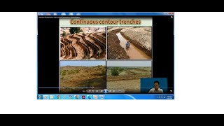
• Contour bunding, gully plugging, and terracing.
• Use of WEPP (Water Erosion Prediction Project) and SWAT (Soil and Water Assessment Tool) models.
Detailed Explanation
Runoff and sediment control measures are important practices used to prevent soil erosion and manage water flow in a watershed. Contour bunding involves creating barriers along the contour lines of a slope to slow down water runoff. Gully plugging means filling in gulleys to stop water from eroding the soil further. Terracing involves creating flat steps on steep land to catch water and reduce erosion. Models like WEPP and SWAT simulate how these methods can help reduce water and soil loss.
Examples & Analogies
Think of a gentle hillside after it rains. Without any barriers, the water flows quickly down the slope, washing away soil. By using methods like contour bunding, it’s like placing small walls along the hillside to slow the water down, allowing it to soak into the ground instead of running off.
Watershed Modeling
Chapter 3 of 3
🔒 Unlock Audio Chapter
Sign up and enroll to access the full audio experience
Chapter Content
• Simulation of water balance components: evapotranspiration, infiltration, baseflow.
• GIS-based hydrological modeling for planning and policy-making.
Detailed Explanation
Watershed modeling involves using simulations to understand various components of the water cycle within a watershed. This includes evapotranspiration (water evaporating from land and transpiring from plants), infiltration (water soaking into the ground), and baseflow (the portion of river flow that comes from groundwater). Geographic Information Systems (GIS) help visualize and analyze this data effectively, aiding in better planning and decision-making regarding water resources.
Examples & Analogies
Consider a sponge in a sink. When you pour water on it, some water soaks in (infiltration), some evaporates off the surface (evapotranspiration), and some gets pushed out as you squeeze it (baseflow). Models help us understand how all the water in a watershed behaves, just like watching how the sponge reacts to different amounts of water.
Key Concepts
-
Watershed Management: The process of guiding land and water resources in a watershed to ensure sustainable use.
-
Soil Conservation: Techniques aimed at preventing soil erosion and maintaining soil health.
-
Watershed Modeling: Simulating hydrological processes within a watershed to support planning and management.
-
Runoff Control: Measures to manage excess water flow to prevent soil degradation.
Examples & Applications
Using DEMs to delineate a watershed for a city’s water supply management.
Implementing contour bunding on steep agricultural lands to prevent soil erosion.
Memory Aids
Interactive tools to help you remember key concepts
Rhymes
When the rains come down with might, a watershed keeps waters tight.
Stories
Imagine a farmer on a hill using terraces to catch rain, keeping his crops and soil intact, saving water from runoff.
Memory Tools
Remember SURF for soil conservation methods - Structure, Utilize, Reduce, Filter.
Acronyms
Use *SWAM* - for understanding water management
Simulation
Water balance
Assessment
Management.
Flash Cards
Glossary
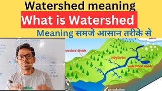
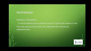
- Watershed
An area of land that drains all the water to a common outlet.
- Digital Elevation Models (DEM)
A 3D computer graphics representation of terrain elevation data.
- Morphometric Analysis
The quantitative analysis of the configuration of the Earth's surface.
- Contour Bunding
A method to form ditches or embankments along the contour lines of a slope.
- Terracing
Creating flat areas on the slope to retain water and reduce soil erosion.
- WEPP
Water Erosion Prediction Project, a model to predict erosion.
- SWAT
Soil and Water Assessment Tool, a model used to evaluate land and water management.
- Baseflow
The portion of streamflow that comes from groundwater.
Reference links
Supplementary resources to enhance your learning experience.