
EXERCISE
Enroll to start learning
You’ve not yet enrolled in this course. Please enroll for free to listen to audio lessons, classroom podcasts and take practice test.
Interactive Audio Lesson
Listen to a student-teacher conversation explaining the topic in a relatable way.
Introduction to India's Physiographic Divisions
🔒 Unlock Audio Lesson
Sign up and enroll to listen to this audio lesson

Today, we'll learn about the major physiographic divisions of India. Let's start by mentioning how India includes diverse landforms, such as mountains, plains, and deserts. Can anyone tell me what the major divisions are?

Is it the Himalayas, Northern Plains, and Peninsular Plateau?
Exactly! The Himalayas are the tallest mountains in India. Remember the acronym 'HINPIID' to recall: Himalayas, Indian Desert, Northern Plains, Peninsular Plateau, Islands, and Coastal Plains.

What makes the Himalayas so significant?
Great question! They impact climate, provide water resources, and are home to rich biodiversity.

Are the Himalayas the youngest mountains in India?
Yes, they are! The whole system is geologically young and continues to influence India's physical geography.

What’s the height of Mt. Everest?
It stands at 8,848 meters, the highest point on Earth!
To summarize this session: India has diverse landforms including the Himalayas, Northern Plains, and Peninsular Plateau, with the Himalayas being the youngest mountains.
Exploring the Northern Plains
🔒 Unlock Audio Lesson
Sign up and enroll to listen to this audio lesson

Now, let’s examine the Northern Plains. Who can explain how they were formed?
They were formed by alluvial deposits from rivers.
Correct! The Ganga, Indus, and Brahmaputra contribute to these plains. Remember, 'Flatlands Fertile' to recall its features.
What does 'Doab' mean?
It means 'land between rivers', specifically two rivers. This region is highly productive for agriculture.
What region is known for its wetlands?
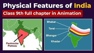
That would be the 'Terai' region, south of the Bhabar belt, which is crucial for biodiversity.
In summary, the Northern Plains are fertile and vital for agriculture, formed by river deposits and characterized by regions such as Doab and Terai.
The Unique Features of the Peninsular Plateau
🔒 Unlock Audio Lesson
Sign up and enroll to listen to this audio lesson
Let's shift our focus to the Peninsular Plateau, known for its unique geological features. Can anyone describe its main divisions?
It has the Central Highlands and the Deccan Plateau.
That's right! This plateau is ancient, consisting mainly of igneous and metamorphic rocks. Remember: 'Tall and Wide' for Central Highlands and Deccan.
What about the black soil region?
The black soil, which is essential for cotton cultivation, is primarily found in the Deccan region.
What are the major rivers here?
The major rivers, like the Godavari and Krishna, flow eastwards, feeding into the Bay of Bengal. It’s essential to know this flow direction!
Summarizing, the Peninsular Plateau is divided into the Central Highlands and Deccan Plateau, known for its minerals and black soil.
Introduction & Overview
Read summaries of the section's main ideas at different levels of detail.
Quick Overview
Standard
The section provides an overview of India's varied terrain, detailing major physical features such as the Himalayas, Northern Plains, Peninsular Plateau, Indian Desert, Coastal Plains, and Islands. It emphasizes geological aspects, altitudinal variations, and the significant role these features play in India's geography.
Detailed
Detailed Summary of Section 5: EXERCISE
India is known for its vast geographical diversity, encapsulated within several major physiographic divisions, including mountains, plains, deserts, plateaus, and islands. Each of these divisions displays unique characteristics and geological formations. The Himalayas, for instance, are the most prominent mountain range, geologically young and consisting of three main parallel ranges. In contrast, the Northern Plains, formed by alluvial deposits from major rivers, contrast starkly with the rugged, ancient Peninsular Plateau, constituted of igneous and metamorphic rocks.
Major Physiographic Divisions:
- The Himalayan Mountains: Stretching from west to east, these mountains form a formidable barrier with high peaks such as Mt. Everest and Kanchenjunga. They also include sub-ranges like Himachal and Shiwaliks, with diverse altitudinal variations and valleys.
- The Northern Plains: Formed primarily by the Ganga, Indus, and Brahmaputra river systems, these plains are fertile and densely populated, consisting of alluvial soil and featuring regions like Doab and Terai.
- The Peninsular Plateau: An ancient landmass characterized by its tablelands and rounded hills, divided into Central Highlands and Deccan Plateau, famous for its mineral resources.
- The Indian Desert: Located in the west, this region is arid with sand dunes, minimal rainfall, and sparse vegetation.
- The Coastal Plains: Narrow strips along the western and eastern coasts that include notable features like the Konkan and Malabar coasts.
- The Islands: Two main groups, Lakshadweep and Andaman & Nicobar Islands, known for their biodiversity and strategic importance.
These geographical features collectively enrich India's natural resources and potential for development.
Youtube Videos


Audio Book
Dive deep into the subject with an immersive audiobook experience.
Understanding India's Physical Features
Chapter 1 of 4
🔒 Unlock Audio Chapter
Sign up and enroll to access the full audio experience
Chapter Content
You have already learnt earlier that India is a vast country with varied land forms. What kind of terrain do you live in? If you live in the plains, you are familiar with the vast stretches of plain land. In contrast, if you live in hilly region, the rugged terrain with mountains and valleys are common features. In fact, our country has practically all major physical features of the earth, i.e., mountains, plains, deserts, plateaus and islands.
Detailed Explanation
This chunk introduces the diversity of India's geographical landscapes. India consists of various terrains including mountains, plains, deserts, plateaus, and islands. The type of terrain one lives in influences their experience and activities, defining their immediate environment. For instance, those in plains encounter wide-open spaces ideal for agriculture, while those in hilly areas deal with steep landscapes that can be beautiful but challenging for farming.
Examples & Analogies
Think of India like a buffet with different types of food. If you like spicy dishes, you might enjoy the terrain in the hilly areas (like trying spicy curries), while if you prefer milder flavors, living in the plains (like enjoying bread and rice) might be more appealing.
Major Physiographic Divisions
Chapter 2 of 4
🔒 Unlock Audio Chapter
Sign up and enroll to access the full audio experience
Chapter Content
The physical features of India can be grouped under the following physiographic divisions: (1) The Himalayan Mountains (2) The Northern Plains (3) The Peninsular Plateau (4) The Indian Desert (5) The Coastal Plains (6) The Islands.
Detailed Explanation
This portion outlines the six major physiographic divisions of India. Each division has distinct characteristics: the Himalayan Mountains are known for their height and ruggedness; the Northern Plains are known for their flat, fertile lands; the Peninsular Plateau consists of ancient rock formations; the Indian Desert features dry and sandy terrains; the Coastal Plains are bordered by water, providing unique ecological conditions; and the Islands offer a different biodiversity compared to the mainland.
Examples & Analogies
Imagine India's landscape as a big jigsaw puzzle where each piece represents a different geographic feature. Just like how every piece is unique but fits together to complete the picture, each physiographic division contributes to India’s overall environment and biodiversity.
Identifying Key Physical Features
Chapter 3 of 4
🔒 Unlock Audio Chapter
Sign up and enroll to access the full audio experience
Chapter Content
Choose the right answer from the four alternatives given below. (i) A landmass bounded by sea on three sides is referred to as (a) Coast (c) Peninsula (b) Island (d) None of the above.
Detailed Explanation
This part focuses on understanding specific geographical terms. For example, a peninsula is a land area that is surrounded by water on three sides but is connected to the mainland, while an island is fully surrounded by water. Learning these terms helps students identify and describe physical features effectively.
Examples & Analogies
You can think of a peninsula like a person's arm (the land) reaching out into a pool (the sea), while an island is like their hand that is completely submerged in the water. Both are related to water but have different relationships with the land.
Exploring India's Physiography
Chapter 4 of 4
🔒 Unlock Audio Chapter
Sign up and enroll to access the full audio experience
Chapter Content
A detailed account of the different physiographic units highlights the unique features of each region. It would, however, be clear that each region complements the other and makes the country richer in its natural resources.
Detailed Explanation
This chunk emphasizes the interconnectivity of India’s physiographic regions, suggesting that each provides unique resources that enhance the country’s overall wealth. For example, mountains provide water, the plains are fertile for crops, and plateaus yield minerals. Together, they support diverse ecosystems and economic activities.
Examples & Analogies
Consider a team working on a project where each member has different skills. One might be good at research (mountains), another at writing (plains), while someone else excels in design (plateaus). Together, they create a successful project, much like how different geographical features contribute to the richness of India.
Key Concepts
-
Himalayan Mountains: The youngest and most prominent mountain range in India, crucial for climate and water resources.
-
Northern Plains: Fertile agricultural plains formed by alluvial deposits from rivers.
-
Peninsular Plateau: An ancient landform with diverse geology, rich in minerals.
Examples & Applications
The Himalayas contain peaks like Mount Everest and Kanchenjunga.
The Northern Plains support major crops due to their fertile alluvial soil.
The Deccan Plateau is known for black soil, ideal for cotton farming.
Memory Aids
Interactive tools to help you remember key concepts
Rhymes
Himalayas rise, touching the sky, Northern plains with crops nearby.
Stories
Once, in a land called India, the great Himalayas watched over fertile plains, ensuring bountiful harvests due to the rivers flowing from their heights.
Memory Tools
Remember 'HINPIID' for the major divisions: Himalayas, Indian Desert, Northern Plains, Peninsular Plateau, Islands, Coastal Plains.
Acronyms
PINE
Plateau
Islands
Northern Plains
Eastern Ghats.
Flash Cards
Glossary
- Physiographic Divisions
The classification of a country's terrain based on physical geography.
- Alluvial Soil
Soil that is made up of materials deposited by rivers, highly fertile and good for agriculture.
- Bhabar
A region of coarse alluvial deposits at the foothills of the Himalayas.
- Terai
Low-lying marshy areas south of the Bhabar region, rich in biodiversity.
Reference links
Supplementary resources to enhance your learning experience.