
MAP SKILLS
Enroll to start learning
You’ve not yet enrolled in this course. Please enroll for free to listen to audio lessons, classroom podcasts and take practice test.
Interactive Audio Lesson
Listen to a student-teacher conversation explaining the topic in a relatable way.
Introduction to India's Physio-geographic Diversity
🔒 Unlock Audio Lesson
Sign up and enroll to listen to this audio lesson

Today, we will explore the diverse physical geography of India. Can anyone tell me what they know about the major landforms in India?

I know there are mountains like the Himalayas and plains like the Indo-Gangetic region.
Exactly! India has mountains, plains, plateaus, deserts, coastal areas, and islands. This diversity is crucial for our ecosystem. Let’s start with the mountains. Can you name some major peaks?

Mount Everest and Kanchenjunga?
Right! The Himalayas boast the highest peaks including Mount Everest. We can remember them with the acronym 'HIM'—Himalayas, India, Mountains. Now, who can describe the Northern Plains?
The Himalayan Mountains
🔒 Unlock Audio Lesson
Sign up and enroll to listen to this audio lesson

The Himalayas are not only the highest but also a vital source of rivers. The northern-most range is called the Great Himalayas, or Himadri. What do you think is distinctive about this range?

It has the loftiest peaks, doesn't it?
Correct! With an average height of 6,000 meters, it contains significant peaks like Kanchenjunga and Nanga Parbat. Can anyone think of how these ranges influence local climates?

They probably block cold winds and bring rain.
Exactly, mountains influence weather patterns greatly. Let's summarize: the acronym 'HIGHT' could help us remember—Himalayas, Influences, Geography, Heights, topography.
The Northern Plains
🔒 Unlock Audio Lesson
Sign up and enroll to listen to this audio lesson
The Northern Plains are formed by the alluvial deposits of major rivers. Why do you think this region is so fertile?
Because of the river silt deposited over centuries?
Exactly! The alluvial soil makes it one of the most agriculturally productive areas. Can anyone name two key rivers associated with these plains?
The Ganga and the Brahmaputra!
Excellent! Remember, we can use the mnemonic 'PGB'—Punjab, Ganga, Brahmaputra to recall key regions. What are some of the challenges faced in these plains?
The Peninsular Plateau
🔒 Unlock Audio Lesson
Sign up and enroll to listen to this audio lesson
Moving on to the Peninsular Plateau, can anyone describe its composition and its significance?
It's made of old crystalline rocks and is rich in minerals!
Absolutely! It’s formed from the ancient Gondwana fragments. Let’s create a rhyme to remember its features, 'Old rocks and minerals, in plateau’s embrace, making India’s wealth, in every place.' What are some major divisions within this plateau?
The Central Highlands and the Deccan Plateau!
Great job! That covers some critical aspects of the Peninsular Plateau. Always remember, ‘PAM’ for Plateau, Ancient, Minerals.
Coastal Plains and Islands
🔒 Unlock Audio Lesson
Sign up and enroll to listen to this audio lesson
Finally, let’s discuss the Coastal Plains and Islands. Who can tell me about the significance of these areas?
They are important for fishing and trade!
Correct! The western coast is narrow and flanked by the Western Ghats. We can remember the western coast with 'Konkan for Mumbai, Malabar for Kerala'. Now, what unique features do the Lakshadweep and Andaman Islands have?
Lakshadweep has coral reefs and Andaman is known for its diverse fauna?
Yes, well done! Remember, ‘Coral Lakshadweep, Wild Andaman.’
Introduction & Overview
Read summaries of the section's main ideas at different levels of detail.
Quick Overview
Standard
This section provides an overview of India's varied geographic terrain, including mountains, plains, plateaus, deserts, coastal areas, and islands. Each feature is discussed in terms of geological formation, significance, and unique characteristics, helping to understand the nation's rich physical landscape.
Detailed
Detailed Summary
This section elaborates on the diverse physical features of India, emphasizing its varied terrain, which reflects major physiographic divisions. India is characterized by:
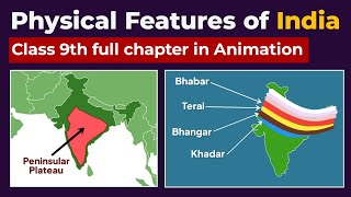
- The Himalayan Mountains: These are geologically young and represent the loftiest mountain barrier in the world, running about 2,400 km from the Indus to the Brahmaputra. They consist of the Great Himalayas, Lesser Himalayas, and Shiwaliks, each possessing unique features such as high peaks, valleys, and glaciers.
- The Northern Plains: Formed by the river systems of the Indus, Ganga, and Brahmaputra, these plains are composed of fertile alluvial soil. They are critical for agriculture and are densely populated.
- The Peninsular Plateau: Comprised of old crystalline, igneous, and metamorphic rocks, this plateau includes significant features such as the Central Highlands and the Deccan Plateau, which are rich in minerals and biodiversity.
- The Indian Desert: An arid climate with low vegetation, this region is primarily located on the western side of the Aravalis, receiving minimal rainfall.
- The Coastal Plains and Islands: Stretching along the Arabian Sea and the Bay of Bengal, these plains are significant for fishing and trade and include coral islands like Lakshadweep and Andaman & Nicobar Islands.
Overall, the unique geographical features contribute to India's rich cultural and natural resources, illustrating a complex interaction between various physical landscapes.
Youtube Videos


Audio Book
Dive deep into the subject with an immersive audiobook experience.
Mountain and Hill Ranges
Chapter 1 of 5
🔒 Unlock Audio Chapter
Sign up and enroll to access the full audio experience
Chapter Content
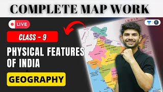
On an outline map of India show the following.
(i) Mountain and hill ranges – the Karakoram, the Zaskar, the Patkai Bum, the Jaintia, the Vindhya range, the Aravali, and the Cardamom hills.
Detailed Explanation
This chunk discusses different mountain and hill ranges in India that should be marked on a map. Key mountain ranges include the Karakoram, known for K2, the Zaskar, which is famous for its scenic beauty, the Patkai Bum and Jaintia which are important for biodiversity, and the Vindhya and Aravali ranges, which are historically significant and rich in minerals. The Cardamom hills, located in Kerala, are known for their spice plantations and unique ecosystems.
Examples & Analogies
Imagine you have a giant jigsaw puzzle that represents the physical geography of India. Each mountain and hill range is like a piece of that puzzle. Just as each piece fits together to show a bigger picture, each mountain range contributes to the overall landscape and environment of India, impacting climate, biodiversity, and human activities.
Peaks to Show on the Map
Chapter 2 of 5
🔒 Unlock Audio Chapter
Sign up and enroll to access the full audio experience
Chapter Content
(ii) Peaks – K2, Kanchenjunga, Nanga Parbat and the Anai Mudi.
Detailed Explanation
This chunk lists some of the most significant peaks in India and nearby regions. K2, located in the Karakoram range, is the second-highest mountain in the world, while Kanchenjunga is the highest peak in India. Nanga Parbat, belonging to the Himalayas, is known for its challenging climbing routes. Anai Mudi is the highest peak in the Western Ghats. Understanding the location of these peaks helps aficionados of geography and mountaineering appreciate the grandeur of these natural formations.
Examples & Analogies
Think of these peaks like the trophies in a sports competition. Just as each trophy represents a significant achievement in sports, each of these peaks signifies a remarkable achievement in nature's grandeur. Climbing these peaks is akin to reaching the pinnacle of success in mountaineering, where climbers push their limits to stand on these 'trophies' of nature.
Plateaus to Highlight
Chapter 3 of 5
🔒 Unlock Audio Chapter
Sign up and enroll to access the full audio experience
Chapter Content
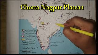
(iii) Plateaus, Chotanagpur and Malwa.
Detailed Explanation
This segment points out two prominent plateaus in India – Chotanagpur and Malwa. The Chotanagpur Plateau, located in eastern India, is rich in minerals and a vital area for coal and iron ore mining. Similarly, the Malwa Plateau, situated in Madhya Pradesh, is known for its agricultural lands and historical significance. Recognizing these plateaus is crucial for understanding India's resource distribution and economic activities.
Examples & Analogies
You can think of plateaus as large flat tables spread across the landscape. Just like a table can hold various objects, plateaus hold key resources and support diverse ecosystems. When people settle on these plateaus, they utilize the flat, stable land for farming and building homes, just as we often gather around a table for meals and activities.
The Indian Desert
Chapter 4 of 5
🔒 Unlock Audio Chapter
Sign up and enroll to access the full audio experience
Chapter Content
(iv) The Indian Desert.
Detailed Explanation
This section emphasizes the location of the Indian Desert, predominantly found in Rajasthan. Characterized by dry terrain, sand dunes, and sparse vegetation, the desert plays a significant role in India's biodiversity and tourism. The climate is harsh, receiving very little rainfall, which influences the lifestyle of the people and the types of flora and fauna that can survive there.
Examples & Analogies
Imagine living on a seemingly endless sandy beach where it rarely rains. Just like this beach has its own unique plants and animals adapted to sandy and dry conditions, the Indian desert has its own special ecosystem. Residents and wildlife adapt to the challenges presented by the heat and lack of water, much like an artist learns to work with limited materials to create beautiful art.
Lakshadweep Islands
Chapter 5 of 5
🔒 Unlock Audio Chapter
Sign up and enroll to access the full audio experience
Chapter Content
The Lakshadweep Islands.
Detailed Explanation
In this portion, attention is drawn to the Lakshadweep Islands, an archipelago off the southwestern coast of India. Known for their stunning coral reefs and rich biodiversity, these islands offer unique landscapes and marine environments. Marking them on a map helps in understanding their geographical significance and the natural beauty they contribute to India.
Examples & Analogies
Think of the Lakshadweep Islands as jewels scattered in the ocean. Each island, like a unique gem, possesses its own distinct beauty and characteristics. Just as jewels can enhance a jewelry piece, these islands enrich India’s cultural and natural tapestry, attracting tourists and providing a habitat for diverse marine life.
Key Concepts
-
Major Physiographic Divisions: Key physical features of India, including mountains, plains, deserts, and islands.
-
Himalayan Mountains: Significant mountain range affecting weather and water sources.
-
Northern Plains: Fertile region crucial for agriculture.
-
Peninsular Plateau: Oldest landmass rich in minerals.
-
Indian Desert: Arid region characterized by sand dunes and low vegetation.
-
Coastal Regions and Islands: Important for trade, biodiversity, and unique ecosystems.
Examples & Applications
The Himalayas serve not only as a geographical barrier but play a significant role in water resources for major river systems like the Ganga.
The fertile Northern Plains account for a large portion of India's total agricultural output.
Memory Aids
Interactive tools to help you remember key concepts
Rhymes
Mountains tall, plains so wide, deserts dry, and oceans tide.
Stories
Once upon a time, the Himalayas stood tall and proud, providing water to a village below, while the plains bloomed with crops to feed everyone. But in the desert, the sand had its own story to tell.
Memory Tools
P-H-I-C-P-I: Plains, Himalayas, Islands, Coastal, Plateau, Indian Desert.
Acronyms
MAPS
Mountains
Alluvial
Plateau
Sea.
Flash Cards
Glossary
- Physiographic Divisions
The various geographical features dividing a region into distinct areas based on physical characteristics.
- Alluvial Soil
Fertile soil made up of silt and clay deposited by rivers.
- Plateau
An area of high ground that is flat or gently sloping.
- Coral Islands
Islands formed from coral deposits, usually found in tropical oceans.
Reference links
Supplementary resources to enhance your learning experience.