
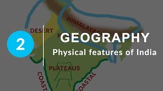
MAJOR PHYSIOGRAPHIC DIVISIONS
Enroll to start learning
You’ve not yet enrolled in this course. Please enroll for free to listen to audio lessons, classroom podcasts and take practice test.
Interactive Audio Lesson
Listen to a student-teacher conversation explaining the topic in a relatable way.
Introduction to Physiographic Divisions
🔒 Unlock Audio Lesson
Sign up and enroll to listen to this audio lesson

Today, we will explore the major physiographic divisions of India. Can anyone tell me what they think a physiographic division is?

I think it refers to different types of landforms in a geographical area.
That's correct! These divisions include features like mountains, plains, and plateaus, and they shape our environment. Now, can anyone name a major division in India?

The Himalayas!
Exactly! The Himalayas are a significant feature, stretching across the north of India. Remember, we can use the acronym 'HIPPIC' for the main divisions: Himalayas, Indian Plains, Peninsular Plateau, Indian Desert, Coastal Plains, and Islands. Let's dig deeper into each of these.
Himalayan Mountains
🔒 Unlock Audio Lesson
Sign up and enroll to listen to this audio lesson

The Himalayas are geologically young mountains stretching from the Indus to the Brahmaputra rivers. What distinguishes them from other mountains?

They're really high and have a rugged terrain!
Correct! They are indeed the loftiest mountain range in the world. Their tallest peak is Mt. Everest. Can anyone tell me what types of rocks are found there?

Granite rocks, I think?
Yes! The Great Himalayas mainly consist of granite. As we look at the Himalayan ranges, remember the acronym GLAM, which stands for Great Himalayas, Lesser Himalayas, and Shiwaliks.
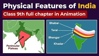
Northern Plains
🔒 Unlock Audio Lesson
Sign up and enroll to listen to this audio lesson
Now, let's move to the Northern Plains, which cover around 7 lakh square kilometers. What do you think contributes to the fertility of this region?
The rivers that flow through it must bring nutrient-rich soil!
That's right! Specifically, alluvial deposits from rivers like the Ganga and Brahmaputra enrich the soil. Who can explain the terms 'bhangar' and 'khadar'?
Bhangar is older alluvium, while khadar is the new, fertile alluvium.
Excellent explanation! Understanding these terms helps us grasp agricultural practices in this region.
Peninsular Plateau
🔒 Unlock Audio Lesson
Sign up and enroll to listen to this audio lesson
Next, we have the Peninsular Plateau, an ancient landmass formed from igneous and metamorphic rocks. What are its main divisions?
The Central Highlands and the Deccan Plateau!
That's correct! The plateau shows a variety of relief features. Can anyone describe how this area formed?
It was formed due to the breaking and drifting of Gondwana land?
Exactly! This knowledge helps us appreciate the geological history of our country.
Introduction & Overview
Read summaries of the section's main ideas at different levels of detail.
Quick Overview
Standard
The section outlines India's major physiographic divisions, including the Himalayan Mountains, Northern Plains, Peninsular Plateau, Indian Desert, Coastal Plains, and Islands, highlighting their geographical characteristics and significance. Each division is distinct in terms of geological formation and ecological importance, shaping the cultural and economic aspects of the nation.
Detailed
Major Physiographic Divisions
India's geography is characterized by significant diversity, representing various physiographic divisions including:
- The Himalayan Mountains: These fold mountains are geologically young and stretch across northern India, offering a rugged terrain with lofty peaks and deep valleys.
- The Northern Plains: Formed by alluvial deposits from major river systems, this fertile region is crucial for agriculture and has a rich soil cover.
- The Peninsular Plateau: Comprising ancient igneous and metamorphic rocks, this plateau is known for its highland regions and is divided into the Central Highlands and the Deccan Plateau.
- The Indian Desert: Located in western India, this region features undulating sand dunes with minimal vegetation and a dry climate.
- The Coastal Plains: Narrow strips along India's coastlines, these areas vary between the Arabian Sea and Bay of Bengal with rich biodiversity and are important for fishing and port activities.
- The Islands: The Lakshadweep and Andaman and Nicobar Islands contribute to India's biodiversity and strategic significance.
Understanding these divisions is essential for grasping India's complex topography and the interactions between its physical features and human activity.
Youtube Videos


Audio Book
Dive deep into the subject with an immersive audiobook experience.
Overview of India's Physiographic Divisions
Chapter 1 of 6
🔒 Unlock Audio Chapter
Sign up and enroll to access the full audio experience
Chapter Content
The physical features of India can be grouped under the following physiographic divisions:
(1) The Himalayan Mountains
(2) The Northern Plains
(3) The Peninsular Plateau
(4) The Indian Desert
(5) The Coastal Plains
(6) The Islands
Detailed Explanation
India's geography is diverse and can be categorized into six major physiographic divisions. These divisions include various landforms like mountains, plains, deserts, plateaus, coastal areas, and islands. Let's briefly outline each one:
1. The Himalayan Mountains - These are towering mountains located in the northern part of India.
2. The Northern Plains - A large expanse of flat land made fertile by river systems.
3. The Peninsular Plateau - A table-like structure consisting of ancient rocks.
4. The Indian Desert - A dry, sandy region with very low rainfall.
5. The Coastal Plains - Narrow stretches of land by the sea, on both the western and eastern sides of India.
6. The Islands - Groups of islands in both the Arabian Sea and the Bay of Bengal.
Examples & Analogies
Think of India as a large cake with multiple layers. Each layer represents a different geographical feature, much like how each layer of a cake has its own flavor and texture. From the ‘fluffy’ mountains of the Himalayas at the top, the ‘moist’ plains in the middle, to the ‘dry’ desert layer at the bottom, each region contributes to the overall structure and flavor of the country.
The Himalayan Mountains
Chapter 2 of 6
🔒 Unlock Audio Chapter
Sign up and enroll to access the full audio experience
Chapter Content
The Himalayas, geologically young and structurally fold mountains, stretch over the northern borders of India. These mountain ranges run in a west-east direction from the Indus to the Brahmaputra. They form an arc, which covers a distance of about 2,400 Km. The Himalayas consist of three parallel ranges in its longitudinal extent.
Detailed Explanation
The Himalayan Mountains are among the youngest mountains in the world and are characterized as fold mountains. This means they were formed by the collision of tectonic plates, causing the earth's crust to fold and rise, creating peaks. They stretch roughly 2,400 kilometers and include three main ranges:
1. The Great Himalayas (Himadri) - The highest range that contains the tallest peaks, including Mount Everest.
2. The Lesser Himalayas (Himachal) - Known for its rugged mountains and valleys.
3. The Outer Himalayas (Shiwaliks) - The foothills that are the narrowest but rich in sediment.
Examples & Analogies
Imagine the Himalayas as a massive, intricately folded blanket. As you pull at the blanket (the tectonic plates), folds and peaks form where the material is pushed up, creating the stunning landscape we see today. Just like a blanket can have different textures and patterns, the Himalayas consist of various ranges, each with unique features.
The Northern Plains
Chapter 3 of 6
🔒 Unlock Audio Chapter
Sign up and enroll to access the full audio experience
Chapter Content
The northern plain has been formed by the interplay of the three major river systems, namely—the Indus, the Ganga, and the Brahmaputra along with their tributaries. This plain is formed of alluvial soil, spreading over an area of 7 lakh sq. km.
Detailed Explanation
The Northern Plains are formed primarily from the alluvial deposits left by these three river systems. This alluvial soil is very fertile, making the region suitable for agriculture. The plains are also intricately woven with numerous rivers and streams, ensuring ample water supply, which adds to its agricultural productivity. Different regions within the plains are marked by their respective rivers, with areas like Punjab and Haryana benefiting greatly from this fertile plain.
Examples & Analogies
Think of the Northern Plains as a giant sponge soaking up water. Just as a sponge retains water and remains moist, the Northern Plains retain fertility from river sediments that nourish crops. The rivers act like the ‘pipelines’ that carry essential nutrients, assuring that the land remains productive and lush for farming.
The Peninsular Plateau
Chapter 4 of 6
🔒 Unlock Audio Chapter
Sign up and enroll to access the full audio experience
Chapter Content
The Peninsular Plateau is a tableland composed of the old crystalline, igneous, and metamorphic rocks. It was formed due to the breaking and drifting of the Gondwana land and thus, making it a part of the oldest landmass.
Detailed Explanation
The Peninsular Plateau consists of ancient rocks that have formed a flat surface ideal for various types of vegetation. This plateau is divided into two main parts: the Central Highlands, located in the north, and the Deccan Plateau in the south. These areas have rich mineral resources and diverse ecosystems. The rugged terrain includes hills and valleys, exhibiting a unique beauty compared to the plains.
Examples & Analogies
Imagine a giant, weathered stone table sitting in a park. Over the years, rain and wind have smoothed the surface while different landscaping elements grow around it. Similarly, the Peninsular Plateau is an ancient rocky formation that has been shaped by natural elements, providing ground for various plants and minerals.
The Indian Desert
Chapter 5 of 6
🔒 Unlock Audio Chapter
Sign up and enroll to access the full audio experience
Chapter Content
The Indian desert lies towards the western margins of the Aravali Hills. It is an undulating sandy plain covered with sand dunes, receiving very low rainfall below 150 mm per year.
Detailed Explanation
The Indian Desert, primarily the Thar Desert, is characterized by its dry, sandy landscape and sparse vegetation. It experiences extremely low rainfall, resulting in a harsh climate. The desert features dunes formed by wind action, giving it a unique beauty. Despite its arid conditions, it supports a variety of flora and fauna that have adapted to survival in such an environment.
Examples & Analogies
Think of the Thar Desert like a vast ocean of sand, with waves shaped by wind instead of water. Just as the ocean has unique marine life adapted to its environment, the desert has plants and animals that thrive in extreme dryness, showcasing nature’s resilience and adaptability.
The Coastal Plains and Islands
Chapter 6 of 6
🔒 Unlock Audio Chapter
Sign up and enroll to access the full audio experience
Chapter Content
The Peninsular plateau is flanked by stretches of narrow coastal strips, running along the Arabian Sea on the west and the Bay of Bengal on the east. These coastal areas are rich in biodiversity and provide significant economic resources.
Detailed Explanation
The coastal plains are important geographical features that run along India's shorelines. They support numerous economic activities like fishing, trade, and tourism. The coastal environment also hosts a rich variety of plants and animals, including specialized species found in marine and estuarine ecosystems. Additionally, islands such as the Lakshadweep and Andaman and Nicobar are crucial for biodiversity and strategic reasons.
Examples & Analogies
Picture the coast as a vibrant marketplace filled with merchants selling fresh produce. Just like a marketplace is bustling with life, the coastal plains of India are alive with diverse ecosystems and human activities, offering a wealth of resources and opportunities for economic development.
Key Concepts
-
Himalayan Mountains: The youngest fold mountains that stretch across northern India, known for their height and ruggedness.
-
Northern Plains: Fertile alluvial plains formed by major river systems, crucial for agriculture.
-
Peninsular Plateau: An ancient tableland consisting of igneous and metamorphic rocks, divided into Central Highlands and Deccan Plateau.
-
Indian Desert: Arid plains in the western region, characterized by sand dunes and sparse vegetation.
-
Coastal Plains: Narrow strips of land along the coastlines of India that are ecologically diverse.
Examples & Applications
The Himalayas in India host peaks such as Mt. Everest and Kanchenjunga, representing high mountainous terrain.
The Northern Plains are rich agricultural areas due to alluvial deposits, essential for crops such as rice and wheat.
The Peninsular Plateau's Deccan region contains minerals that support industries, highlighting its economic importance.
Memory Aids
Interactive tools to help you remember key concepts
Rhymes
Himalayas lofty, Northern Plains flow, Peninsular Plateaus in a rich tableau.
Stories
In ancient times, mighty rivers carved the fertile Northern Plains, while the Himalayas stood as eternal guards against the skies.
Memory Tools
HIPPIC - Himalayas, Indian Plains, Peninsular Plateau, Indian Desert, Coastal Plains, Islands.
Acronyms
G-P-S - Geography of Plains, Subcontinents, and variations.
Flash Cards
Glossary
- Physiographic Division
A distinct landform or terrain that has different characteristics from other regions.
- Alluvial Deposit
Soil and sediment deposited by rivers, typically rich in nutrients.
- Granite
A strong, hard igneous rock often found in mountain ranges.
- Bhangar
Older alluvium found in the Northern Plains.
- Khadar
Younger alluvium deposited in the floodplains, known for fertility.
Reference links
Supplementary resources to enhance your learning experience.