
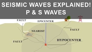
Instrumentation and Monitoring of Fault Activity
Enroll to start learning
You’ve not yet enrolled in this course. Please enroll for free to listen to audio lessons, classroom podcasts and take practice test.
Interactive Audio Lesson
Listen to a student-teacher conversation explaining the topic in a relatable way.
Importance of Monitoring Faults
🔒 Unlock Audio Lesson
Sign up and enroll to listen to this audio lesson

Today, we will explore why monitoring active faults is crucial. Can anyone tell me what a fault is?

A fault is a fracture in the Earth's crust where movement occurs.
Exactly! And because faults can trigger earthquakes, monitoring them helps us prepare and mitigate hazards. Why do you think it's important to measure fault activity?

To predict earthquakes and minimize damage!
Right! Monitoring helps us identify patterns of activity. Let's discuss the instruments used for this purpose.
Instruments Used in Monitoring
🔒 Unlock Audio Lesson
Sign up and enroll to listen to this audio lesson

First, we have GPS stations that detect crustal deformations. Why do we use GPS for this?

Because GPS can detect movements very accurately, right?
Exactly! It can measure movement down to millimeters. Now, what about seismographs? What role do they play?

They record ground motions, which helps us understand seismic events better.
Precisely! Seismographs are critical for tracking earthquake activity. Who can tell me about strainmeters?
Advanced Monitoring Techniques
🔒 Unlock Audio Lesson
Sign up and enroll to listen to this audio lesson
Another exciting technology is InSAR, which uses satellite imagery. Has anyone heard of it?
It's used to detect surface movements from space, isn't it?
Yes! It allows us to monitor large areas continuously and detect subtle shifts. Now, can anyone summarize why these monitoring techniques matter?
They help us predict earthquakes, assess risks, and develop early warning systems!
That's a great summary! Remember, effective monitoring is key to reducing disaster impacts.
Introduction & Overview
Read summaries of the section's main ideas at different levels of detail.
Quick Overview
Standard
This section emphasizes the significance of monitoring active faults to enhance early warning systems and effective hazard mitigation. It highlights various instruments, including GPS, seismographs, and InSAR, which aid in detecting and recording fault activity.
Detailed
Instrumentation and Monitoring of Fault Activity
Monitoring active faults is essential for early warning systems and hazard mitigation, given that faults are zones of weakness that can lead to earthquakes. Implementing advanced instrumentation plays a crucial role in tracking motion and deformation across these fault lines. The tools and techniques detailed in this section include:
- GPS Stations: These devices can detect minute crustal deformations with millimeter precision, helping to identify potential fault movements.
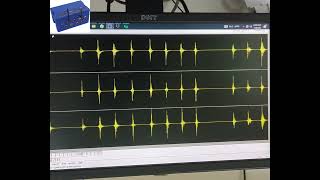
- Seismographs: Used extensively to record ground motion, these instruments provide critical data about seismic activity related to faults.
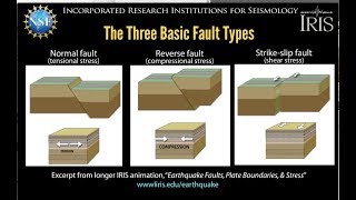
- Strainmeters and Tiltmeters: These devices measure stress and tilt across fault planes, essential for understanding the mechanics of fault movement.
- InSAR (Interferometric Synthetic Aperture Radar): This satellite-based imaging technique detects surface movement over large areas, facilitating the monitoring of fault activity remotely.
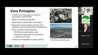
The integration of these technologies is vital for institutions, such as the National Centre for Seismology (NCS) in India, which actively monitoring significant fault lines in regions like the Himalayas and Kachchh. Effective fault monitoring aids in predicting seismic events and advancing our understanding of geological processes.
Youtube Videos


Audio Book
Dive deep into the subject with an immersive audiobook experience.
Instruments Used for Monitoring
Chapter 1 of 2
🔒 Unlock Audio Chapter
Sign up and enroll to access the full audio experience
Chapter Content
Monitoring active faults is essential for early warning systems and hazard mitigation.
Instruments Used:
- GPS Stations: Detect crustal deformation with millimeter precision.
- Seismographs: Record ground motion.
- Strainmeters and Tiltmeters: Measure stress and tilt across fault planes.
- InSAR (Interferometric Synthetic Aperture Radar): Satellite-based imaging for detecting surface movement.
Detailed Explanation
This chunk focuses on the instruments utilized to monitor fault activity. Each instrument has a unique function: GPS stations measure even minute changes in the Earth's surface, helping researchers understand how faults move over time. Seismographs are devices that capture seismic waves from the ground, providing data on earthquakes. Strainmeters and tiltmeters are specialized instruments that measure the stress and tilting of the ground along fault lines, indicating the potential for future movement. Lastly, InSAR is a modern technique using satellite technology to observe surface deformation, allowing scientists to visualize how faults are shifting over large areas.
Examples & Analogies
Imagine monitoring a balloon being inflated. GPS stations are like the measuring tape, tracking how much the balloon expands, while seismographs are similar to the sound recording device, capturing the sounds of the balloon's surface cracking under pressure. Strainmeters and tiltmeters act like gauges, providing insights into how tense the balloon material is, while InSAR uses satellite technology, much like a drone, to take a wide-angle view of the balloon's shape as it inflates.
Real-Time Fault Monitoring
Chapter 2 of 2
🔒 Unlock Audio Chapter
Sign up and enroll to access the full audio experience
Chapter Content
Real-Time Fault Monitoring
Active faults in India (e.g., Himalayas, Kachchh) are now monitored by institutions like the National Centre for Seismology (NCS).
Detailed Explanation
This chunk highlights the implementation of real-time monitoring systems for active faults, particularly in significant regions of India. Institutions like the National Centre for Seismology are dedicated to tracking seismic activity in places prone to earthquakes. By continuously observing these faults, scientists can gather real-time data that helps predict potential seismic events, allowing for timely warnings and readiness for areas at risk of earthquakes.
Examples & Analogies
Think of real-time fault monitoring like a weather station that provides updates about approaching storms. Just as weather stations track changes in atmospheric pressure and temperature to warn us about potential thunderstorms, the National Centre for Seismology uses advanced technology to monitor fault lines and give communities advance notice of potential earthquakes, helping them prepare and mitigate damage.
Key Concepts
-
Monitoring Active Faults: Essential for early warning systems and hazard mitigation.
-
Instrumentation: Various tools like GPS, seismographs, and InSAR are used to monitor fault activity.
-
Real-Time Data: Continuous monitoring provides up-to-date information on fault movements.
Examples & Applications
GPS technology is utilized to detect shifts in the crust where fault lines are active.
Seismographs collect data during earthquake events, providing insights into ground motion.
Memory Aids
Interactive tools to help you remember key concepts
Rhymes
To monitor faults and keep them in sight, GPS and seismographs help make it right.
Stories
Once upon a time, in a land of shifting plates, scientists used tools like GPS to keep track of their fates. Seismographs acted like ears, listening day and night for the tremors and shakes that would give them a fright.
Memory Tools
GSS for GPS, Seismographs, and Strainmeters used for faulting.
Acronyms
G- Graceful; P- Precision; S- Science
GPS used for precise monitoring of faults.
Flash Cards
Glossary
- GPS Stations
Devices that detect crustal deformation with millimeter precision.
- Seismographs
Instruments that record ground motion, crucial for understanding seismic activity.
- Strainmeters
Instruments used to measure the stress and tilt across fault planes.
- Tiltmeters
Devices that measure the angle or tilt of the ground, indicating fault movement.
- InSAR
Interferometric Synthetic Aperture Radar; a satellite-based technique for detecting surface movement.
Reference links
Supplementary resources to enhance your learning experience.