
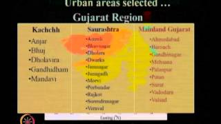
Mapping and Identification of Faults
Enroll to start learning
You’ve not yet enrolled in this course. Please enroll for free to listen to audio lessons, classroom podcasts and take practice test.
Interactive Audio Lesson
Listen to a student-teacher conversation explaining the topic in a relatable way.
Geological Mapping
🔒 Unlock Audio Lesson
Sign up and enroll to listen to this audio lesson

Let's start with geological mapping. This involves observing surface features to identify faults. Can anyone tell me what some visible signs of a fault might be?

Maybe cliffs or steep drops in the land?
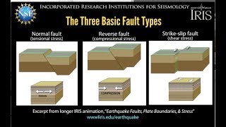
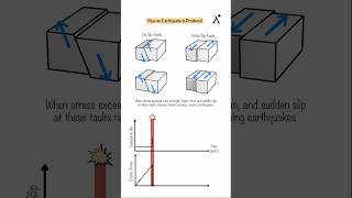
Exactly! We often see fault scarps, which are cliffs created by faulting. Who can recall how a fault scarp is formed?

It occurs when one block of rock moves up or down relative to another?
Yes! Great explanation. It's essential for understanding how faults can shape the landscape.
Remote Sensing and Aerial Photography
🔒 Unlock Audio Lesson
Sign up and enroll to listen to this audio lesson

Next, we have remote sensing and aerial photography. Why do you think these methods are useful for mapping faults?

Because they can show larger areas than what we can walk on?
Exactly! They help us visualize linear features and identify offsets in landscapes like rivers. This is crucial for spotting faults that aren't visible at ground level.

How do they identify faults in rivers specifically?
Good question! Observing a river that suddenly shifts direction can indicate a fault line beneath it.
Seismological Studies
🔒 Unlock Audio Lesson
Sign up and enroll to listen to this audio lesson
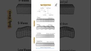
Now, let’s talk about seismological studies. How can studying seismic waves help us map faults?
They can show us where earthquakes are happening, right?
Exactly! By looking at the distribution of earthquake epicenters, we can infer where active faults might be. Do we remember the importance of this information?
It helps in assessing seismic hazards for building design!
Correct! Knowing where the faults are can inform urban planning and construction.
Geophysical Surveys
🔒 Unlock Audio Lesson
Sign up and enroll to listen to this audio lesson
Let’s move on to geophysical surveys. Can anyone explain what types of measurements this includes?
Things like gravity and magnetic measurements?
Right! These surveys can help detect fault properties without direct observation. How does this non-invasive approach benefit geologists?
It allows them to assess areas that are hard to reach.
Exactly! It’s also less disruptive than digging trenches.
Trenching and Paleoseismology
🔒 Unlock Audio Lesson
Sign up and enroll to listen to this audio lesson
Finally, let's discuss trenching and paleoseismology. What is the significance of digging trenches to study faults?
It lets researchers see past events and how often earthquakes happen on that fault.
Yes, fantastic! Dating these past movements helps us predict future seismic activity. Why is this important?
It helps engineers design safer buildings and infrastructure.
Correct again! Understanding the history of fault movements is key to risk assessment.
Introduction & Overview
Read summaries of the section's main ideas at different levels of detail.
Quick Overview
Standard
The section outlines several methodologies for mapping and identifying faults, including geological mapping, remote sensing, and paleoseismology. These tools allow scientists and engineers to understand fault behavior, assess seismic risks, and inform infrastructure planning.
Detailed
Mapping and Identification of Faults
Mapping and identifying geological faults is essential in understanding the seismic hazards they pose. Various techniques are employed to accurately characterize and study faults. These techniques include:
- Geological Mapping: Involves studying surface features and rock displacements to identify fault locations.
- Remote Sensing and Aerial Photography: Utilizes satellite images and photographs to visualize fault lines, recognizing linear features and offset patterns like rivers and fault scarps.
- Seismological Studies: Analyzes seismic data to determine the alignment of earthquake epicenters and patterns of seismic reflection.
- Geophysical Surveys: Apply physical methods, such as gravity and magnetic surveys, to detect fault locations and properties indirectly.
- Trenching and Paleoseismology: Involves excavating sites to study sediment layers for evidence of past fault movements and earthquakes, helping to date these events and understand recurrence intervals.
Understanding these techniques is vital for civil engineers in designing earthquake-resistant infrastructure and assessing the safety of urban areas near tectonic activity. Proper mapping helps minimize risks associated with fault-generated seismic events.
Youtube Videos


Audio Book
Dive deep into the subject with an immersive audiobook experience.
Geological Mapping
Chapter 1 of 5
🔒 Unlock Audio Chapter
Sign up and enroll to access the full audio experience
Chapter Content
- Geological Mapping: Surface features and rock displacements.
Detailed Explanation
Geological mapping involves the study of the surface features of the Earth to identify the presence of faults. This includes examining how rocks are arranged and displaced. When geologists map an area, they look for signs of past movements, such as cliffs or ridges that indicate a fault line.
Examples & Analogies
Think of geological mapping like a detective solving a mystery. Just as a detective looks for clues like footprints or broken windows to identify what happened, geologists examine the landscape for rock formations and shifts to determine where faults may exist.
Remote Sensing and Aerial Photography
Chapter 2 of 5
🔒 Unlock Audio Chapter
Sign up and enroll to access the full audio experience
Chapter Content
- Remote Sensing and Aerial Photography: Linear features, offset rivers, fault scarps.
Detailed Explanation
Remote sensing and aerial photography allow scientists to observe and analyze large areas from above, providing a bird's-eye view of the Earth’s surface. This method helps in identifying linear features, such as straight lines that indicate the presence of fault scarps or rivers that have been offset due to fault movement. By analyzing these images, researchers can pinpoint where faults may be located without needing to physically survey the area.
Examples & Analogies
Imagine trying to find a straight road in a thick forest. Aerial photography is like using a drone to get a clear view of the entire area from above, making it easier to spot the road (or in this case, faults).
Seismological Studies
Chapter 3 of 5
🔒 Unlock Audio Chapter
Sign up and enroll to access the full audio experience
Chapter Content
- Seismological Studies: Epicenter alignment and seismic reflection.
Detailed Explanation
Seismological studies focus on understanding earthquakes and the behavior of faults during seismic events. Scientists monitor the epicenter of earthquakes – the point directly above where an earthquake originates – and look for patterns in seismic activity. Seismic reflection techniques involve sending waves into the ground and analyzing how they bounce back, which helps identify fault planes and their characteristics.
Examples & Analogies
Consider throwing a rock into a calm pond. The ripples that spread out resemble seismic waves. By observing the ripples and their changes, you can gather information about the rock’s impact, just as scientists use seismic studies to learn about faults and earthquakes.
Geophysical Surveys
Chapter 4 of 5
🔒 Unlock Audio Chapter
Sign up and enroll to access the full audio experience
Chapter Content
- Geophysical Surveys: Gravity, magnetic, and resistivity methods.
Detailed Explanation
Geophysical surveys utilize various techniques to measure the physical properties of the Earth’s crust. Methods like gravity surveys can detect changes in density that might indicate the presence of a fault. Magnetic surveys look for variations in the Earth's magnetic field caused by geological structures, while resistivity surveys measure how easily electrical currents pass through the ground, indicating different materials and structures beneath the surface.
Examples & Analogies
Think of geophysical surveys like using different tools to check the quality of a cake. Each tool gives you different information about whether the cake is baked correctly (like gravity measurements giving you clues about the Earth’s structure).
Trenching and Paleoseismology
Chapter 5 of 5
🔒 Unlock Audio Chapter
Sign up and enroll to access the full audio experience
Chapter Content
- Trenching and Paleoseismology: Dating past fault movements.
Detailed Explanation
Trenching involves digging across a fault line to study the layers of rock and sediment that have accumulated over time. By examining these layers, scientists can determine when past earthquakes occurred, how often they happen, and the history of fault movements. This study of past seismic activity is called paleoseismology, and it helps predict future fault behavior.
Examples & Analogies
Imagine sifting through a stack of old newspapers to find out what events happened in the past. By examining these layers, you can piece together a timeline of what has occurred, similar to how trenching helps scientists understand the history of fault movements.
Key Concepts
-
Geological Mapping: Identifying faults through surface features and rock displacement.
-
Remote Sensing: Using technology to visualize fault patterns and features.
-
Seismological Studies: Analyzing seismic data to locate faults.
-
Geophysical Surveys: Measuring physical earth properties to detect faults.
-
Paleoseismology: Studying geological evidence of earthquakes to understand fault history.
Examples & Applications
Observing visible offsets in rivers or cliffs can indicate the presence and activity of a fault.
Trenching can uncover sediment layers that show evidence of past earthquakes, revealing the fault's activity history.
Memory Aids
Interactive tools to help you remember key concepts
Rhymes
Faults can be hard to see, but with mapping, we set them free.
Stories
Imagine a geologist walking through a valley, noticing the way rivers twist and turn; these signs reveal the hidden faults beneath the surface.
Memory Tools
Remember 'G-R-S-G-P' for fault mapping: Geological mapping, Remote Sensing, Seismological studies, Geophysical surveys, Paleoseismology.
Acronyms
G-R-S-G-P helps recall the methods of fault identification!
Flash Cards
Glossary
- Geological Mapping
The process of observing surface features and rock displacements to identify and map faults.
- Remote Sensing
The use of satellite images or aerial photographs to identify features and patterns on the Earth's surface.
- Seismological Studies
The field of study focused on the observation and analysis of seismic waves and their effects, used to identify faults.
- Geophysical Surveys
Techniques that measure physical properties of the Earth, such as gravity and magnetism, for fault detection.
- Paleoseismology
The study of past earthquake activity on faults through geological evidence and excavation.
Reference links
Supplementary resources to enhance your learning experience.