
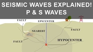
Fault Geometry and Terminology
Enroll to start learning
You’ve not yet enrolled in this course. Please enroll for free to listen to audio lessons, classroom podcasts and take practice test.
Interactive Audio Lesson
Listen to a student-teacher conversation explaining the topic in a relatable way.
Understanding Fault Strike
🔒 Unlock Audio Lesson
Sign up and enroll to listen to this audio lesson

Today we're going to explore the concept of 'strike' in fault geometry. Strike refers to the direction of the line formed by the intersection of a fault plane with a horizontal surface.

How do we determine the strike of a fault?
Great question! Let's say we're standing on a horizontal surface and looking at a fault. We can observe the line where the fault crosses the surface; that line's direction is the strike. Think of it as finding the 'heading' of the fault!

So, does it help us understand the fault’s potential behavior?
Exactly! Knowing the strike allows geologists to predict how stress might be distributed along the fault.

Can we visualize this in a 3D model?
Definitely! Various geological software can create 3D models of faults, illustrating strike visually.
In summary, strike is crucial for understanding the geometry of faults and predicting how they might behave during seismic events.
Exploring Fault Dip
🔒 Unlock Audio Lesson
Sign up and enroll to listen to this audio lesson

Let's move on to 'dip', which complements the concept of strike. Dip is the angle between the fault plane and a horizontal plane.

How does the dip angle affect fault behavior?
Great question! A steeper dip often means more significant vertical displacement during a seismic event, which can affect how buildings are constructed nearby.
Is there a way to measure dip accurately?
Yes! Geologists use clinometers or digital inclinometers to measure the dip angle directly in the field.
So understanding dip helps engineers design better structures?
Exactly! Knowing how steep a fault is allows engineers to plan for potential movements.
To summarize, dip is a vital aspect of fault geometry that influences how we assess seismic risks.
Understanding Slip and Fault Trace
🔒 Unlock Audio Lesson
Sign up and enroll to listen to this audio lesson
Next, we have 'slip', which is the relative displacement across the fault. This tells us how much one side of the fault moves concerning the other.
How do we measure slip in an earthquake?
Typically, we examine geological features that have been displaced; that change gives us the slip amount.
And what's 'fault trace'?
Good question! The fault trace is the visible line where the fault intersects the Earth's surface. This direct observation is important for mapping.
Can identifying the fault trace help in predicting earthquakes?
Definitely! Identifying fault traces aids in assessing areas at risk of seismic activity.
To conclude, slip and fault trace are integral in assessing the nature and impact of faults.
Fault Zones Explained
🔒 Unlock Audio Lesson
Sign up and enroll to listen to this audio lesson
Finally, let's discuss fault zones, which encompass regions with closely spaced faults.
How does recognizing a fault zone affect engineering projects?
Identifying a fault zone is crucial since these areas can significantly amplify seismic activity.
Are there different types of fault zones?
Yes! For instance, some zones are active, showing constant movement, while others may appear dormant but can reactivate under stress.
So engineers need to evaluate these zones carefully before building?
Correct! Proper assessment of fault zones helps minimize structural risk.
In summary, recognizing fault zones is essential for earthquake risk assessment and infrastructure development.
Introduction & Overview
Read summaries of the section's main ideas at different levels of detail.
Quick Overview
Standard
Fault geometry encompasses key terms and concepts that are vital for interpreting how faults behave and assessing their seismic risks. It includes definitions of fault strike, dip, slip, fault trace, and fault zone, providing a fundamental framework for understanding the nature and impact of geological faults.
Detailed
Fault Geometry and Terminology
Understanding fault geometry is essential in geology, particularly for interpreting fault behavior and seismic potential. This section delves into key terms such as:
- Strike: This refers to the direction of the line formed by the intersection of a fault plane with a horizontal surface. Understanding strike helps in visualizing how a fault is oriented in the landscape.
- Dip: The angle between the fault plane and a horizontal surface, measured perpendicular to the strike. Knowing the dip is significant for assessing the risks during seismic events.
- Slip: This is the relative displacement across a fault, indicating how much one block of rock has moved relative to another.
- Fault Trace: The line where a fault intersects the Earth's surface, which can be critical in determining where surface-based investigations might need to occur.
- Fault Zone: A region containing multiple closely spaced faults. Recognizing these zones helps assess seismic risks more accurately.
Grasping these terminologies and their implications is crucial for engineers and geologists as they assess risks and design infrastructure in seismically active areas.
Youtube Videos


Audio Book
Dive deep into the subject with an immersive audiobook experience.
Introduction to Fault Geometry
Chapter 1 of 6
🔒 Unlock Audio Chapter
Sign up and enroll to access the full audio experience
Chapter Content
Understanding fault geometry is crucial for interpreting fault behavior and seismic potential.
Detailed Explanation
This chunk introduces the importance of fault geometry in understanding how faults behave during seismic activity. Fault geometry refers to the spatial arrangement and orientation of faults in the Earth's crust. Proper understanding of these geometrical characteristics enables geologists and engineers to assess the seismic potential of a fault, which plays a significant role in earthquake prediction and risk mitigation.
Examples & Analogies
Think of a fault like a zipper on a jacket. How the zipper is aligned (its geometry) determines how well it functions. If it’s off-track, it may not close properly, leading to issues—just like a fault can lead to earthquakes if it’s not well understood.
Strike
Chapter 2 of 6
🔒 Unlock Audio Chapter
Sign up and enroll to access the full audio experience
Chapter Content
Strike: Direction of the line formed by the intersection of a fault plane with a horizontal surface.
Detailed Explanation
The 'strike' of a fault describes the compass direction of a horizontal line that is formed when a fault plane intersects the Earth's surface. Understanding the strike helps to visualize the orientation of the fault and is vital in geological mapping and assessing how the fault might move or rupture during seismic events.
Examples & Analogies
Imagine drawing a line on a piece of paper and then tilting the paper. The direction of the line you drew represents the strike, indicating how the fault would behave when the ground moves.
Dip
Chapter 3 of 6
🔒 Unlock Audio Chapter
Sign up and enroll to access the full audio experience
Chapter Content
Dip: Angle between the fault plane and a horizontal surface, measured perpendicular to the strike.
Detailed Explanation
The 'dip' refers to how steeply a fault is inclined relative to a horizontal plane. It is measured at a right angle to the strike. The dip angle provides important information about the potential movement of the fault and can influence how an earthquake propagates within the Earth's crust.
Examples & Analogies
Imagine a slide at a playground. The angle of the slide relative to the ground represents the dip. A steeper slide (high dip) will send you down faster, just as a steep fault may result in more violent earthquake movements.
Slip
Chapter 4 of 6
🔒 Unlock Audio Chapter
Sign up and enroll to access the full audio experience
Chapter Content
Slip: The relative displacement across a fault.
Detailed Explanation
Slip refers to the distance and direction that rock blocks have moved past one another along a fault. This movement can be critical in determining the magnitude of an earthquake. Understanding slip helps engineers design structures that can withstand potential displacements during seismic activity.
Examples & Analogies
Imagine two cars parked side by side in a parking lot. If one car rolls away, the distance it moves over the line that divides the two parking spaces represents the slip. In terms of faults, understanding how much the rocks move helps us predict the effects of earthquakes.
Fault Trace
Chapter 5 of 6
🔒 Unlock Audio Chapter
Sign up and enroll to access the full audio experience
Chapter Content
Fault Trace: The line where a fault intersects the Earth’s surface.
Detailed Explanation
The 'fault trace' is essentially the visible manifestation of a fault on the Earth's surface, where the fault line can be seen. This trace is important for mapping and studying the fault, helping scientists and engineers identify its location and understand its behavior.
Examples & Analogies
Think of a fault trace like the path left in the sand when a piece of furniture is dragged across it. The line marks where the furniture shifted, just as the fault trace marks where the fault has moved and can provide clues about its history.
Fault Zone
Chapter 6 of 6
🔒 Unlock Audio Chapter
Sign up and enroll to access the full audio experience
Chapter Content
Fault Zone: A region with multiple closely spaced faults.
Detailed Explanation
A fault zone is a larger area that encompasses multiple faults that are closely spaced together. These zones can be complex and involve various interactions between different faults, making them particularly important in assessing seismic risk and understanding earthquake dynamics.
Examples & Analogies
Imagine a cluster of trees that are all planted close together. Each tree represents a different fault, and the area where they all grow closely creates a forest—this is akin to a fault zone. Just as competition among trees can affect their growth, the interaction among faults can influence seismic behavior.
Key Concepts
-
Strike: Direction of the line formed by a fault in relation to horizontal surface.
-
Dip: The angle between the fault plane and a horizontal surface.
-
Slip: The relative movement of rock across a fault.
-
Fault Trace: The line where a fault intersects with the ground.
-
Fault Zone: An area characterized by multiple adjacent faults.
Examples & Applications
An example of a normal fault can be seen in the Basin and Range Province of the United States, where extensional forces are causing the land to stretch.
In a left-lateral strike-slip fault, if you stand on one side of the fault and see the opposite side move to the left, this demonstrates the concept effectively.
Memory Aids
Interactive tools to help you remember key concepts
Rhymes
When we think of dip, it's the angle, you see; steep means more shake, that's the geologist's plea!
Stories
Imagine two tectonic plates in a dance. They twist and turn, creating a line (fault trace). The angle they form (dip) decides who shakes most during their sway.
Memory Tools
To remember the components of fault geometry, use 'SDSFT': Strike, Dip, Slip, Fault Trace to keep them in mind!
Acronyms
Remember 'STOP'
Strike (direction)
(angle - dip)
(offset - slip)
(line - fault trace) to detail fault geometry!
Flash Cards
Glossary
- Strike
The direction of the line formed by the intersection of a fault plane with a horizontal surface.
- Dip
The angle between the fault plane and a horizontal surface, measured perpendicular to the strike.
- Slip
The relative displacement across a fault.
- Fault Trace
The line where a fault intersects the Earth’s surface.
- Fault Zone
A region that contains multiple closely spaced faults.
Reference links
Supplementary resources to enhance your learning experience.