
Recent Advances in Liquefaction Assessment
Enroll to start learning
You’ve not yet enrolled in this course. Please enroll for free to listen to audio lessons, classroom podcasts and take practice test.
Interactive Audio Lesson
Listen to a student-teacher conversation explaining the topic in a relatable way.
Advanced Site Characterization
🔒 Unlock Audio Lesson
Sign up and enroll to listen to this audio lesson

Today, we'll discuss how advanced site characterization enhances our ability to assess liquefaction. Can anyone tell me about recent tools we use for this?

I've heard of seismic Cone Penetration Tests. What do they do exactly?
Great question! Seismic CPT helps us measure soil properties and resistance directly. Additionally, techniques like LiDAR and InSAR allow us to observe surface deformations from space. This combination provides a clearer picture of the soil’s condition.

So these technologies can actually spot problems before they cause damage?
Exactly! By detecting anomalies early on, we can take preventive measures. Remember the acronym 'LIDS' — LiDAR, InSAR, Downhole seismic—these tools lead to better site assessment.

What’s the real benefit of using remote sensing?
Remote sensing gives us a broad view of our site without needing physical access. It enhances data collection speed and accuracy.

That sounds important for predicting earthquakes!
It is! In conclusion, advanced site characterization is a game-changer in predicting liquefaction potential. Let's summarize: we focused on seismic CPT, LiDAR, and InSAR.
Numerical Modeling Techniques
🔒 Unlock Audio Lesson
Sign up and enroll to listen to this audio lesson

Now, let’s delve into numerical modeling techniques. Who knows how these models differ from traditional methods?
I think they simulate soil behavior under seismic conditions, right?
Correct! They can replicate how soil behaves when subjected to shaking. Finite element and finite difference methods enable us to visualize this effectively.
What does a coupled flow-deformation model do?
Good question! It models the interaction between water flow and soil deformation during seismic events, giving us insight into excess pore pressure build-up.
So, we can predict when liquefaction might happen?
Precisely! Accurate predictions allow engineers to design safer structures. A way to remember this is by thinking of 'SAFE' — Simulating Affects of Forces and Environment.
How do these predictions help in real-life situations?
They guide us in making informed decisions, especially in designing foundations in earthquake-prone areas. Today, we learned about numerical modeling, its techniques, and benefits.
Machine Learning Applications
🔒 Unlock Audio Lesson
Sign up and enroll to listen to this audio lesson
Lastly, let’s talk about machine learning applications in liquefaction assessment. Does anyone know how AI helps in this field?
Isn't it about analyzing past data to predict future outcomes?
Exactly! By training models on historical liquefaction data, we can improve prediction accuracy dramatically.
What kind of data do these models use?
They typically use Standard Penetration Test data, Cone Penetration Test results, and specific earthquake parameters. This approach gives us a data-driven understanding of liquefaction risk.
Can machine learning help us design better structures?
Absolutely! Predictive modeling allows engineers to anticipate and mitigate risks effectively. Think of the acronym 'PREDICT' — Predictive Risk Evaluations and Design Insights for Construction Techniques.
So machine learning can really change the game in this field?
Yes! To sum up, machine learning enhances our liquefaction prediction capabilities, allowing us to make informed decisions in civil engineering.
Introduction & Overview
Read summaries of the section's main ideas at different levels of detail.
Quick Overview
Standard
Recent advancements in liquefaction assessment focus on improving prediction and mitigation strategies through advanced site characterization methods, such as seismic CPT and satellite technologies, enhanced numerical modeling techniques using finite element methods, and machine learning applications that leverage historical data for improved prediction accuracy.
Detailed
Recent Advances in Liquefaction Assessment
The field of liquefaction assessment is evolving rapidly, driven by technological advances and research innovations. Understanding and predicting liquefaction phenomena are crucial in engineering and construction, particularly in earthquake-prone areas. This section outlines three main advancements in liquefaction assessment:
1. Advanced Site Characterization
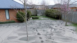
Recent techniques like seismic Cone Penetration Tests (CPT) and downhole seismic velocity profiling enhance the evaluation of soil properties at a site. Additionally, remote sensing technologies, including LiDAR and satellite-based InSAR (Interferometric Synthetic Aperture Radar), effectively detect surface deformations associated with liquefaction during seismic events. These tools provide detailed insight into soil conditions, which is essential for accurate liquefaction potential assessments.
2. Numerical Modelling
Numerical modeling methods, particularly finite element and finite difference approaches, are being developed to simulate soil behavior more realistically during earthquake loading. Coupled flow-deformation models allow for improved understanding of how pore water pressure interacts with soil deformation during seismic events, leading to better predictions of liquefaction behavior under various conditions.
3. Machine Learning Applications
Machine learning (AI/ML) techniques are becoming significant in the field of liquefaction assessment. By training models on historical liquefaction data, researchers can enhance prediction accuracy based on various inputs, such as Standard Penetration Test (SPT) and Cone Penetration Test (CPT) data, earthquake parameters, and soil characteristics. This data-driven approach could revolutionize how liquefaction risk is assessed, leading to more informed decision-making in seismic engineering.
Youtube Videos


Audio Book
Dive deep into the subject with an immersive audiobook experience.
Advanced Site Characterization
Chapter 1 of 3
🔒 Unlock Audio Chapter
Sign up and enroll to access the full audio experience
Chapter Content
Use of seismic CPT and downhole Vs profiling.
LiDAR and satellite-based InSAR to detect surface deformation.
Detailed Explanation
Advanced site characterization involves utilizing modern techniques to gather detailed information about the soils and their responses during seismic events. Seismic Cone Penetration Testing (CPT) and downhole shear wave velocity (Vs) profiling are methods used to assess soil properties and layering at various depths. Additionally, technologies like LiDAR (Light Detection and Ranging) and satellite-based InSAR (Interferometric Synthetic Aperture Radar) help in monitoring surface deformations caused by possible liquefaction, providing crucial data that can influence design and mitigation strategies.
Examples & Analogies
Think of advanced site characterization like using a detailed map before a long hike. Just as a good map helps you navigate terrains, understanding soil characteristics helps engineers design structures that can withstand earthquakes.
Numerical Modeling
Chapter 2 of 3
🔒 Unlock Audio Chapter
Sign up and enroll to access the full audio experience
Chapter Content
Use of finite element and finite difference methods.
Coupled flow-deformation models for better simulation.
Detailed Explanation
Numerical modeling uses computational methods, such as finite element analysis (FEA) and finite difference methods (FDM), to simulate how soils behave during earthquakes. These models represent real-world scenarios mathematically and can predict how soil will react under different conditions. Coupled flow-deformation models are particularly useful as they take into account both the movement of water within the soil and the resulting deformation of the soil structure, leading to more accurate predictions of liquefaction potential.
Examples & Analogies
Imagine trying to predict how a sponge behaves when squeezed underwater. Numerical modeling is similar; it helps us visualize and predict the interactions between water and soil, which is crucial for understanding liquefaction.
Machine Learning Applications
Chapter 3 of 3
🔒 Unlock Audio Chapter
Sign up and enroll to access the full audio experience
Chapter Content
AI/ML models trained on historical data for liquefaction prediction.
Inputs: SPT/CPT data, earthquake parameters, soil types, etc.
Detailed Explanation
Machine learning (ML) applications in liquefaction assessment involve using artificial intelligence to analyze vast amounts of historical data. These AI models are trained using various inputs such as Standard Penetration Test (SPT) and Cone Penetration Test (CPT) data, along with past earthquake parameters and soil types. By doing this, the models can identify patterns and predict the likelihood of liquefaction occurring in specific soil conditions during future seismic events.
Examples & Analogies
Consider how your smartphone can recognize your face. Just like machine learning helps train the phone to identify who you are based on past images, ML in liquefaction prediction learns from historical soil and earthquake data to understand and predict how soils behave during earthquakes.
Key Concepts
-
Advanced Site Characterization: Utilization of modern technologies to assess soil properties.
-
Numerical Modeling: Computational simulations to predict soil behavior during seismic events.
-
Machine Learning: AI applications to enhance liquefaction risk prediction.
Examples & Applications
A construction site in California uses seismic CPT and LiDAR for enhanced liquefaction risk assessment before initiating its projects.
In New Zealand, engineers apply numerical modeling to simulate liquefaction scenarios, helping refine their infrastructure designs.
Memory Aids
Interactive tools to help you remember key concepts
Rhymes
For soils that shake and quake, CPT finds the strength we stake.
Stories
Imagine a scientist using radar to watch the ground; they see how it moves during an earthquake - this is InSAR.
Memory Tools
Remember 'SAFE' for the key aspects of modeling: Simulating Affects of Forces and Environment.
Acronyms
Use 'LIDS' to remember advanced site tools
LiDAR
InSAR
Downhole Seismic.
Flash Cards
Glossary
- Seismic CPT
Seismic Cone Penetration Test; a test used to measure soil resistance and properties, crucial for assessing liquefaction risk.
- InSAR
Interferometric Synthetic Aperture Radar; a remote sensing technique used to detect surface deformations.
- Numerical Modeling
A computational method that simulates physical phenomena to predict behavior under various conditions.
- Coupled FlowDeformation Models
Models that simulate the interaction between fluid flow and soil deformation, particularly during seismic events.
- Machine Learning (ML)
A branch of artificial intelligence that uses algorithms to learn from historical data and make predictions.
Reference links
Supplementary resources to enhance your learning experience.