
Basic Concepts of Remote Sensing
Enroll to start learning
You’ve not yet enrolled in this course. Please enroll for free to listen to audio lessons, classroom podcasts and take practice test.
Interactive Audio Lesson
Listen to a student-teacher conversation explaining the topic in a relatable way.
Introduction to Remote Sensing
🔒 Unlock Audio Lesson
Sign up and enroll to listen to this audio lesson

Today, we are exploring remote sensing, defined as acquiring data about physical objects or areas from a distance, typically using satellites or aircraft. Who can tell me why this is useful?

It's useful because it helps us gather information without having to visit the site physically.
Exactly! It allows for efficient monitoring and analysis over large areas. Let's think about what happens during this process. It's based on electromagnetic energy. Can anyone explain what that is?

It's a form of energy that's emitted or reflected by objects!
Good! Remember the acronym EMR - it stands for Electromagnetic Radiation! This energy comes from various sources, including the sun.
Components of Remote Sensing
🔒 Unlock Audio Lesson
Sign up and enroll to listen to this audio lesson

Now, let’s break down the components of remote sensing. Can anyone list some components we just learned about?

Energy source, atmosphere, target, sensor, platform, data processing, and end users!
Excellent! Let’s delve into these. What is the role of the 'sensor'?

The sensor detects and records the energy reflected from the target!
Right! So, sensors are crucial for remote sensing. Think of them as the eyes that capture the information needed for analysis. Now, why is data processing important?
Because raw data needs to be converted into usable images or information before we can analyze it!
The Role of Remote Sensing in Civil Engineering
🔒 Unlock Audio Lesson
Sign up and enroll to listen to this audio lesson
Let’s connect our discussion to civil engineering. How do you think remote sensing aids civil engineers?
It helps in planning urban developments and managing disasters!
Exactly! Remote sensing provides crucial data for a variety of applications like watershed management and transportation networks. Can anyone name another application?
Disaster management, especially for floods and landslides!
Correct! Remember, practicing applications of remote sensing is essential in our future projects.
Introduction & Overview
Read summaries of the section's main ideas at different levels of detail.
Quick Overview
Standard
Remote sensing is a technique used to gather information about objects or areas from a distance without physical contact. It operates on principles of electromagnetic energy, with several distinctive components such as energy sources, sensors, platforms, and data processing stages, all critical for applications in civil engineering.
Detailed
Basic Concepts of Remote Sensing
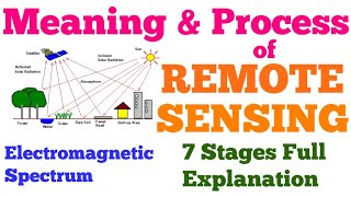
Remote sensing is the science and art of acquiring information about an object, area, or phenomenon without making physical contact with it, primarily through the detection and measurement of electromagnetic radiation. This section outlines the fundamental concepts and components essential for understanding remote sensing.
Key Components of Remote Sensing
- Energy Source or Illumination: Electromagnetic energy is essential for observing the target.
- Atmosphere: The medium through which radiation travels, affecting the signal received.
- Target: The object or area being observed and analyzed.
- Sensor: Devices that detect and record reflected or emitted energy from the target.
- Platform: The vehicle on which sensors are mounted (e.g., satellites, aircraft).
- Data Transmission and Processing: Mechanisms for converting raw sensor data into usable information.
- End Users and Interpretation: Stakeholders utilize the processed data for analysis in various fields.
The understanding and application of these components are crucial for civil engineers in various projects, including urban planning, transportation networks, and disaster management.
Youtube Videos


![What is MSc Geoinformatics course? – [Hindi] – Quick Support](https://img.youtube.com/vi/QC6cEfNk1aQ/mqdefault.jpg)

Audio Book
Dive deep into the subject with an immersive audiobook experience.
Principle of Remote Sensing
Chapter 1 of 3
🔒 Unlock Audio Chapter
Sign up and enroll to access the full audio experience
Chapter Content
Remote sensing works on the principle that all objects reflect, absorb, or emit electromagnetic energy in a predictable manner depending on their physical and chemical properties.
Detailed Explanation
This chunk explains the fundamental principle behind remote sensing. Every object interacts with electromagnetic energy, which includes light, heat, and other types of energy. Depending on their specific physical and chemical traits, objects will either reflect this energy (like a mirror), absorb it (like a sponge), or emit it (like a heat lamp). Understanding these interactions is crucial for effectively using remote sensing technologies to gather data about those objects.
Examples & Analogies
Think of remote sensing like using a camera in different lighting conditions. When you point your camera at a colorful painting, the colors you see depend on how the light reflects off the paint (reflection), how much light is absorbed by the paint (absorption), and if the paint emits any light of its own (like glow-in-the-dark paint). Similarly, remote sensors detect how different materials interact with different types of light and other electromagnetic waves.
Definition of Remote Sensing
Chapter 2 of 3
🔒 Unlock Audio Chapter
Sign up and enroll to access the full audio experience
Chapter Content
Remote sensing is defined as the process of acquiring data and information about physical objects or areas from a distance, typically from aircraft or satellites, by detecting the energy that is reflected from Earth.
Detailed Explanation
In this chunk, we learn that remote sensing allows us to gather information from far away without directly interacting with the objects being studied. This is usually accomplished using high-flying aircraft or satellites. They capture data by measuring the electromagnetic energy that is reflected from the Earth's surface back to the sensor. This method is beneficial because it allows us to observe large areas efficiently, reducing the need for ground surveys.
Examples & Analogies
Imagine trying to celebrate a surprise birthday party for a friend by monitoring their location through a drone instead of following them around in a car. The drone captures photos and video from above, piecing together information about where they are without having any direct contact. In the same way, remote sensing uses aerial technology to collect data from a distance.
Components of Remote Sensing
Chapter 3 of 3
🔒 Unlock Audio Chapter
Sign up and enroll to access the full audio experience
Chapter Content
- Energy Source or Illumination: Provides electromagnetic energy to the target.
- Atmosphere: The medium through which radiation passes.
- Target: The object or area being observed.
- Sensor: A device that detects and records the reflected/emitted energy.
- Platform: The vehicle (airborne or spaceborne) on which the sensor is mounted.
- Data Transmission and Processing: Converts raw data into usable images.
- End Users and Interpretation: For analysis and application in various fields.
Detailed Explanation
This chunk outlines the essential components that make up a remote sensing system. First is the energy source, which can be sunlight or an artificial source that illuminates the target area. The atmosphere is crucial because it can affect how this energy travels. The actual target is what you are observing, such as land or water. A sensor captures the energy reflected or emitted by this target. This sensor is mounted on a platform, which can be satellites in space or aircraft flying in the sky. Once the sensor collects raw data, it undergoes processing to convert it into images that are easier to use. Finally, end users—scientists, engineers, and others—interpret these processed images for practical applications.
Examples & Analogies
Consider it like baking a cake. First, you need your ingredients (energy source), which might be flour and sugar. The oven represents the atmosphere, providing heat that helps the cake bake. The cake batter is the target—the object of our culinary efforts. A thermometer checks if the cake is done (the sensor) while it’s in the oven mounted on a rack (the platform). After baking, you may decorate the cake before serving it (data processing), and then friends and family can enjoy and assess your creation (end users and interpretation). Each component plays a vital role in achieving the final outcome.
Key Concepts
-
Remote Sensing: A technique to gather information from a distance without contact.
-
Electromagnetic Energy: Energy emitted or reflected which allows remote sensing.
-
Sensor: Devices used to collect data about targeted objects or areas.
-
Data Processing: The transformation of raw sensor data into usable information for interpretation.
Examples & Applications
Using satellite imagery to assess deforestation over large forest areas.
Employing drones to monitor construction sites for progress and compliance.
Memory Aids
Interactive tools to help you remember key concepts
Rhymes
Remote sensing, what a find, no need to go where eyes are blind!
Stories
Once in a busy city, a town planner used satellites to watch growth from above, without needing to stand in traffic. This is how remote sensing helped them make informed decisions!
Memory Tools
Remember the acronym 'PETRIDE' for remote sensing components: Platform, Energy Source, Target, Radiation, Interpretation, Data Processing, End Users.
Acronyms
EMR
Energy
Measurement
Reflection – the keys to remote sensing!
Flash Cards
Glossary
- Remote Sensing
The process of acquiring data and information about physical objects or areas from a distance, typically using sensors on aircraft or satellites.
- Electromagnetic Energy
Energy in the form of electromagnetic waves, including visible light, infrared, and radio waves.
- Sensor
A device that detects and records the reflected or emitted energy from a target.
- Platform
The vehicle (airborne or spaceborne) on which the sensor is mounted.
- Data Processing
The techniques used to convert raw sensor data into usable information or images.
Reference links
Supplementary resources to enhance your learning experience.