
Remote Sensing for Smart Cities and Infrastructure
Enroll to start learning
You’ve not yet enrolled in this course. Please enroll for free to listen to audio lessons, classroom podcasts and take practice test.
Interactive Audio Lesson
Listen to a student-teacher conversation explaining the topic in a relatable way.
Urban Growth Monitoring
🔒 Unlock Audio Lesson
Sign up and enroll to listen to this audio lesson

Let's start with urban growth monitoring. Can anyone explain why this is an important aspect of urban planning?

It's important because cities are expanding quickly, and we need to manage that growth effectively.
Exactly! Remote sensing helps us monitor this expansion by analyzing satellite images over time. We look for evidence of unplanned developments. Can someone give an example of what we might find?

We might see new buildings popping up in areas that weren't developed before!
Correct! This ability to compare images over time is crucial for planning. Remember the acronym 'PRACTICE' to think about what we do: Population pressure, Resource allocation, Area monitoring, Construction estimates, Traffic prediction, Infrastructure mapping, and Environmental impact.

That's a good way to remember it. So, we can track changes and then make plans based on those findings?
Exactly! In summary, monitoring urban growth helps us understand how cities evolve and where we need to direct our planning efforts.
Infrastructure Asset Mapping
🔒 Unlock Audio Lesson
Sign up and enroll to listen to this audio lesson

Next, let's discuss infrastructure asset mapping. Why do you think it's essential for cities to map their infrastructure using remote sensing?

To keep track of all the roads, bridges, and utilities they have, right?
That's right! Mapping allows us to have an accurate inventory of physical assets. For example, using satellite data we can assess the condition of roads and railways. Does anyone know what kind of approach might be used for utilities mapping?
We could use LiDAR data to map out power lines and pipelines.
Exactly! LiDAR provides detailed elevation data that is vital for infrastructure planning. Think of the acronym 'MAPS': Mapping assets, Assessing conditions, Planning maintenance, and Saving costs.
That's helpful! So having accurate maps helps ensure everything runs smoothly in urban areas.
Yes! By knowing exactly what we have, we can better manage our resources.
Monitoring Construction Progress
🔒 Unlock Audio Lesson
Sign up and enroll to listen to this audio lesson
Finally, let's examine how remote sensing is used to monitor construction progress. Why might satellite data be beneficial in this area?
It can show us if construction is on schedule or if there are delays.
Exactly! High-resolution drone imagery helps track daily or weekly progress. Can anyone think of other benefits of using remote sensing in construction?
We can identify if the work is deviating from the original plans!
Yes! Monitoring site health is crucial as well. You can remember this with the acronym 'CLEAR': Construction progress, Location checks, Evaluation against plans, Assessment of safety, and Resources tracking.
That's a good summary! It helps in managing construction efficiently.
Precisely! Monitoring allows for timely interventions and ensures the success of urban projects.
Introduction & Overview
Read summaries of the section's main ideas at different levels of detail.
Quick Overview
Standard
Remote sensing provides essential data for urban growth monitoring, infrastructure asset mapping, and construction progress tracking, playing a vital role in the development of smart cities. By utilizing satellite and drone imagery, urban planners can effectively manage resources and address challenges related to rapid urbanization.
Detailed
Remote Sensing for Smart Cities and Infrastructure
Remote sensing is revolutionizing how urban planners and civil engineers approach the development of smart cities and infrastructure. The integration of satellite and aerial imagery into urban management processes facilitates a range of applications:
Key Applications
- Urban Growth Monitoring: Utilizing temporal satellite imagery to monitor unplanned urban expansion, assess population pressure, and prevent encroachment on vital areas.
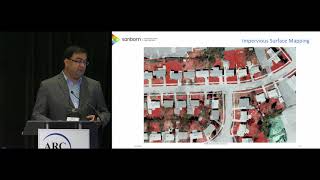
- Infrastructure Asset Mapping: Comprehensive mapping of critical infrastructure such as roads, railways, bridges, utilities, and green spaces to aid in informed decision-making.
- Monitoring Construction Progress: High-resolution imagery from drones and satellites allows for the tracking of daily or weekly construction activities, helping in identifying deviations from plans and estimating material movement and site health.
These applications underscore the significance of remote sensing technologies as tools for sustainable urban management and infrastructure development within smart cities.
Youtube Videos
Audio Book
Dive deep into the subject with an immersive audiobook experience.
Role of Remote Sensing in Urban Development
Chapter 1 of 4
🔒 Unlock Audio Chapter
Sign up and enroll to access the full audio experience
Chapter Content
Remote sensing is playing a vital role in the planning, design, and maintenance of smart cities and civil infrastructure.
Detailed Explanation
Remote sensing provides crucial data that helps city planners and civil engineers understand and manage urban areas effectively. It includes information about land use, infrastructure condition, and environmental factors. By analyzing satellite images and other remote sensing data, planners can make informed decisions about where to build new roads, parks, or utilities to improve the quality of life for residents.
Examples & Analogies
Think of remote sensing as a bird's-eye view of a city, helping city planners see how land is being used from high above. This perspective allows them to spot problems like overcrowding or poorly planned areas, similar to how a coach might analyze a game from the stands to strategize better plays.
Urban Growth Monitoring
Chapter 2 of 4
🔒 Unlock Audio Chapter
Sign up and enroll to access the full audio experience
Chapter Content
Tracking unplanned expansion, population pressure, and encroachment using temporal satellite imagery.
Detailed Explanation
Urban growth monitoring involves using satellite images taken over time to observe how a city expands. This process helps identify areas where development is happening unexpectedly, such as informal settlements or urban sprawl. By understanding these patterns, governments can plan infrastructure and services needed to support the growing population, ensuring sustainable development.
Examples & Analogies
Imagine a gardener watching a plant grow over time. By observing how quickly leaves expand and where new shoots sprout, the gardener can make decisions about water and nutrients. Similarly, urban planners observe the growth of a city to make timely decisions about roads, housing, and public services.
Infrastructure Asset Mapping
Chapter 3 of 4
🔒 Unlock Audio Chapter
Sign up and enroll to access the full audio experience
Chapter Content
Mapping of:
- Roads, railways, bridges
- Utilities (power lines, water supply)
- Green and open spaces
Detailed Explanation
Infrastructure asset mapping involves creating detailed maps of different infrastructure elements in a city, from transportation networks like roads and railways to utilities such as water supply and power lines. Remote sensing enables the collection of this data efficiently. It helps maintain and monitor these assets, ensuring they are in good condition and can serve the community effectively.
Examples & Analogies
Think of an architect with a blueprint of a building. The blueprint shows every detail, from the walls to electrical lines. Similarly, infrastructure asset mapping acts like a city’s blueprint, helping planners and engineers keep track of what exists, where it is located, and if it needs maintenance.
Monitoring Construction Progress
Chapter 4 of 4
🔒 Unlock Audio Chapter
Sign up and enroll to access the full audio experience
Chapter Content
Using high-resolution drone imagery and satellite data to:
- Track daily or weekly construction activity.
- Identify deviations from construction plans.
- Estimate material movement and site health.
Detailed Explanation
Monitoring construction progress with remote sensing tools aids in keeping projects on schedule and within budget. High-resolution images from drones and satellites provide updates on the status of construction activities, allowing managers to quickly see if everything is going according to plan or if there are unexpected changes. This practice enhances transparency and accountability in large construction projects.
Examples & Analogies
Consider a chef following a complex recipe. By regularly checking the dish's progress, they can make adjustments if something isn’t cooking right. Similarly, project managers use remote sensing to ensure construction is on track, adjusting plans as needed based on the information they receive.
Key Concepts
-
Urban Growth Monitoring: The process of observing and analyzing urban expansion using remote sensing technologies.
-
Infrastructure Asset Mapping: Utilizing remote sensing data to accurately inventory and assess city infrastructure.
-
Monitoring Construction Progress: The ability to track construction activities and ensure adherence to schedules through satellite and aerial imagery.
Examples & Applications
Using satellite imagery to identify unauthorized construction in urban areas.
Mapping utility lines and assessing their condition using LiDAR data.
Memory Aids
Interactive tools to help you remember key concepts
Rhymes
In the city's plot, we take a shot, to see the changes that are fought.
Stories
Imagine a city that grew overnight; planners use satellites to see what's right. They track the growth and make it tight, ensuring that our urban future's bright!
Memory Tools
Remember 'MICE' for urban planning: Monitor, Inventory, Conduct assessments, Evaluate progress.
Acronyms
'CAMP' for construction monitoring
Check progress
Analyze delays
Map deviations
Predict outcomes.
Flash Cards
Glossary
- Urban Growth
Expansion and development of urban areas, often monitored to ensure planned growth.
- Infrastructure Asset Mapping
The process of creating maps that depict a city’s infrastructure resources, such as roads and utilities.
- Construction Monitoring
The process of tracking the progress of construction projects using tools like satellite imagery.
- Remote Sensing
The acquisition of information about an area or object from a distance, typically through satellite or aerial imagery.
Reference links
Supplementary resources to enhance your learning experience.