
Microwave and Radar Remote Sensing
Enroll to start learning
You’ve not yet enrolled in this course. Please enroll for free to listen to audio lessons, classroom podcasts and take practice test.
Interactive Audio Lesson
Listen to a student-teacher conversation explaining the topic in a relatable way.
Introduction to Microwave Remote Sensing
🔒 Unlock Audio Lesson
Sign up and enroll to listen to this audio lesson

Today we will discuss Microwave and Radar Remote Sensing, particularly focusing on Synthetic Aperture Radar, or SAR. Can anyone tell me what they think the significance of using radar waves for remote sensing is?

Is it because radar can see through clouds?
Exactly! Radar can penetrate clouds and work in any weather condition, which is a big advantage over optical sensors. SAR is used for capturing data regardless of cloud cover.

That sounds really useful! How does SAR actually work?
SAR uses the motion of the sensor to capture high-resolution images. Think of it as creating a larger aperture artificially through movement. Remember the acronym **SYN**: 'S' for Synthetic, 'Y' for Your platform, and 'N' for Night or day operation.

So, we can use it any time, even at night?
Exactly! SAR can function day or night which makes it invaluable for monitoring situations such as floods or infrastructure damage.
Applications of SAR in Civil Engineering
🔒 Unlock Audio Lesson
Sign up and enroll to listen to this audio lesson

Now, let's discuss the applications of SAR in civil engineering. Can anyone think of a scenario where SAR would be extremely helpful?

Maybe during a flood? It could help map how far the water has spread?
Correct! SAR allows for accurate flood mapping even during cloudy weather. Another critical use is monitoring ground deformation due to tunneling or mining. Knowing how the ground shifts can prevent catastrophic failures.
How does it measure deformation?
That's a great question! SAR uses radar signals to detect changes in distance over time. A memory aid is **DPR**: 'D' for Deformation, 'P' for Periodic measurement, and 'R' for Radar signals.
What about infrastructure changes?
Yes! Changes in infrastructure can be detected, which allows for continuous monitoring of structures. Thus, SAR provides key support in ensuring safety and compliance.
Understanding Interferometric SAR (InSAR)
🔒 Unlock Audio Lesson
Sign up and enroll to listen to this audio lesson
Next, we shift our focus to Interferometric SAR, or InSAR. Who can tell me what the main function of InSAR is?
Is it to measure changes in the shape of the Earth’s surface?
Yes, that's correct! InSAR measures small changes in surface elevation with high precision. It does this by comparing two images taken at different times.
What makes it so precise?
InSAR uses phase differences in radar waves captured in those images to detect even millimeter-scale deformations. This is vital for monitoring buildings or bridges. Remember the acronym **PDS**: 'P' for Phase differences, 'D' for Detection, and 'S' for Surface changes.
Can it help with earthquake monitoring too?
Absolutely! InSAR can analyze ground displacements after an earthquake, helping engineers assess damage and plan reconstruction effectively. Continuous monitoring gives us insights into geological activities as well.
Summary and Importance
🔒 Unlock Audio Lesson
Sign up and enroll to listen to this audio lesson
To recap, SAR and InSAR are critical tools in remote sensing, especially in civil engineering. What did we learn are some of their key features?
SAR works in any weather and can map floods.
InSAR detects very small ground movements, perfect for monitoring infrastructure.
Great! Always remember the impact these technologies can have for ensuring safety and enhancing our understanding of the environment. Each acronym we've discussed like SYN for SAR and PDS for InSAR can help you remember these concepts well.
Introduction & Overview
Read summaries of the section's main ideas at different levels of detail.
Quick Overview
Standard
This section explores the principles and applications of microwave and radar remote sensing technologies, including how Synthetic Aperture Radar (SAR) operates and its capabilities in various weather conditions. It also details Interferometric SAR (InSAR) for high-precision surface deformation monitoring, with civil engineering applications provided.
Detailed
Microwave and Radar Remote Sensing
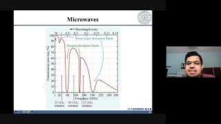
Microwave remote sensing employs microwave electromagnetic waves for the detection and analysis of surface features without concern for weather conditions, enabling day and night operations. One of the chief technologies discussed is Synthetic Aperture Radar (SAR), which can penetrate clouds, vegetation, and even soil. SAR is especially useful in civil engineering for monitoring flood extents, ground deformation, and infrastructure changes over time.
Another crucial technology is Interferometric SAR (InSAR). InSAR analyzes phase differences between SAR images taken at different times to detect even millimeter-scale deformations. It's particularly beneficial for researching structural settlements, analyzing earthquake-induced displacements, and pre-failure detection of critical structures.
Overall, these technologies advance remote sensing capabilities significantly, allowing for enhanced monitoring and management of civil engineering projects, ensuring infrastructure safety and efficiency.
Youtube Videos


Audio Book
Dive deep into the subject with an immersive audiobook experience.
Synthetic Aperture Radar (SAR)
Chapter 1 of 4
🔒 Unlock Audio Chapter
Sign up and enroll to access the full audio experience
Chapter Content
SAR sensors operate in the microwave region and can penetrate clouds, vegetation, and even soil. They can function day and night under all weather conditions.
Detailed Explanation
Synthetic Aperture Radar (SAR) is a type of radar that is specifically designed to provide high-resolution images of the Earth's surface. Unlike traditional optical sensors that rely on visible light, SAR operates in the microwave region, which allows it to see through obstacles like clouds and vegetation. This means that SAR can capture images regardless of weather conditions or time of day, making it an incredibly versatile tool for remote sensing.
Examples & Analogies
Imagine trying to take a photograph on a cloudy day with a regular camera; the image would likely be obscured. However, SAR acts like having a special camera that can see through the clouds and capture clear images, much like how some animals can see through fog or darkness. This ability makes SAR valuable for applications such as monitoring areas after a flood, where cloudy conditions might hinder traditional photography.
Applications in Civil Engineering: SAR
Chapter 2 of 4
🔒 Unlock Audio Chapter
Sign up and enroll to access the full audio experience
Chapter Content
Applications in Civil Engineering:
- Mapping flood extent during cloudy conditions.
- Monitoring ground deformation/subsidence (e.g., due to tunneling, mining, or groundwater extraction).
- Detecting changes in infrastructure over time.
Detailed Explanation
SAR technology has numerous applications in civil engineering. It can be used to map the extent of flooding when clouds obscure visibility for optical methods. Additionally, SAR can monitor ground movement, such as subsidence caused by tunneling or mining activities, which is crucial for ensuring the safety of structures. Lastly, it can detect gradual changes in infrastructure over time, allowing engineers to address potential issues before they become serious problems.
Examples & Analogies
Think of SAR as a 'health check-up' for the earth and its constructions. Just like a doctor can spot health issues through specialized scans, SAR can detect changes that indicate problems—like a building sinking or a road cracking. Engineers can use this information to make timely repairs, preventing larger failures in the future.
Interferometric SAR (InSAR)
Chapter 3 of 4
🔒 Unlock Audio Chapter
Sign up and enroll to access the full audio experience
Chapter Content
InSAR uses phase differences between SAR images to detect millimeter-scale deformations on Earth's surface.
Detailed Explanation
Interferometric SAR (InSAR) is an advanced technique that builds upon the basic SAR functionality. By taking multiple SAR images of the same area at different times, InSAR analyzes the phase differences between these images. This allows detection of very small movements of the Earth’s surface—down to millimeters—providing critical data for monitoring subsidence or structural stability.
Examples & Analogies
Imagine placing a marble on a smooth surface and applying slight pressure from one side. The marble will move only a tiny bit, but if you had a very precise ruler, you could measure that tiny movement. InSAR is like that ruler for the earth—capturing very small shifts and allowing engineers to understand what's happening beneath their feet with remarkable detail.
Applications of InSAR
Chapter 4 of 4
🔒 Unlock Audio Chapter
Sign up and enroll to access the full audio experience
Chapter Content
Applications:
- Monitoring settlement in buildings or bridges.
- Earthquake-induced ground displacement analysis.
- Pre-failure detection in dams and slopes.
Detailed Explanation
InSAR is used extensively in civil engineering for monitoring the stability of various structures. Engineers can see if buildings or bridges are settling unevenly, which might indicate potential structural failure. InSAR is also used to analyze ground displacement due to earthquakes, helping to assess damage and inform recovery efforts. Additionally, it can detect early signs of failure in critical structures like dams and slopes, providing an opportunity to mitigate risks before catastrophic events occur.
Examples & Analogies
Think of InSAR as a detective who inspects buildings with a keen eye for tiny signs of distress. Just as a detective can piece together small clues to prevent a crime, InSAR gathers minute data to warn of potential failures in buildings or slopes, ensuring people stay safe and structural integrity is maintained.
Key Concepts
-
Microwave remote sensing enables radar to function in all weather conditions.
-
Synthetic Aperture Radar (SAR) captures high-resolution images regardless of light conditions.
-
Interferometric SAR (InSAR) analyzes phase changes to measure precise surface movements.
-
Applications of SAR and InSAR enhance civil engineering practices.
Examples & Applications
SAR is used to map areas affected by floods, providing critical data for disaster management.
InSAR is utilized to monitor the deformation of structures, assessing the impact of natural events like earthquakes.
Memory Aids
Interactive tools to help you remember key concepts
Rhymes
When skies are gray and clouds are near, SAR captures data, that’s quite clear.
Stories
Imagine a diligent engineer using SAR to survey a city during a storm. The radar works beautifully, mapping out flooded streets, highlighting its resilience and efficiency even in harsh conditions.
Memory Tools
Remember SYN for SAR: 'S' for Synthetic, 'Y' for Your platform, 'N' for Night or day operation.
Acronyms
**PDS for InSAR
'P' for Phase differences
'D' for Detection
'S' for Surface changes.
Flash Cards
Glossary
- Synthetic Aperture Radar (SAR)
A radar technique that uses the motion of the radar antenna over a target region to provide finer spatial resolution than conventional beam-scanning radars.
- Interferometric SAR (InSAR)
A technique that uses the phase information of radar data to measure surface deformation and elevation changes with high precision.
- Electromagnetic Waves
Waves of the electromagnetic field propagating through space, including microwaves used in remote sensing.
- Phase Differences
Variations in the phase of a wave used in InSAR to detect differences in distance over time.
Reference links
Supplementary resources to enhance your learning experience.