
Definition and Scope of Geo-Informatics
Enroll to start learning
You’ve not yet enrolled in this course. Please enroll for free to listen to audio lessons, classroom podcasts and take practice test.
Interactive Audio Lesson
Listen to a student-teacher conversation explaining the topic in a relatable way.
Definition of Geo-Informatics
🔒 Unlock Audio Lesson
Sign up and enroll to listen to this audio lesson

Let's begin with the definition of Geo-Informatics. It is defined as the science and technology involved in the acquisition, storage, processing, analysis, visualization, and dissemination of spatial or geographically referenced data.

So, it’s all about handling spatial data? What makes it different from regular data?
Great question! Spatial data refers specifically to data that has geographic or locational attributes. Regular data may not have such references. Remember the acronym SAGE—Spatial Acquisition, Geographic Examination—to help you recall the key aspects of Geo-Informatics.

Can you give a real-world example of where this distinction is important?
Absolutely! In urban planning, knowing where buildings are located is crucial. Using Geo-Informatics tools helps planners make informed decisions based on spatial data.

So does this technology only apply to cities?
Not at all! This technology is vital for both urban and rural planning. Think about resource management in agriculture; that also heavily relies on spatial data.

Thanks, that makes sense! Can you summarize the definition again?
Sure! Geo-Informatics is all about managing spatial data through various technological processes. Remember, it's crucial for effective decision-making in many fields, especially civil engineering.
Components of Geo-Informatics
🔒 Unlock Audio Lesson
Sign up and enroll to listen to this audio lesson

Now let's delve into the components of Geo-Informatics. There are four major components to consider: Data Acquisition Systems, Data Storage and Management, Data Processing and Analysis, and Visualization and Dissemination.
What exactly do Data Acquisition Systems refer to?
Data Acquisition Systems involve methods like remote sensing, LiDAR, and field surveys. They gather the data we need for analysis. Can anyone think of a practical use for these systems?
Maybe for mapping? Like using satellite imagery?
Exactly! Satellite imagery is a prime example of data acquisition. Next, we have Data Storage and Management, which focus on how we organize and store this data securely and efficiently.
Does that involve using databases and metadata?
Correct! Metadata standards help us understand the data's context, aiding in better interpretation and use of the data. Let’s remember the mnemonic 'DAMP'—Data Acquisition, Management, Processing—for the components.
What comes after data processing?
Good follow-up! After processing, we focus on Visualization and Dissemination. This includes creating GIS-based maps and 3D models to present our findings effectively. Let’s summarize: we have data acquisition, storage and management, processing, and visualization.
Scope of Geo-Informatics
🔒 Unlock Audio Lesson
Sign up and enroll to listen to this audio lesson
Now that we understand the components, let’s talk about the scope of Geo-Informatics. The applications are vast and touch many aspects of civil engineering.
Can you give us a list of some specific areas where Geo-Informatics is used?
Certainly! Some key areas include urban and rural planning, infrastructure development, disaster management, transportation engineering, and natural resource management. Remember the acronym U-DUT-N! U for Urban planning, D for Disaster management, U for Utility mapping, T for Transportation, and N for Natural resources.
What about environmental monitoring? Is that included?
Yes, indeed! Environmental monitoring is a critical application, helping us track pollution and analyze land use changes. The versatility of Geo-Informatics in so many fields makes it incredibly valuable!
Why should we focus on Geo-Informatics going forward?
Great question! The world is increasingly reliant on spatial data for informed decision-making in various sectors. Understanding Geo-Informatics will be essential for future engineers!
Can we conclude with a summary of its importance?
Definitely! Geo-Informatics translates spatial data into actionable insights that are critical for managing urban development, natural resources, and environmental challenges.
Introduction & Overview
Read summaries of the section's main ideas at different levels of detail.
Quick Overview
Standard
This section defines Geo-Informatics as the science and technology related to spatial data acquisition, processing, and dissemination. It highlights its importance in various sectors, particularly in civil engineering, and outlines key components and applications.
Detailed
Definition and Scope of Geo-Informatics
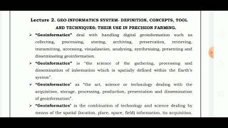
Geo-Informatics is defined as the science and technology that encompasses the acquisition, storage, processing, analysis, visualization, and dissemination of spatial or geographically referenced data. This interdisciplinary field integrates multiple components that include:
- Data Acquisition Systems: Involves techniques such as remote sensing, photogrammetry, field surveys, and LiDAR.
- Data Storage and Management: Comprises databases, metadata standards, and spatial data infrastructures.
- Data Processing and Analysis: Encompasses image processing, geostatistics, and spatial modeling.
- Visualization and Dissemination: Involves GIS-based maps, 3D models, and interactive dashboards.
The scope of Geo-Informatics is broad, inclusive of fields such as urban and rural planning, infrastructure development, disaster management, transportation engineering, environmental monitoring, and natural resource management, among others. The section underscores the critical role of Geo-Informatics in facilitating intelligent spatial decision-making, particularly in civil engineering and allied domains.
Youtube Videos


![What is MSc Geoinformatics course? – [Hindi] – Quick Support](https://img.youtube.com/vi/QC6cEfNk1aQ/mqdefault.jpg)


Audio Book
Dive deep into the subject with an immersive audiobook experience.
Definition of Geo-Informatics
Chapter 1 of 3
🔒 Unlock Audio Chapter
Sign up and enroll to access the full audio experience
Chapter Content
Geo-Informatics is the science and technology that deals with the acquisition, storage, processing, analysis, visualization, and dissemination of spatial or geographically referenced data.
Detailed Explanation
Geo-Informatics is a field focused on both the theoretical and practical aspects of working with spatial or geographic data. This means it encompasses everything from collecting data about locations on Earth to storing and analyzing that data, as well as making it possible for others to visualize and share it. Essentially, Geo-Informatics provides the tools and methodologies needed to understand where things are and how they relate to one another in physical space.
Examples & Analogies
Think of Geo-Informatics like the GPS on your smartphone. When you use an app to find directions, it uses spatial data to understand where you are and where you need to go. The app collects this geographic data, processes it, and then presents it to you visually in a way that's easy to understand.
Major Components of Geo-Informatics
Chapter 2 of 3
🔒 Unlock Audio Chapter
Sign up and enroll to access the full audio experience
Chapter Content
Geo-Informatics integrates the following major components:
• Data Acquisition Systems: Remote sensing, photogrammetry, field surveys, LiDAR.
• Data Storage and Management: Databases, metadata standards, spatial data infrastructure.
• Data Processing and Analysis: Image processing, geostatistics, spatial modeling.
• Visualization and Dissemination: GIS-based maps, 3D models, dashboards.
Detailed Explanation
This section outlines the foundational components that make up the Geo-Informatics field. First, data acquisition systems are methods used to gather geographic data, such as remote sensing (using satellites), photogrammetry (using photographs), and LiDAR (light detection). Next, data storage and management involve organizing and maintaining data in databases. After data is collected, it needs processing and analysis, which can involve statistics and modeling to extract meaningful insights. Finally, visualization and dissemination refer to the ways in which this data can be presented to users, such as through maps or dashboards, making it easy to comprehend.
Examples & Analogies
Imagine you are a chef preparing a dish. The ingredients you gather (data acquisition) need to be stored properly (data storage), mixed and cooked (data processing), and finally plated beautifully for serving (visualization). Each step is critical to ensure your final dish is not only tasty but also looks appealing to your guests.
Scope of Geo-Informatics
Chapter 3 of 3
🔒 Unlock Audio Chapter
Sign up and enroll to access the full audio experience
Chapter Content
• Urban and rural planning
• Infrastructure development
• Disaster management
• Transportation and traffic engineering
• Environmental monitoring
• Natural resource management
• Land use and land cover analysis
• Utility mapping
Detailed Explanation
The scope of Geo-Informatics touches various fields, showcasing its versatility and importance. Urban and rural planning involves using geographic data to design sustainable communities. Infrastructure development relies heavily on the mapping and analysis provided by Geo-Informatics to ensure effective construction and resource allocation. In disaster management, Geo-Informatics aids in preparing and responding to emergencies by providing spatial insights on vulnerability and risks. Transportation engineering uses these tools to analyze traffic patterns and optimize routes. Environmental monitoring helps track pollution and species distribution, while natural resource management ensures sustainable usage of resources like water and forests. Finally, utility mapping provides essential data on the positioning of essential services such as electricity and water.
Examples & Analogies
Consider a city planner designing a new neighborhood. They need to know where existing roads and utilities are located (utility mapping), how much green space to include (land use analysis), and how the new development impacts traffic patterns (transportation engineering). Geo-Informatics serves as their blueprint, allowing them to create a balanced and practical plan that enhances living conditions for residents.
Key Concepts
-
Geo-Informatics: A field dealing with the processing of spatial or geographically referenced data.
-
Components of Geo-Informatics: Include data acquisition, storage, processing, visualization, and dissemination.
-
Scope of Geo-Informatics: Encompasses various applications like urban planning, disaster management, and resource management.
Examples & Applications
Using GIS software to create a map for urban planning purposes.
Applying remote sensing data to monitor deforestation in a region.
Memory Aids
Interactive tools to help you remember key concepts
Rhymes
Geo-Informatics helps you see, how data lives in geometry!
Stories
Imagine a city planner who uses maps to decide where parks should go, using special tools that show the land with all its features—that’s Geo-Informatics!
Memory Tools
Remember the acronym SAGE—Spatial Acquisition, Geographic Examination—to connect the core concepts of Geo-Informatics.
Acronyms
DAMP
Data Acquisition
Management
Processing.
Flash Cards
Glossary
- GeoInformatics
An interdisciplinary field integrating science, engineering, and technology to process and manage spatial data.
- Data Acquisition Systems
Techniques like remote sensing and surveys for gathering spatial data.
- Data Processing
The manipulation of data to extract useful information.
- Visualization
The presentation of data in visual formats such as maps and models.
- Spatial Data
Data that contains geographical or locational attributes.
Reference links
Supplementary resources to enhance your learning experience.