
Fundamental Concepts of Spatial Data
Enroll to start learning
You’ve not yet enrolled in this course. Please enroll for free to listen to audio lessons, classroom podcasts and take practice test.
Interactive Audio Lesson
Listen to a student-teacher conversation explaining the topic in a relatable way.
Spatial vs. Non-Spatial Data
🔒 Unlock Audio Lesson
Sign up and enroll to listen to this audio lesson

Today, we will dive into the fundamental concepts of spatial data. First, can anyone tell me how we differentiate between spatial and non-spatial data?

Spatial data refers to information that has a geographic location attached to it, like coordinates.
Exactly! And how about non-spatial data?

Non-spatial data is descriptive information that links back to that location, like the population of an area.
Great! Remember this distinction: Spatial data is all about where, while non-spatial data tells us more about what. Let’s summarize: spatial = location, non-spatial = description.
Types of Spatial Data
🔒 Unlock Audio Lesson
Sign up and enroll to listen to this audio lesson

Now let's talk about the types of spatial data. Can someone tell me what vector data is?

Vector data includes points, lines, and polygons.
Correct! Can anyone give me an example of each type?

A point might represent a school, lines could represent roads, and polygons could be cities or lakes.
Well done! Now, how is raster data different from vector data?
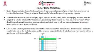
Raster data is pixel-based, used for images or grids.
Exactly! Raster data is often used in satellite imagery. Finally, who can explain attribute data?
Attribute data describes the spatial features; it's tabular information linked to those points, lines, or polygons.
Summarizing, we have vector (geometric shapes), raster (pixel grids), and attribute data (descriptive info).
Coordinate Systems and Projections
🔒 Unlock Audio Lesson
Sign up and enroll to listen to this audio lesson
Now, let’s discuss coordinate systems. Who can explain what a Geographic Coordinate System is?
It's a system that uses latitude and longitude to pinpoint locations on the Earth's surface.
Exactly! And what's a Projected Coordinate System?
It transforms the Earth's surface onto a flat plane, such as UTM.
Correct! Coordinate systems are essential for spatial accuracy. What are some examples of common datums used?
WGS84 and NAD83 are a couple of examples of reference frameworks.
Fantastic! Remember, coordinate systems help ensure we are all speaking the same geographic language. Let’s summarize: GCS for latitude and longitude, PCS for flat representations.
Introduction & Overview
Read summaries of the section's main ideas at different levels of detail.
Quick Overview
Standard
The section elaborates on the fundamental concepts of spatial data, including the differentiation between spatial and non-spatial data, the types of spatial data (vector, raster, and attribute data), and the significance of coordinate systems and projections in Geo-Informatics.
Detailed
Detailed Summary of Fundamental Concepts of Spatial Data
In Geo-Informatics, understanding spatial data is crucial for effective data analysis and interpretation. This section is divided into three main subpoints:
1.3.1 Spatial vs. Non-Spatial Data
Spatial data refers to data that has geographic or locational attributes, such as coordinates representing specific points on Earth's surface (e.g., latitude and longitude). In contrast, non-spatial data is descriptive information linked to these spatial features, providing context, such as population size or land use types.
1.3.2 Types of Spatial Data
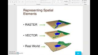
Spatial data can be categorized into three main types:
- Vector Data: This includes points (e.g., buildings), lines (e.g., roads), and polygons (e.g., lakes and administrative boundaries).
- Raster Data: This format uses a grid of pixels, typically in satellite images or digital elevation models, where each pixel represents spatial information at its location.
- Attribute Data: These are tabular details that describe the characteristics of spatial features, such as demographics or survey data.
1.3.3 Coordinate Systems and Projections
Coordinate systems are vital for accurately representing spatial data on Earth’s surface. There are two main types:
- Geographic Coordinate System (GCS): Utilizes latitude and longitude.
- Projected Coordinate System (PCS): Provides a flat depiction of the Earth, such as Universal Transverse Mercator (UTM) or State Plane Coordinates.
Datasums or reference frameworks, such as WGS84 or NAD83, ensure consistency in spatial measurements across different platforms, enhancing interoperability among diverse datasets.
Understanding these concepts is foundational for professionals in civil engineering and related fields when utilizing spatial data for planning, development, and analysis.
Youtube Videos


Audio Book
Dive deep into the subject with an immersive audiobook experience.
Spatial vs. Non-Spatial Data
Chapter 1 of 3
🔒 Unlock Audio Chapter
Sign up and enroll to access the full audio experience
Chapter Content
• Spatial Data: Data with geographic or locational attributes (e.g., coordinates, polygons)
• Non-Spatial Data: Descriptive data linked to spatial features (e.g., population, land use type)
Detailed Explanation
Spatial data refers to information that has a geographic aspect. This means it includes data points like coordinates (latitude and longitude), shapes like polygons (areas demarcated on a map), and other details that can be placed on a map. Non-spatial data, on the other hand, does not have a direct geographic component; it describes characteristics tied to locations without being inherently visual, such as population statistics linked to geographical areas or categories like land use.
Examples & Analogies
Think of a school's address as spatial data—it tells you where the school is located. The number of students attending that school, however, is non-spatial data. While the address tells you where to find it on a map, the student count gives you descriptive information about that location without geographical coordinates.
Types of Spatial Data
Chapter 2 of 3
🔒 Unlock Audio Chapter
Sign up and enroll to access the full audio experience
Chapter Content
• Vector Data: Points, lines, polygons
• Raster Data: Pixel-based, used in images and grids
• Attribute Data: Tabular information describing spatial features
Detailed Explanation
Spatial data comes in different types. Vector data represents geographic features using points, lines, and polygons. For example, a point can show a city, a line can show a road, and a polygon can represent a park. Raster data, on the other hand, consists of pixels and is used for images and grids, like digital photographs or detailed maps that show gradients (like land elevation). Finally, attribute data provides additional information about these spatial features in a table format, such as the name of a city or the population of an area.
Examples & Analogies
Imagine you are creating a game. In this game, vector data can be likened to the playable characters (represented as points) and paths (represented as lines). Raster data is like the background scenery, which is made up of many individual pixel colors. The attributes are like the character's stats (like health, speed, and skills) stored in a menu, giving you information about the characters without being part of the game map itself.
Coordinate Systems and Projections
Chapter 3 of 3
🔒 Unlock Audio Chapter
Sign up and enroll to access the full audio experience
Chapter Content
• Geographic Coordinate System (GCS): Latitude and longitude
• Projected Coordinate System (PCS): UTM, State Plane Coordinates
• Datum: WGS84,NAD83–Reference frameworks for spatial measurements
Detailed Explanation
Coordinate systems provide the framework for determining locations on the Earth. The Geographic Coordinate System (GCS) uses latitude and longitude to pinpoint locations globally. This system is useful for representing the Earth as a sphere. However, when mapping on flat surfaces, we use Projected Coordinate Systems (PCS) like UTM (Universal Transverse Mercator), which transform the spherical representation into flat coordinate grids. Datum is the reference framework used to ensure that the coordinates are accurate, like WGS84 and NAD83, which help standardize how we measure and interpret geographic data.
Examples & Analogies
Think of GCS as the global positioning system for finding coordinates anywhere in the world, like finding your friend's house. But when you print that map on paper, it becomes difficult to show the round Earth on flat pages. So, just like the way road maps use certain tools to depict those curves accurately, projected coordinate systems help represent our three-dimensional world in two-dimensional maps without too much distortion.
Key Concepts
-
Spatial Data: Data with geographic location attributes.
-
Non-Spatial Data: Descriptive information linked to spatial features.
-
Vector Data: Geometric representations of features as points, lines, and polygons.
-
Raster Data: Pixel-based spatial representation.
-
Attribute Data: Tabular data describing features.
-
Coordinate Systems: Frameworks for identifying locations on Earth.
-
Geographic Coordinate System: Latitude and longitude system.
-
Projected Coordinate System: Flat representation of spatial data.
-
Datum: Reference frameworks for spatial measurement.
Examples & Applications
An example of spatial data is a map showing the locations of hospitals in a city, using points to represent each hospital.
A raster dataset could be a satellite image of a region, where each pixel represents the land cover type.
Memory Aids
Interactive tools to help you remember key concepts
Rhymes
Spatial data's where they stay, non-spatial gives the details, hooray!
Stories
Imagine a town where every building is a point on a map. Each point has a name and information, mixing spatial data with a story of who lives there.
Memory Tools
Remember SPATIAL for 'S'patial 'P'oints 'A'res 'T'abulations 'I'n 'A'lmost 'L'ocations, showing the essence!
Acronyms
GCS = Geographic Coordinate System, where G = Geographical, C = Coordinate.
Flash Cards
Glossary
- Spatial Data
Data that has geographic or locational attributes, such as coordinates or maps.
- NonSpatial Data
Descriptive information linked to spatial features, such as population data or land use types.
- Vector Data
Data represented by points, lines, and polygons, used to represent geographic features.
- Raster Data
Pixel-based data, typically used in images and grids, where each pixel represents spatial information.
- Attribute Data
Tabular information that describes the characteristics of spatial features.
- Geographic Coordinate System (GCS)
A system that utilizes latitude and longitude for locating points on Earth's surface.
- Projected Coordinate System (PCS)
A system that represents Earth's surface in two dimensions, such as UTM.
- Datum
A reference framework used for spatial measurements, e.g., WGS84 or NAD83.
Reference links
Supplementary resources to enhance your learning experience.