
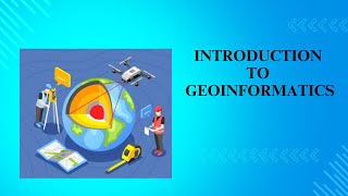
Key Technologies in Geo-Informatics
Enroll to start learning
You’ve not yet enrolled in this course. Please enroll for free to listen to audio lessons, classroom podcasts and take practice test.
Interactive Audio Lesson
Listen to a student-teacher conversation explaining the topic in a relatable way.
Geographic Information System (GIS)
🔒 Unlock Audio Lesson
Sign up and enroll to listen to this audio lesson

Today, we'll start with Geographic Information Systems, or GIS. Can anyone tell me what GIS is?

Is it a tool for mapping data?
Exactly! GIS allows users to store, analyze, and visualize spatial data. It uses layers to represent data. Does anybody know what topological modeling means?

Is that how we understand the relationships between different spatial features?
Yes! You can model how different elements interact. Remember this idea with the acronym TRP—Topology, Relationships, Processing. Let’s keep this in mind as we move to the next technology.
Global Navigation Satellite System (GNSS)
🔒 Unlock Audio Lesson
Sign up and enroll to listen to this audio lesson

Next, let’s dive into Global Navigation Satellite Systems, known as GNSS. Who can tell me some applications of GNSS?

I think it’s used in GPS for navigation?
Correct! GNSS is crucial for accurate positioning in various applications, including surveying. Think of it as a 'game-changer' in our field! Remember the phrase “Precise Positioning, Always!” to recall its importance.

So, it can help in real-time tracking too?
Absolutely! Real-time tracking is vital for many projects and operations. Great job, everyone!
Remote Sensing (RS)
🔒 Unlock Audio Lesson
Sign up and enroll to listen to this audio lesson
Now let’s explore Remote Sensing, which captures data from the Earth's surface without contact. What platforms can be used for RS?
Satellites and drones!
Good answer! Satellites and UAVs are commonly used. Remote sensing involves sensors like optical and radar. To help you remember, think of the mnemonic 'SARPO'—Satellites, Aerial, Remote, Photons, Optical.
What kind of data can we collect with this method?
Very good question! We can collect imagery, thermal data, and much more. This is crucial for monitoring environmental changes. Keep engaging with these concepts!
Photogrammetry and LiDAR
🔒 Unlock Audio Lesson
Sign up and enroll to listen to this audio lesson
Let’s wrap this up by discussing Photogrammetry and LiDAR. How do you think these technologies work?
I think photogrammetry uses photos to create maps, right?
Yes! It derives measurements from aerial images. On the other hand, LiDAR uses lasers to map the land's elevation accurately. To remember the difference, remember 'Photo = Light' for photogrammetry and 'Laser = Depth' for LiDAR. Can anyone give an application for LiDAR?
Maybe creating digital elevation models?
Exactly! Digital elevation models are vital for various engineering solutions. Well done today, everyone! Remember to use 'PLD'—Photogrammetry, LiDAR, Digital Elevation—as a mnemonic to recall these technologies!
Introduction & Overview
Read summaries of the section's main ideas at different levels of detail.
Quick Overview
Standard
In Geo-Informatics, technologies such as Geographic Information Systems (GIS), Global Navigation Satellite Systems (GNSS), Remote Sensing (RS), and advanced measurement techniques like photogrammetry and LiDAR are critical. These technologies aid in the collection, processing, and visualization of spatial data, enhancing decision-making in civil engineering and related fields.
Detailed
Key Technologies in Geo-Informatics
Geo-Informatics leverages various advanced technologies integral to spatial data management and analysis. This section delves into four primary technologies:
1. Geographic Information System (GIS)
GIS software enables the storage, analysis, and visualization of geographic data, represented in layers. It allows for complex topological modeling and spatial queries that support effective decision-making.
2. Global Navigation Satellite System (GNSS)
GNSS provides satellite-based navigation, essential for accurate positioning and mapping applications such as surveying and real-time tracking, improving the precision of spatial data.
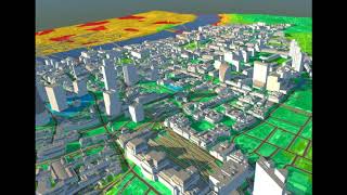
3. Remote Sensing (RS)
RS involves collecting Earth surface data from a distance, using platforms like satellites and UAVs equipped with various sensors (optical, radar, thermal). This technology facilitates substantial data collection without physical contact with the subject.
4. Photogrammetry and LiDAR
Photogrammetry derives spatial information from aerial photographs, while LiDAR uses laser technology to create detailed elevation maps and point clouds, offering an efficient means of capturing high-resolution spatial data.
These technologies play a pivotal role in various applications, including infrastructure planning, environmental monitoring, and land management, significantly enhancing the capabilities of civil engineering.
Youtube Videos


![What is MSc Geoinformatics course? – [Hindi] – Quick Support](https://img.youtube.com/vi/QC6cEfNk1aQ/mqdefault.jpg)


Audio Book
Dive deep into the subject with an immersive audiobook experience.
Geographic Information System (GIS)
Chapter 1 of 4
🔒 Unlock Audio Chapter
Sign up and enroll to access the full audio experience
Chapter Content
• Software and tools for storing, analyzing, and visualizing spatial data
• Layer-based data representation
• Topological modeling and spatial queries
Detailed Explanation
A Geographic Information System (GIS) is a powerful set of software and tools that help in managing spatial data. It allows users to store large amounts of geographic information and carry out analyses to make informed decisions. The data in GIS is often represented in layers, similar to how a map might display different features like roads, rivers, and terrain. Additionally, GIS facilitates topological modeling, which is the representation of spatial relationships among data elements (like adjacency and connectivity), making it easier to perform spatial queries—questions about the location and characteristics of data points.
Examples & Analogies
Imagine GIS as a digital version of an onion, where each layer represents different types of information. For instance, in urban planning, one layer might show roads, another layer displays zoning information, and yet another layer could illustrate vegetation. By peeling back these layers, planners can make spatial decisions about where to build parks or schools.
Global Navigation Satellite System (GNSS)
Chapter 2 of 4
🔒 Unlock Audio Chapter
Sign up and enroll to access the full audio experience
Chapter Content
• Satellite-based navigation and positioning (e.g., GPS, GLONASS, Galileo)
• Applications: Surveying, mapping, real-time tracking
Detailed Explanation
The Global Navigation Satellite System (GNSS) comprises several satellite systems, including GPS (the most commonly known), GLONASS, and Galileo, which provide exact positioning and navigation capabilities anywhere on Earth. GNSS is essential for various applications, particularly in surveying and mapping, where precise location data is crucial. Furthermore, it enables real-time tracking of items or individuals, which is pivotal in logistics and transportation management.
Examples & Analogies
Think of GNSS like a series of enormous lights shining down on the Earth from space. If you are holding a special instrument (like a GPS receiver), you can pinpoint your exact location anywhere in the world, much like how a lighthouse helps sailors find their way in dark waters.
Remote Sensing (RS)
Chapter 3 of 4
🔒 Unlock Audio Chapter
Sign up and enroll to access the full audio experience
Chapter Content
• Acquisition of Earth surface data without physical contact
• Platforms: Satellites (IRS, Landsat), UAVs, aircrafts
• Sensors: Optical, radar, thermal, hyperspectral
Detailed Explanation
Remote Sensing (RS) refers to the technique of gathering information about the Earth's surface without physically touching it. This is accomplished through various platforms such as satellites (like IRS and Landsat) or UAVs (drones). The data is collected using different types of sensors that can capture various wavelengths of light, including optical, radar, and thermal imaging. This capability allows for diverse applications, from environmental monitoring to urban planning.
Examples & Analogies
Imagine using a camera to take photographs from a high vantage point, like a hot air balloon. You can capture images of vast landscapes below without ever stepping foot on the ground. Similarly, remote sensing uses satellites and drones to 'look' at the Earth, providing valuable data for analyzing land use, monitoring forests, and assessing agricultural conditions.
Photogrammetry and LiDAR
Chapter 4 of 4
🔒 Unlock Audio Chapter
Sign up and enroll to access the full audio experience
Chapter Content
• Photogrammetry: Deriving measurements from aerial photographs
• LiDAR (Light Detection and Ranging): Laser-based elevation mapping, point cloud generation
Detailed Explanation
Photogrammetry is the method of obtaining reliable measurements through photographs taken from the air, which allows for the creation of precise measurements of objects and Earth surfaces. It is especially useful in mapping and surveying efforts. LiDAR, or Light Detection and Ranging, enhances this capability by using laser beams to measure distances to the Earth. It generates point clouds, which are detailed 3D representations of the terrain or objects on the ground. This technology is known for its accuracy and ability to capture complex topographies.
Examples & Analogies
Consider photogrammetry as trying to measure the height of a tree by taking pictures of it from different angles and calculating the distances. In contrast, LiDAR is like having a super high-tech ruler that uses lasers to 'bounce' off the tree and back to the sensor, giving you extremely accurate measurements of its height and the surrounding landscape.
Key Concepts
-
Geographic Information Systems (GIS): A system designed to capture, store, manipulate, analyze, manage, and present spatial or geographic data.
-
Global Navigation Satellite System (GNSS): A satellite system that provides autonomous geo-spatial positioning with global coverage.
-
Remote Sensing (RS): The acquisition of information about the Earth’s surface through satellite or aerial imagery without physical contact.
-
Photogrammetry: The art and science of obtaining reliable measurements through the process of recording, measuring, and interpreting photographic images.
-
LiDAR (Light Detection and Ranging): A remote sensing method that uses light in the form of a pulsed laser to measure variable distances to the Earth.
Examples & Applications
GIS can be used to create maps for urban planning that layer information on demographics, transportation, and environmental features.
GNSS is critical for precise surveying in construction projects, where accurate positioning reduces errors and enhances efficiency.
Remote sensing enables environmental monitoring, such as tracking deforestation or changes in land use over time.
LiDAR is employed to create 3D models of terrain for flood risk analysis, providing visualization and assessment of flood-prone areas.
Memory Aids
Interactive tools to help you remember key concepts
Rhymes
When mapping needs some flair, use GIS, it’s beyond compare!
Stories
A young cartographer, named Leo, discovered how GIS helped him visualize city plans, leading him to become the city’s leading planner!
Memory Tools
Remember GNSS by saying, 'Globally Navigating, Satellite Signals.'
Acronyms
PLD for Photogrammetry, LiDAR, Data—capture maps and make them matter!
Flash Cards
Glossary
- Geographic Information System (GIS)
A framework for gathering, managing, and analyzing spatial and geographic data.
- Global Navigation Satellite System (GNSS)
Satellite-based systems for obtaining accurate position and timing information.
- Remote Sensing (RS)
The acquisition of information about an object or phenomenon without making physical contact.
- Photogrammetry
The science of making measurements from photographs, often used for mapping.
- LiDAR
Light Detection and Ranging; a surveying method that measures distance to a target using laser light.
Reference links
Supplementary resources to enhance your learning experience.