
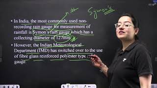
Rain Gauge Network in India
Enroll to start learning
You’ve not yet enrolled in this course. Please enroll for free to listen to audio lessons, classroom podcasts and take practice test.
Interactive Audio Lesson
Listen to a student-teacher conversation explaining the topic in a relatable way.
Understanding Rain Gauge Density
🔒 Unlock Audio Lesson
Sign up and enroll to listen to this audio lesson

Today, we're going to learn about the density of rain gauge stations in India. Can anyone explain why the density of these stations might vary?

Maybe it depends on how much it rains in that area?
Exactly! The rain gauge density does vary based on rainfall intensity. For instance, in plain areas, we have one gauge for every 520 square kilometers.

What about hilly areas?
Good question! In hilly areas, it's much denser—one for every 190 square kilometers. Can anyone think of why that is?

Probably because rain patterns are different there?
Yes! Different terrains can experience different rainfall patterns, which means we need more stations to gather accurate data.
What do we mean by 'homogeneity' in this context?
Hydrological homogeneity refers to areas that have similar rainfall patterns. Monitoring such areas helps us understand their water resource behavior effectively.
Let's summarize. The IMD sets specific norms for rain gauge station density based on geography, ensuring that our rainfall data collection is reliable and effective.
Importance of Coverage in Rain Gauge Networks
🔒 Unlock Audio Lesson
Sign up and enroll to listen to this audio lesson

Now that we understand density, why do you think balanced spatial distribution of rain gauges is essential?

To make sure all regions are getting enough data?
Exactly! If some areas are under-represented, then critical rainfall data could be missed, which is vital for effective water resource management.
What about river basins?
Great point! Coverage across river basins ensures we can manage water efficiently, especially since rainfall impacts those regions directly.
So, more gauges help us predict floods better?
Absolutely! More accurate data helps improve flood and drought forecasting, which is crucial for disaster management.
To recap, a well-planned rain gauge network with balanced distribution and sufficient coverage leads to better rainfall monitoring and management strategies.
Introduction & Overview
Read summaries of the section's main ideas at different levels of detail.
Quick Overview
Standard
In India, the distribution of rain gauge stations depends on terrain and rainfall intensity, governed by the norms set by the India Meteorological Department (IMD). Specifically, the density of stations in plain, hilly, and heavy rainfall areas ensures adequate spatial coverage for effective hydrological management.
Detailed
Rain Gauge Network in India
The efficiency and effectiveness of rainfall data collection in India are significantly influenced by the structure of its rain gauge network. The density of rain gauge stations is shaped by two principal factors: the terrain of the area and the importance of monitoring rainfall in that specific region. The guidelines established by the India Meteorological Department (IMD) outline the necessary density of these stations:
- For plain areas, the recommended standard is one station per 520 km².
- In hilly areas, a higher density of one station per 190 km² is mandated due to the variations in rainfall patterns.
- For regions experiencing heavy rainfall, a greater density of gauges is deemed necessary to ensure precise measurements.
Moreover, the planning of the rain gauge network takes into account:
- The hydrological homogeneity of the region, ensuring similar rainfall responses are monitored together.
- The need for a balanced spatial distribution to enhance data reliability across various geographical features.
- Significant coverage across river basins and catchments, thereby aiding in comprehensive water resource management.
Youtube Videos


Audio Book
Dive deep into the subject with an immersive audiobook experience.
Density of Rain Gauge Stations
Chapter 1 of 2
🔒 Unlock Audio Chapter
Sign up and enroll to access the full audio experience
Chapter Content
The density of rain gauge stations depends on terrain and importance:
- IMD Norms:
- Plain areas: 1 station per 520 km²
- Hilly areas: 1 station per 190 km²
- Heavy rainfall areas: Higher density required
Detailed Explanation
The density of rain gauge stations is crucial for accurate rainfall measurement in different terrains. The India Meteorological Department (IMD) has established norms to ensure effective coverage across various regions:
- In plain areas, there should be one rain gauge station for every 520 square kilometers. This ensures that rainfall data is reliably collected over large flat lands where precipitation can be more evenly distributed.
- In hilly areas, where the topography can cause significant variations in rainfall, the norm is denser, with one station every 190 square kilometers. This helps to capture local climatic conditions more accurately.
- For areas that experience heavy rainfall, an even higher density of stations is required to monitor the precipitation effectively, as these regions can have extreme weather conditions that significantly impact water resource management.
Examples & Analogies
Think of the rain gauge stations like gas stations on a highway. If you are driving through a flat landscape, you might only need a station every 10 miles because the terrain is the same, and you can find fuel easily. However, if you're driving through hilly areas, you may need gas stations more frequently because the drive can be unpredictable; some areas might have more hills and curves that make it harder to find fuel. Similarly, rain gauges help ensure that no area is left without the vital weather data they need.
Network Planning Considerations
Chapter 2 of 2
🔒 Unlock Audio Chapter
Sign up and enroll to access the full audio experience
Chapter Content
Network Planning:
- Based on hydrological homogeneity
- Need for balanced spatial distribution
- Coverage across river basins and catchments
Detailed Explanation
The planning of the rain gauge network is critical for the effective collection of rainfall data. Several factors influence how this network is organized:
- Hydrological homogeneity refers to areas that have similar rainfall characteristics. The network is designed to ensure that similar regions can be effectively monitored together, enabling better data comparison and analysis.
- A balanced spatial distribution is essential to avoid clusters of stations in some areas while leaving others unmonitored. This approach ensures that diverse climatic conditions across various regions are well represented.
- Additionally, coverage across river basins and catchments is necessary to understand the rainfall effects on water flows and resources in these critical areas. It helps in planning for flood management and irrigation systems by providing timely data.
Examples & Analogies
Imagine you are organizing a community watch program. You wouldn't want all the volunteers to be concentrated in one neighborhood while others are left unmonitored. By spreading them out according to the characteristics of each neighborhood, such as activity levels or crime rates, you ensure a more effective community safety net. Similarly, rain gauge networks are like community watch programs for rainfall; they need to be spread out evenly and strategically to monitor and respond to water resource needs.
Key Concepts
-
Rain Gauge Network: A systematic arrangement of rain gauges designed to collect rainfall data across varied terrains.
-
Density of Stations: Refers to how closely spaced rain gauges are in an area, crucial for effective monitoring.
-
Hydrological Homogeneity: Areas with similar rainfall patterns warrant specific planning for gauge placement.
-
IMD Criteria: Guidelines that dictate where and how many rain gauges should be installed based on geographical importance.
Examples & Applications
In flat areas like the Indo-Gangetic plain, the gauge density is lower because rainfall patterns are relatively uniform.
In the Western Ghats, which receive heavy rainfall, a greater concentration of gauges is required to accurately measure precipitation.
Memory Aids
Interactive tools to help you remember key concepts
Rhymes
For rain to gauge, we need a stage, in hilly plains gauge density is key, 190 in height, 520 with sight!
Stories
Once upon a time, in a land of rain, the IMD placed gauges, like seeds in a grain. In plains far and wide, they spaced out with care, while in hills closely gathered, to measure the air!
Memory Tools
Remember the acronym G.A.U.G.E.: Geography Adjusted Uniform Gauge Elements. It helps recall that gauges adjust based on geographical features like hills and plains.
Acronyms
The word **RAIN**
Reachability (for coverage)
Accuracy (in measurements)
Importance (of data)
Network (of stations)!
Flash Cards
Glossary
- Rain Gauge
An instrument used to measure the amount of rain that has fallen.
- Density
Refers to the number of rain gauges within a given area, impacting the reliability of rainfall data.
- Hydrological Homogeneity
A condition where areas exhibit similar rainfall patterns, making it easier to analyze water resource behaviors.
- IMD Norms
Standards set by the India Meteorological Department for the density of rain gauges based on regional geography.
Reference links
Supplementary resources to enhance your learning experience.