
Use of Remote Sensing and GIS in Rainfall Analysis
Enroll to start learning
You’ve not yet enrolled in this course. Please enroll for free to listen to audio lessons, classroom podcasts and take practice test.
Interactive Audio Lesson
Listen to a student-teacher conversation explaining the topic in a relatable way.
Introduction to Remote Sensing
🔒 Unlock Audio Lesson
Sign up and enroll to listen to this audio lesson

Today, we're going to dive into remote sensing. Can anyone tell me what remote sensing means?

Isn’t it about collecting data from a distance, like using satellites?
Exactly! Remote sensing is all about obtaining information from a distance. For rainfall analysis, we use satellites to gather data on precipitation. This includes systems like INSAT and TRMM.

How is this data useful in rainfall analysis?
Great question! The data helps in mapping the spatial distribution of rainfall and can assist in planning water resources more effectively.
GIS Integration
🔒 Unlock Audio Lesson
Sign up and enroll to listen to this audio lesson

Once we have our rainfall data from satellites, we need to use a GIS. What do you think GIS does?

It helps in visualizing data on maps?
Absolutely! GIS allows us to create spatial maps that show rainfall distribution in different regions. This helps in analyzing patterns and planning strategies for water resource management.

Can GIS also help with predicting floods?
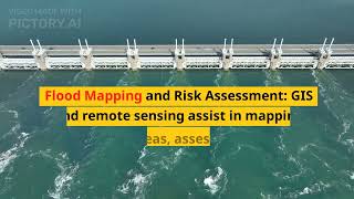
Yes! GIS can analyze rainfall data to assess flood risks by understanding catchment areas. It helps in identifying regions that may experience flooding.
Applications in Flood and Drought Risk Assessment
🔒 Unlock Audio Lesson
Sign up and enroll to listen to this audio lesson
Now let's talk about how remote sensing and GIS are applied in real-life scenarios. Can anyone give me an example of how these tools are used in environmental management?
They might be used to create flood risk maps?
Correct! Using the rainfall data, we can create those maps to help communities prepare for floods. What about droughts?
We can analyze rainfall deficits to identify areas at risk of drought.
Yes! This analysis is crucial for timely interventions in water resource management, ensuring that regions facing drought can be supported.
Introduction & Overview
Read summaries of the section's main ideas at different levels of detail.
Quick Overview
Standard
The utilization of remote sensing technologies, such as satellite systems like INSAT and TRMM, combined with GIS tools, enables efficient spatial mapping, catchment planning, and assessment of flood and drought risks in rainfall analysis.
Detailed
Use of Remote Sensing and GIS in Rainfall Analysis
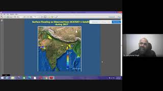
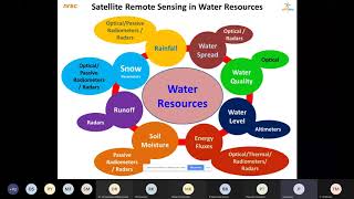
In the context of rainfall analysis in India, remote sensing technology plays a crucial role by providing satellite rainfall estimates collected from various satellite systems like INSAT, METEOSAT, TRMM, and GPM. These satellite-derived data facilitate the integration with Geographic Information Systems (GIS), which allows for efficient spatial mapping of rainfall distribution across various regions. The synergy of remote sensing and GIS tools is significant for effective catchment-wide planning, enabling engineers and policymakers to better assess flood risks and drought conditions. This integration helps in creating detailed rainfall distribution maps, understanding hydrological impacts, and improving water resource management strategies.
Youtube Videos

Audio Book
Dive deep into the subject with an immersive audiobook experience.
Satellite Rainfall Estimates
Chapter 1 of 2
🔒 Unlock Audio Chapter
Sign up and enroll to access the full audio experience
Chapter Content
• Satellite rainfall estimates from:
– INSAT, METEOSAT, TRMM, GPM
Detailed Explanation
Satellite rainfall estimates are derived from various satellites like INSAT (Indian National Satellite System), METEOSAT (Meteorological Satellite), TRMM (Tropical Rainfall Measuring Mission), and GPM (Global Precipitation Measurement). These satellites utilize advanced technologies to detect and measure rainfall from space, providing valuable data that can complement traditional ground-based measurements.
Examples & Analogies
Imagine trying to find out the amount of rain in your entire school from your classroom window. You can see your immediate surroundings, but you miss what's happening in other areas. Now, think of using a drone flying high above the school; it can see the whole area at once and provide a clearer picture of how much rain is falling everywhere. This is similar to how satellites work in measuring rainfall across vast areas.
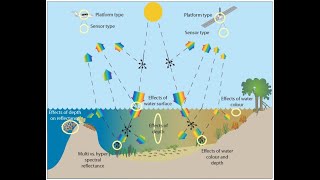
Integration with GIS Tools
Chapter 2 of 2
🔒 Unlock Audio Chapter
Sign up and enroll to access the full audio experience
Chapter Content
• Integration with GIS tools for:
– Spatial mapping of rainfall
– Catchment-wide planning
– Flood and drought risk assessment
Detailed Explanation
GIS, or Geographic Information Systems, is a technology used to visualize, analyze, and interpret data related to the positions on the Earth's surface. Integrating rainfall data from satellites into GIS tools allows for detailed spatial mapping of rainfall patterns. This integration helps in planning water management strategies across entire catchments. Additionally, it can be used for assessing risks related to floods and droughts by identifying areas vulnerable to these events.
Examples & Analogies
Think of a city planner using a map to track where the rain falls most heavily. By overlaying rainfall data onto a city map, they can identify areas that might flood during heavy rains or those that might suffer from droughts. Just like using a map to plan a road trip, GIS helps planners navigate the complexities of rainfall distribution and its impacts.
Key Concepts
-
Remote Sensing: Collecting data from satellites to measure rainfall.
-
GIS: A tool for spatial mapping and analysis of rainfall data.
-
INSAT: Indian satellites for meteorological purposes.
-
Flood and Drought Assessment: Assessing risks based on rainfall data.
Examples & Applications
Using TRMM data, analysts can identify areas receiving below-average rainfall, alerting local authorities to potential drought conditions.
INSAT provides real-time rainfall data that aids in the timely evacuation of coastal areas at risk of flooding.
Memory Aids
Interactive tools to help you remember key concepts
Rhymes
To seek the rain, satellites fly, collecting data from the sky.
Stories
Imagine a satellite named Rainy that could see the Earth's weather. It would pinpoint areas that needed help, just like a superhero for rainfall analysis.
Memory Tools
Remember 'RS-GIS-FD' for Remote Sensing, GIS, and Flood/Drought risk – they go hand in hand.
Acronyms
Use 'SGI'–Satellite, GIS, Integration, to remember the main components in rainfall analysis.
Flash Cards
Glossary
- Remote Sensing
The process of obtaining information about an object or area from a distance, typically using satellite or aerial technologies.
- GIS (Geographic Information System)
A system designed to capture, store, manipulate, analyze, manage, and present spatial or geographic data.
- INSAT
Indian National Satellite System, which provides various services including weather monitoring.
- TRMM (Tropical Rainfall Measuring Mission)
A satellite that was designed to monitor and study rainfall in tropical regions.
- Flood Risk Assessment
The evaluation of potential flood hazards in order to implement appropriate mitigation strategies.
- Drought Assessment
The process of evaluating the likelihood and impact of drought conditions in a specific region.
Reference links
Supplementary resources to enhance your learning experience.