
Distribution of Rainfall
Enroll to start learning
You’ve not yet enrolled in this course. Please enroll for free to listen to audio lessons, classroom podcasts and take practice test.
Interactive Audio Lesson
Listen to a student-teacher conversation explaining the topic in a relatable way.
Rainfall Extremes in India
🔒 Unlock Audio Lesson
Sign up and enroll to listen to this audio lesson

Today we'll explore the rainfall distribution in India. Can anyone tell me where the highest rainfall occurs?

Is it Mawsynram in Meghalaya?
Exactly! Mawsynram is known for its heavy rainfall, making it the wettest place in India. Can you guess how much rainfall it receives?

I believe it's around 467 inches a year!
Great! That’s correct! Now, what about the driest region in India?

Isn’t it Jaisalmer in Rajasthan?
Yes, Jaisalmer has the lowest rainfall, receiving barely 8 inches annually. What factors do you think contribute to this stark difference in rainfall?

The location and geography play a big role, right?
Absolutely! The geographical factors significantly influence the climate and rainfall distribution across these regions.
To summarize, India’s highest and lowest rainfall points are Mawsynram and Jaisalmer, respectively, showing the vast diversity of our climate.
Influence of Geographical Features
🔒 Unlock Audio Lesson
Sign up and enroll to listen to this audio lesson

Now, let’s dive into how geographical features influence rainfall. Can anyone name a feature that allows heavy rainfall?
The Western Ghats trap monsoon winds, don’t they?
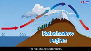
Exactly! The Western Ghats elevate the moisture-laden winds, causing orographic rainfall. How does that contrast with the Deccan Plateau?
The Deccan Plateau is inland and doesn’t get much monsoonal moisture.
Correct! The interior regions like the Deccan Plateau experience low rainfall because they are far from the ocean and are shielded by the mountains. So, what’s your takeaway from this?
Geographical features can make a huge difference in how much rain a region receives!
Well said! Remember, features like mountains, valleys, and distance from the coast all play vital roles in shaping climate and rainfall.
Impact of Rainfall Distribution
🔒 Unlock Audio Lesson
Sign up and enroll to listen to this audio lesson
Let’s connect the rainfall distribution to its impact on society. How does it affect agriculture?
Regions with heavy rainfall can support more crops, right?
Absolutely! Areas like the Western Ghats thrive agriculturally due to ample rainfall, while places like Jaisalmer struggle. How does this affect people’s lives?
People in arid regions may face challenges with farming and water supply.
Exactly! This can lead to economic issues and even migration. How can we mitigate problems in low rainfall areas?
Maybe using irrigation or rainwater harvesting?
Great solutions! Understanding rainfall distribution is crucial for developing strategies to tackle drought and resource management.
Introduction & Overview
Read summaries of the section's main ideas at different levels of detail.
Quick Overview
Standard
This section details the areas in India that receive the most and least rainfall. It mentions Mawsynram as the wettest point and Jaisalmer as the driest, explaining how geographical features like the Western Ghats and the Deccan Plateau influence these patterns.
Detailed
Distribution of Rainfall
In this section, we focus on the distribution of rainfall across India, a critical aspect of the country’s climate. Rainfall varies significantly across different regions, with some areas experiencing heavy precipitation while others remain arid.
Key Highlights:
- Wettest Region: The highest recorded rainfall in India is at Mawsynram in Meghalaya, characterized by its lush landscapes.
- Driest Region: Conversely, Jaisalmer in Rajasthan experiences the lowest rainfall, illustrating how arid conditions can exist even within the diverse climate of India.
- Geographical Impact: Regions such as the Western Ghats and Northeastern states, influenced by monsoon winds, receive significant rainfall.
- Low Rainfall Areas: The interior Deccan Plateau and western Rajasthan are known for their low rainfall, impacted by local climatic conditions that limit moisture availability.
Understanding rainfall distribution is essential, as it affects agriculture, water supply, and overall ecological health.
Youtube Videos


Audio Book
Dive deep into the subject with an immersive audiobook experience.
Highest Rainfall Location
Chapter 1 of 4
🔒 Unlock Audio Chapter
Sign up and enroll to access the full audio experience
Chapter Content
● Highest rainfall: Mawsynram (Meghalaya)
Detailed Explanation
Mawsynram, a village located in Meghalaya, India, holds the record for the highest average annual rainfall in the world. This remarkable amount of rainfall is primarily due to its geographical position and the influence of the monsoon winds that bring moisture from the Indian Ocean. The orographic effect, where moist air rises over the hills, ensures that Mawsynram receives an enormous amount of rain every year, contributing to its lush green landscape.
Examples & Analogies
Think of Mawsynram as a sponge that soaks up water. Just like how a sponge becomes heavier when submerged in water, Mawsynram becomes ‘heavier’ with rain due to its position in the path of moisture-laden winds coming from the ocean.
Lowest Rainfall Location
Chapter 2 of 4
🔒 Unlock Audio Chapter
Sign up and enroll to access the full audio experience
Chapter Content
● Lowest rainfall: Jaisalmer (Rajasthan)
Detailed Explanation
In contrast to Mawsynram, Jaisalmer in Rajasthan experiences the lowest average annual rainfall in India. Located in the Thar Desert, Jaisalmer receives very little precipitation due to its arid climate. The desert landscape, characterized by sandy soil and limited vegetation, results in high temperatures and dry conditions for most of the year. The lack of significant geographical features to capture moist winds leads to minimal rainfall.
Examples & Analogies
Imagine a dry sponge left out in the sun; it doesn’t collect any water because it’s not in a damp area. Similarly, Jaisalmer doesn’t get much rain because it’s located in a desert, far away from the moisture-laden winds that bring rain.
Regions with Heavy Rainfall
Chapter 3 of 4
🔒 Unlock Audio Chapter
Sign up and enroll to access the full audio experience
Chapter Content
● Western Ghats and Northeast receive heavy rainfall.
Detailed Explanation
Both the Western Ghats and the Northeastern region of India are known for receiving significant rainfall. The Western Ghats, running parallel to the western coast, intercept the southwest monsoon winds, causing heavy rainfall on the windward side. Similarly, the Northeastern states, located in the path of the monsoon, also absorb a substantial amount of rainfall. The combination of geography and monsoonal winds leads to these regions supporting rich biodiversity and lush vegetation due to the high levels of moisture.
Examples & Analogies
Picture a giant umbrella that catches raindrops. The Western Ghats act like this umbrella by blocking the monsoon clouds and forcing them to release their rain, resulting in a verdant landscape filled with rich flora and fauna.
Regions with Low Rainfall
Chapter 4 of 4
🔒 Unlock Audio Chapter
Sign up and enroll to access the full audio experience
Chapter Content
● Interior Deccan Plateau and western Rajasthan get low rainfall.
Detailed Explanation
The Interior Deccan Plateau and Western Rajasthan are regions that experience low annual rainfall. The Deccan Plateau, being further away from the moisture sources, receives less rainfall compared to coastal areas. Similarly, Western Rajasthan, characterized by its arid desert landscape, has limited rainfall due to its geographical location and climate conditions. The combination of distance from the sea and vast plateaus results in dry and less fertile lands.
Examples & Analogies
Think of a water fountain that only sprays water a few feet—it won’t reach the areas far away. Similarly, the rainfall from the oceans primarily nourishes the coastal regions while the inland areas like the Deccan Plateau and Western Rajasthan receive only a fraction of that water, leading to dry conditions.
Key Concepts
-
Mawsynram: The wettest place in India, known for extreme rainfall.
-
Jaisalmer: The driest location, demonstrating significant climatic contrast.
-
Geographical influences: Mountains like the Western Ghats affect how rainfall is distributed across regions.
-
Orographic rain: A phenomenon that occurs when moist air is lifted over mountains, leading to precipitation.
Examples & Applications
Mawsynram in Meghalaya illustrates regions receiving over 467 inches of rain annually, while Jaisalmer in Rajasthan showcases areas with only about 8 inches of rain.
The Western Ghats capture monsoon winds, resulting in heavy rainfall in the coastal regions, while the interior Deccan Plateau remains dry.
Memory Aids
Interactive tools to help you remember key concepts
Rhymes
Mawsynram, so wet and grand, swamped by monsoons, a lush land; Jaisalmer, so dry and bright, with just a drizzle, a sandy sight.
Stories
Once upon a time, in the lush green hills of Mawsynram, the clouds were friends with the earth, pouring rain, while in the vast desert of Jaisalmer, the sun ruled the days, refusing to share water.
Memory Tools
Remember 'M' for Mawsynram and 'J' for Jaisalmer - 'M' is Maximum (rainfall) and 'J' is Just a little (rain).
Acronyms
Use the acronym WED
Wettest (Mawsynram)
Extremely dry (Jaisalmer)
Distribution via Geography.
Flash Cards
Glossary
- Rainfall
The precipitation that falls from the atmosphere to the earth, essential for replenishing water sources.
- Geographical Features
Natural landforms such as mountains, valleys, and plains that influence the climate and weather patterns of a region.
- Mawsynram
A village in Meghalaya, known as the wettest place on Earth, receiving the highest average annual rainfall.
- Jaisalmer
A city in Rajasthan noted for having the lowest average annual rainfall in India.
- Orographic Rainfall
Rainfall that occurs when moist air is lifted over a mountain range, cooling and condensing to form precipitation.
Reference links
Supplementary resources to enhance your learning experience.