
Earthquake Zoning and Seismic Hazard Maps
Enroll to start learning
You’ve not yet enrolled in this course. Please enroll for free to listen to audio lessons, classroom podcasts and take practice test.
Interactive Audio Lesson
Listen to a student-teacher conversation explaining the topic in a relatable way.
Introduction to Seismic Zoning
🔒 Unlock Audio Lesson
Sign up and enroll to listen to this audio lesson

Today, we're discussing seismic zoning. Can anyone tell me what seismic zoning is?

Is it about dividing areas based on how risky they are for earthquakes?
Exactly! Seismic zoning divides regions into several hazard levels. For instance, in India, we have Zone II being the least vulnerable and Zone V as the highest. Remember the phrase 'Zocas are zones', that could help you recall this grading system.

What determines these zones?
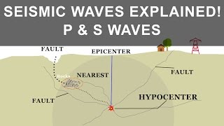
Great question! We consider past seismicity, tectonic features, fault zones, and soil conditions.
Parameters Considered in Zoning
🔒 Unlock Audio Lesson
Sign up and enroll to listen to this audio lesson

Now, let's explore what parameters we consider for determining the seismic zones. Can anyone name one?

Uh, I think... past seismicity?
Correct! Past seismicity is critical because it helps predict future risks. Another factor involves soil conditions. Can someone elaborate on that?

I read that certain soil types can amplify seismic waves, right?
Exactly! Soft soils can lead to stronger shaking compared to hard rock. This is significant when designing buildings.
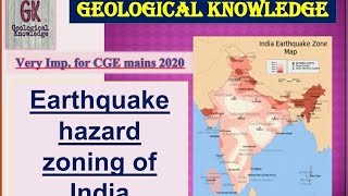
The Indian Seismic Zoning Map
🔒 Unlock Audio Lesson
Sign up and enroll to listen to this audio lesson
Now let's talk about the Indian Seismic Zoning Map. Why is it essential for engineers?
It helps them understand how much the buildings should be able to withstand during earthquakes.
Right! It provides design acceleration values for each zone. It's governed by the standard IS:1893, which ensures structures are built adequately to handle seismic forces.
Is the map updated regularly? How often?
Yes! It is updated periodically based on new seismic data. Keeping it current ensures our engineering practices adapt to the latest information.
Introduction & Overview
Read summaries of the section's main ideas at different levels of detail.
Quick Overview
Standard
Earthquake zoning classifies regions based on seismic hazard levels, with specific parameters considered for assessment. The Indian Seismic Zoning Map provides valuable design acceleration values for engineers to create earthquake-resistant structures.
Detailed
Earthquake Zoning and Seismic Hazard Maps
Earthquake Zoning and Seismic Hazard Maps are crucial for understanding and mitigating the risks posed by earthquakes. In this section, we begin with Seismic Zoning, which divides regions into different categories (Zone II, III, IV, and V in India), indicating their respective seismic hazard levels, with Zone V representing the highest risk. Key parameters influencing these zones include past seismic activity, tectonic features, fault zones, and soil conditions.
Specifically, India’s seismic zoning map, governed by standard IS:1893, delineates various zones and associated design acceleration values (Z) that engineers must incorporate into their designs to ensure safety against seismic activities. Furthermore, this map is periodically updated based on new seismic data, ensuring that it remains relevant and useful for risk mitigation efforts.
Youtube Videos


Audio Book
Dive deep into the subject with an immersive audiobook experience.
Seismic Zoning
Chapter 1 of 3
🔒 Unlock Audio Chapter
Sign up and enroll to access the full audio experience
Chapter Content
• Divides regions based on seismic hazard levels.
• In India, zones are classified as Zone II, III, IV, and V (Zone V being most severe).
Detailed Explanation
Seismic zoning is a process that categorizes geographical areas according to the likelihood of experiencing earthquakes and the severity of potential shaking. In India, different zones are established to help with urban planning and construction standards. Zone V represents areas with the highest seismic risk and requires structures to be built to withstand strong earthquakes, whereas Zone II represents areas with the lowest risk.
Examples & Analogies
Think of seismic zoning like a weather forecast that tells you how much to prepare for different weather conditions. Just as you might wear a raincoat in a heavy rain zone and sunglasses in a sunny zone, buildings need different designs in high seismic zones compared to areas with less earthquake risk.
Parameters Considered in Seismic Zoning
Chapter 2 of 3
🔒 Unlock Audio Chapter
Sign up and enroll to access the full audio experience
Chapter Content
• Past seismicity.
• Tectonic features.
• Fault zones.
• Soil conditions.
Detailed Explanation
Several factors are taken into account when creating seismic zones. Past seismicity includes historical records of earthquakes, helping scientists understand which areas are prone to future quakes. Tectonic features refer to the physical characteristics of the Earth’s crust in a region. Fault zones indicate where earthquakes can occur due to the movement of tectonic plates. Finally, soil conditions affect how ground shaking occurs; softer soils can amplify shaking, increasing the risk of damage.
Examples & Analogies
Imagine you are choosing a place for a picnic. You would consider the weather (past conditions), nearby hills (tectonic features), any fences (fault zones), and whether the ground is firm or muddy (soil conditions). All these parameters help you decide the safest and most enjoyable spot for your picnic.
Indian Seismic Zoning Map (IS:1893)
Chapter 3 of 3
🔒 Unlock Audio Chapter
Sign up and enroll to access the full audio experience
Chapter Content
• Provides design acceleration values (Z) for each zone.
• Updated periodically based on new data.
Detailed Explanation
The Indian Seismic Zoning Map, established under the code IS:1893, specifies design acceleration values corresponding to each seismic zone. These values indicate how much shaking structures can expect during an earthquake. Additionally, this map gets updated with new data to reflect changes in our understanding of seismic risks, ensuring that building codes remain relevant and effective.
Examples & Analogies
It’s similar to updating a smartphone app. Just as the app developers update the software to address bugs or add features, seismologists update the seismic zoning map to reflect new information on earthquakes, making sure the guidelines for building structures are accurate and useful.
Key Concepts
-
Seismic Zoning: Classification of regions based on risk levels to assign appropriate engineering responses.
-
Parameters for Zoning: Factors like past seismicity, soil types, and fault zones that influence regional assessments.
-
Design Acceleration Values: Metrics for engineers based on seismic zone classification to ensure safety in construction.
-
Indian Seismic Zoning Map: A critical tool for understanding earthquake risks and guiding safe structural design.
Examples & Applications
In India, regions slotted into Zone V must adhere to stricter building codes due to higher seismic risks compared to Zone II regions.
Engineers designing high-rise buildings in city centers often refer to the seismic hazard map to create structures that can endure substantial ground shaking.
Memory Aids
Interactive tools to help you remember key concepts
Rhymes
Zoning in phases, from low to high, II's not a worry, but V's quite the sigh.
Stories
Imagine a builder in India. For his new skyscraper in Zone II, he only needs moderate defenses, but for another in Zone V, he has to ensure it's fortified against any quake!
Memory Tools
Remember 'ZPV' for Zones: Z for Zones, P for Parameters, V for Values.
Acronyms
ZONES - Zonal Organization Noting Earthquake Safety.
Flash Cards
Glossary
- Seismic Zoning
The classification of regions based on their seismic hazard levels to guide engineering and planning efforts.
- Seismic Hazard Map
A map that illustrates potential earthquake impacts and hazards in a specific region, based on past seismic activity and geological features.
- Design Acceleration Values (Z)
Values provided in seismic maps that inform engineers about the expected ground motion for structures in specific seismic zones.
- Indian Seismic Zoning Map (IS:1893)
A standard that delineates seismic zones in India and provides guidelines for designing earthquake-resistant structures.
Reference links
Supplementary resources to enhance your learning experience.