
Epicentre and Earthquake Engineering Applications
Enroll to start learning
You’ve not yet enrolled in this course. Please enroll for free to listen to audio lessons, classroom podcasts and take practice test.
Interactive Audio Lesson
Listen to a student-teacher conversation explaining the topic in a relatable way.
Hazard Mapping
🔒 Unlock Audio Lesson
Sign up and enroll to listen to this audio lesson

Today, we’ll explore how epicentre data helps in seismic hazard mapping. Can anyone tell me what hazard mapping is?

Isn't it about identifying areas that are at risk of earthquakes?
Exactly! Hazard mapping uses epicentre locations to determine which areas are more vulnerable to seismic events. This is crucial for planning and building regulations. Remember the acronym 'MAP' - 'Mitigate, Assess, Plan.' It helps us remember why we create hazard maps.

How does that relate to building codes?
Great question! Building codes specify how structures should be designed based on the seismic risk represented in these maps. So, understanding the epicentre is foundational.

What happens if a map is outdated?
If a seismic hazard map is outdated, it might not accurately reflect current risks, leading to inadequate safety measures. Thus, regular updates using recent epicentre data are essential.
To summarize, hazard mapping guides mitigation strategies. It uses data about epicentres to assess risk and inform planning and construction.
Emergency Response
🔒 Unlock Audio Lesson
Sign up and enroll to listen to this audio lesson

Now let’s discuss how identifying the epicentre helps in emergency responses. Why do you think it's important?
It helps rescue teams know where to go first!
Exactly! Quick identification of the epicentre allows for efficient resource distribution. Remember the term 'ER' for Emergency Response. This points to the critical nature of timely information.

What about early warning systems?
Good point! Epicentre data feeds into early warning systems, which provide alerts seconds before shaking starts. It’s vital for minimizing damage and saving lives.
How do responders prepare with this information?
Preparedness plans are informed by the location of likely epicentres, allowing responders to practice and strategize effectively.
In summary, knowing the epicentre significantly enhances emergency response efforts and is key to effective risk mitigation.
Retrofitting and Design Codes
🔒 Unlock Audio Lesson
Sign up and enroll to listen to this audio lesson
Let’s move on to how epicentre data influences design codes. Why do you think engineers need this information?
To make buildings strong enough to handle earthquakes?
Exactly! Engineers must know where potential epicentres are to create earthquake-resistant structures. Use the acronym 'SHEAR' - 'Seismic, Hazard, Engineering, Assessment, Resilience.' This captures the key aspects of earthquake-resistant design.
How does that affect critical infrastructure?
Critical infrastructure, like bridges and nuclear plants, requires specific designs to endure seismic forces, which are heavily influenced by the expected epicentre locations.
What about retrofitting?
Great thought! Retrofitting older buildings involves updating them based on current epicentre data to improve their resilience.
To summarize, understanding the epicentre is vital in developing robust structural design codes and retrofitting plans.
Introduction & Overview
Read summaries of the section's main ideas at different levels of detail.
Quick Overview
Standard
The section discusses the applications of epicentre data in earthquake engineering, focusing on three key areas: hazard mapping for seismic zoning, emergency response strategies, and the development of design codes for resilient infrastructure. Understanding the epicentre is crucial for effective disaster risk mitigation.
Detailed
Epicentre and Earthquake Engineering Applications
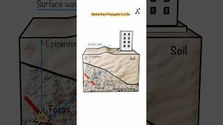
In the realm of earthquake engineering, understanding the epicentre—the point directly above the focus (hypocentre)—is critical for several applications. This section highlights three main areas where epicentre data plays a pivotal role:
1. Hazard Mapping
Epicentral data are essential for creating seismic hazard maps, which are used for zoning areas based on their risk of seismic activity. This information guides land-use planning and informs building code regulations, ensuring that new constructions are designed with adequate safety measures to withstand potential earthquakes.
2. Emergency Response and Risk Mitigation
Rapidly identifying the epicentre of an earthquake is vital for emergency response teams. Knowing the location allows for efficient allocation of rescue operations and medical resources in the aftermath of seismic events. Furthermore, epicentre data contribute to the development of early warning systems, providing alerts before seismic waves cause significant ground shaking.
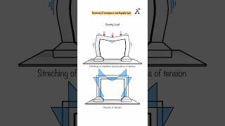
3. Retrofitting and Design Codes
The location of the epicentre and associated seismic data influence the structural design of buildings and infrastructure. Engineers rely on this information to inform design codes that enhance earthquake resilience. This is particularly crucial for critical infrastructure, such as dams, nuclear plants, and bridges, which must be retrofitted or constructed to endure seismic forces.
Overall, understanding the epicentre is integral for effective mitigation strategies and constructing resilient urban environments.
Youtube Videos


Audio Book
Dive deep into the subject with an immersive audiobook experience.
Hazard Mapping
Chapter 1 of 3
🔒 Unlock Audio Chapter
Sign up and enroll to access the full audio experience
Chapter Content
• Epicentral data contributes to seismic hazard zoning.
• Helps in land-use planning and building code regulation.
Detailed Explanation
Hazard mapping is the process of identifying and categorizing areas based on the level of risk they face from earthquakes. By using data about the epicentres of past earthquakes, engineers and urban planners can create maps that show which regions are most vulnerable. This information is key for making informed decisions about where to build homes, schools, and other structures. Additionally, building codes can be updated to ensure that new constructions are designed to withstand expected seismic activity.
Examples & Analogies
Imagine you are a city planner and you want to build a new school. If you know from epicentre data that the area has a high risk of earthquakes, you would choose materials and designs that can withstand shaking. It's like choosing to wear a helmet when riding a bike in a busy city — you're taking precautions based on the known risks in the environment.
Emergency Response and Risk Mitigation
Chapter 2 of 3
🔒 Unlock Audio Chapter
Sign up and enroll to access the full audio experience
Chapter Content
• Rapid identification of epicentre enables efficient deployment of rescue and medical resources.
• Used in early warning systems.
Detailed Explanation
When an earthquake occurs, knowing the location of the epicentre quickly can save lives. Emergency responders use this information to send help to the right places immediately. For instance, if the epicentre is located in a populated city, resources like ambulances, rescue teams, and medical supplies can be dispatched faster to address the needs of those affected. Furthermore, early warning systems can detect seismic waves and alert people seconds before the stronger waves hit, giving them a chance to drop to the ground or take cover.
Examples & Analogies
Think of it like being in a stadium when a storm is approaching. If a weather app sends an alert to everyone, telling them to take shelter just before the heavy rain hits, people can move to safety before getting wet. Similarly, earthquake early warning systems provide crucial seconds of warning to people in earthquake-prone areas, allowing them time to protect themselves.
Retrofitting and Design Codes
Chapter 3 of 3
🔒 Unlock Audio Chapter
Sign up and enroll to access the full audio experience
Chapter Content
• Epicentre location data informs structural design for earthquake resilience.
• Critical for critical infrastructure like dams, nuclear plants, and bridges.
Detailed Explanation
Retrofitting refers to enhancing existing structures to make them more resilient to earthquakes. By understanding where earthquakes commonly occur and how severely they may affect certain areas, engineers can develop design codes that require buildings and infrastructure to be built to withstand these forces. This is especially important for critical facilities, like dams that hold back water and nuclear plants where safety is paramount. Epicentre data allows engineers to create safer designs tailored to specific risks in their locations.
Examples & Analogies
Imagine an Olympic bridge that was designed before we fully understood how earthquakes could affect it. If that bridge is retrofitted after learning about possible epicentres nearby, it would be like giving the bridge a 'safety upgrade' — just like adding a seatbelt to an old car to make it safer in case of an accident. This ensures that crucial structures can perform their functions even in the aftermath of a quake.
Key Concepts
-
Seismic Hazard Mapping: The process used to identify areas at risk of earthquakes.
-
Emergency Response: Strategies and actions taken following an earthquake to aid recovery.
-
Retrofitting: Strengthening existing structures to enhance their ability to withstand seismic forces.
Examples & Applications
Using earthquake epicentre data, city planners can determine where to place new hospitals to ensure rapid access during emergencies.
Following the 2011 earthquake in Japan, retrofitting measures were enforced based on revised epicentre locations to improve building safety.
Memory Aids
Interactive tools to help you remember key concepts
Rhymes
Find the epicentre where quakes are centered; for safety, mapping is the way to be mentored.
Stories
Imagine a village facing endless earthquakes. They marked their epicentres, allowing them to build strong homes and respond swiftly whenever the earth shook a bit too hard.
Memory Tools
Remember 'EAR' for Epicentre, Assessment, Response. It encapsulates the core concepts we need to remember about earthquakes.
Acronyms
MAP - Mitigate, Assess, Plan, helps us remember the purpose of hazard mapping.
Flash Cards
Glossary
- Epicentre
The point on the Earth's surface directly above the hypocentre where an earthquake originated.
- Hypocentre
The location beneath the Earth's surface where fault rupture and seismic energy release actually begin.
- Seismic hazard mapping
A process of determining zones of varying levels of earthquake risk.
- Emergency response
Actions taken to address the immediate aftermath of an earthquake, aimed at saving lives and providing assistance.
- Retrofitting
The process of strengthening existing buildings and infrastructure to improve their resilience to earthquakes.
Reference links
Supplementary resources to enhance your learning experience.