
Factors Influencing Epicentre Accuracy
Enroll to start learning
You’ve not yet enrolled in this course. Please enroll for free to listen to audio lessons, classroom podcasts and take practice test.
Interactive Audio Lesson
Listen to a student-teacher conversation explaining the topic in a relatable way.
Density and Distribution of Seismic Stations
🔒 Unlock Audio Lesson
Sign up and enroll to listen to this audio lesson

Today, we're going to explore how the density and distribution of seismic stations can impact the accuracy of epicentre location. Can anyone tell me why having more seismic stations is beneficial?

I think having more stations means you can collect more data and have multiple points to calculate the epicentre.
Exactly! Dense networks improve the precision of epicentral coordinates because we can triangulate the position more effectively. Remember, more data leads to more precise results. Can anyone give an example of what happens with sparse networks?

With fewer stations, the accuracy goes down, so you might end up with a larger error in the epicentre's location.
Great point! Larger location errors due to sparse data can lead to significant issues in understanding the earthquake's impact. Now, let’s summarize: What are the key takeaways about seismic station density?

More stations mean better accuracy, while fewer stations lead to larger errors!
Perfect! Let’s move on.
Earthquake Depth and Magnitude
🔒 Unlock Audio Lesson
Sign up and enroll to listen to this audio lesson

Next, let's talk about earthquake depth and magnitude. How does depth affect our ability to determine the epicentre?

I think deeper earthquakes are harder to pinpoint because the seismic waves take longer to reach the surface.
Correct! The complexity of wave paths in deeper earthquakes contributes to the difficulty in accurately locating their epicentres. On the other hand, how might an earthquake's magnitude affect this?
Larger earthquakes produce clearer signals, making them easier to triangulate.
Exactly! Larger magnitudes help in identifying the epicentre more precisely. Can anyone summarize the impacts of depth and magnitude on epicentre accuracy?
Deeper earthquakes are harder to locate, while larger ones are clearer and easier to triangulate.
Excellent summary! Now, let’s move to the next topic.
Crustal Heterogeneity
🔒 Unlock Audio Lesson
Sign up and enroll to listen to this audio lesson
The last topic we'll cover today is crustal heterogeneity. What do we mean by this term?
It refers to the different densities and layers of rock found in the Earth’s crust.
Exactly! And how do these variations impact the accuracy of epicentre determination?
They can distort the wave paths, making it harder to get an accurate location.
That's right! Distortions require corrections and calibrations in seismic models. Can you think of a way to remember this process?
Maybe by thinking of rocks as puzzle pieces that fit together differently, affecting how waves travel through them?
Great analogy! Remembering that crustal integrity affects wave paths helps clarify the importance of geological context in seismic studies. Let’s summarize what we learned today.
Density and distribution of seismic stations improve accuracy, deeper earthquakes complicate location, and crustal variations distort wave paths!
Excellent summary, everyone! Keep these points in mind as you study further.
Introduction & Overview
Read summaries of the section's main ideas at different levels of detail.
Quick Overview
Standard
Factors affecting the accuracy of epicentre determination include the density and distribution of seismic stations, the depth and magnitude of earthquakes, and the heterogeneity of the Earth's crust. Each of these factors can either enhance or impede the precision in locating an earthquake's epicentre.
Detailed
In the study of earthquakes, accurately determining the epicentre is crucial for assessing potential impacts on affected areas. Several factors influence the accuracy of epicentre localization:
- Density and Distribution of Seismic Stations: A dense network of seismic stations leads to higher accuracy in epicentral coordinates, while sparse networks tend to produce larger errors in location.
- Earthquake Depth and Magnitude: The complexity of wave paths makes it more challenging to locate deep-focus earthquakes accurately. In contrast, larger earthquakes typically produce clearer signals, facilitating triangulation.
- Crustal Heterogeneity: Variations in rock density and geological characteristics can distort the paths of seismic waves, necessitating corrections to seismic models.
Understanding these factors is fundamental for engineers, urban planners, and emergency responders to mitigate earthquake impacts effectively.
Youtube Videos


Audio Book
Dive deep into the subject with an immersive audiobook experience.
Density and Distribution of Seismic Stations
Chapter 1 of 3
🔒 Unlock Audio Chapter
Sign up and enroll to access the full audio experience
Chapter Content
• Sparse networks lead to larger location errors.
• Denser networks improve the accuracy of epicentral coordinates.
Detailed Explanation
The accuracy of determining an earthquake's epicentre is significantly affected by how many seismic stations are monitoring an area. Sparse networks mean there are fewer stations to collect data, which can lead to larger errors in locating the epicentre. In contrast, a dense network with more stations can provide more precise coordinates, leading to a better understanding of where the earthquake originated.
Examples & Analogies
Think of it like trying to find the center of a large pie. If you only have a few slices (sparse stations), it’s hard to tell exactly where the center is. However, if you have more slices (denser stations) across the pie, you can pinpoint the center much more accurately.
Earthquake Depth and Magnitude
Chapter 2 of 3
🔒 Unlock Audio Chapter
Sign up and enroll to access the full audio experience
Chapter Content
• Deep-focus earthquakes make epicentre localization more difficult due to wave path complexity.
• Larger events produce clearer signals and are easier to triangulate.
Detailed Explanation
Earthquake depth plays a critical role in how easily we can find the epicentre. For deep-focus earthquakes, the pathways that seismic waves travel are often complex, which can create difficulties in accurately locating the epicentre. However, larger earthquakes tend to produce stronger signals that are easier for seismologists to detect and triangulate, improving the accuracy of epicentre determination.
Examples & Analogies
Imagine talking to a friend over a long distance phone call. If they’re speaking in a loud room (large earthquake), their voice is easier to hear and locate. But if they’re whispering from a basement (deep-focus earthquake), their voice becomes muffled and harder to pinpoint.
Crustal Heterogeneity
Chapter 3 of 3
🔒 Unlock Audio Chapter
Sign up and enroll to access the full audio experience
Chapter Content
• Variations in rock density, fault systems, and geological layers distort wave paths.
• Requires corrections and calibration of seismic models.
Detailed Explanation
The Earth’s crust is not uniform; it consists of various materials and geological structures. These variations, known as crustal heterogeneity, can distort the paths that seismic waves take as they travel through the Earth. Because of this distortion, seismologists need to make adjustments and calibrate their models to accurately interpret the data and locate the epicentre effectively.
Examples & Analogies
Think of it like sending a light beam through different materials. If you pass light through water, it bends differently than if it goes through air or glass. Similarly, seismic waves change direction when they encounter different types of rock, complicating the location of the earthquake's epicentre.
Key Concepts
-
Epicentre Accuracy: Influenced by seismic station density and distribution.
-
Earthquake Depth: Affects the complexity of wave paths and localization.
-
Magnitude Effects: Higher magnitudes result in clearer signals for triangulation.
-
Crustal Heterogeneity: Geological variations distort seismic wave paths.
Examples & Applications
A dense network of seismic stations leads to more precise epicentre localization, while a sparse network results in greater errors in the calculated location.
Deep-focus earthquakes, like those occurring at depths greater than 300 km, pose challenges for accurate epicentre determination due to complex wave propagation.
Memory Aids
Interactive tools to help you remember key concepts
Rhymes
More stations mean good relations, less error in the epicentre's locations.
Stories
Imagine a treasure map where the 'X' marks the spot. The more markers you have, the more accurately you find the 'X', just like epicentral coordinates depend on multiple seismic stations.
Memory Tools
Remember 'SML' for epicentre factors: Stations, Magnitude, and Layer differences.
Acronyms
DRE for factors
Density of stations
Rock variation
Earthquake depth.
Flash Cards
Glossary
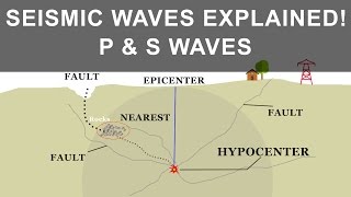
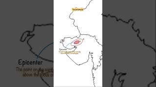
- Epicentre
The point on the Earth's surface directly above the focus of an earthquake.
- Hypocentre
The point within the Earth where an earthquake originates.
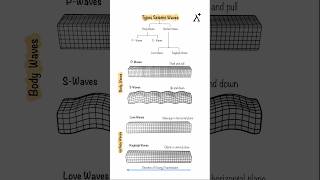
- Seismic Waves
Waves of energy that travel through the Earth, generated by an earthquake.
- Triangulation
A method to determine the location of an epicentre by using the intersection of circles from seismic data.
- Crustal Heterogeneity
Variations in the Earth's crust in terms of material composition and density that affect seismic wave propagation.
Reference links
Supplementary resources to enhance your learning experience.