
Errors and Uncertainty in Epicentre Location
Enroll to start learning
You’ve not yet enrolled in this course. Please enroll for free to listen to audio lessons, classroom podcasts and take practice test.
Interactive Audio Lesson
Listen to a student-teacher conversation explaining the topic in a relatable way.
Instrumental and Human Errors
🔒 Unlock Audio Lesson
Sign up and enroll to listen to this audio lesson

Let's start by exploring how instrumental and human errors can affect our ability to locate an earthquake's epicentre. Can anyone think of a reason why these errors might occur?

Maybe sometimes the instruments aren't calibrated correctly?
Exactly! Instrument calibration issues can lead to incorrect arrival time readings. When seismic waves travel, if our instruments aren't set up correctly, we won't get an accurate reading.

What about communication between different stations? Could that be a problem?
Great point! Time synchronization errors can occur among different seismic stations, which can lead to confusion in determining the exact epicentre. Remember, accurate timing is critical!
To summarize, instrumental errors can stem from calibration problems and miscommunication. These errors result in poor data integrity for epicentral calculations.
Geological and Computational Limitations
🔒 Unlock Audio Lesson
Sign up and enroll to listen to this audio lesson

Now, let's discuss geological and computational limitations. Why do you think geological structures matter in epicentre determination?

Because the different types of rock can change how fast seismic waves travel, right?
Exactly! Variations in crustal structures lead to different wave speeds and paths. This complexity is often simplified in uniform Earth models, which don't portray the reality of Earth's varying geology.

So, that means if the model is inaccurate, the epicentre location will be too?
Exactly right! The inaccuracies in the model can lead to significant location errors. Always keep in mind that geological knowledge is essential in helping refine our estimations.
In summary, geological variations complicate the epicentre location process, and computational models need to reflect these complexities for more accurate results.
Error Ellipses
🔒 Unlock Audio Lesson
Sign up and enroll to listen to this audio lesson
Let’s explore how epicentral uncertainties are represented. Can anyone tell me what an error ellipse is?
Isn't it a shape that shows how uncertain we are about the epicentre's exact location?
Yes! An error ellipse indicates the region where the epicentre could possibly be located based on the data we have. The size and shape of this ellipse can tell us about the accuracy of our measurements.
So, if we have a larger ellipse, that means we were less accurate?
Correct! A larger ellipse suggests greater uncertainty, while a smaller ellipse indicates higher precision in our calculations. The geometry of the station network also influences this—more stations typically lead to smaller ellipses.
In summary, error ellipses are crucial for visualizing the uncertainty in epicentre location, giving us an idea of confidence in our data.
Introduction & Overview
Read summaries of the section's main ideas at different levels of detail.
Quick Overview
Standard
The section highlights how different factors, such as human error in instrument calibration, geological complexities, and station distribution, can lead to inaccuracies in epicentre estimation. It also explains how the epicentral uncertainty is represented and its implications for earthquake data interpretation.
Detailed
Errors and Uncertainty in Epicentre Location
This section delves into the critical aspects of errors and uncertainties encountered during the determination of an earthquake's epicentre. Accurate epicentre location is essential for effective earthquake assessment, yet various factors can compromise this accuracy.
24.13.1 Instrumental and Human Errors
- Instrument calibration issues and errors in arrival time readings can introduce inaccuracies in epicentre location. Moreover, synchronization errors between different seismic stations may exacerbate these problems.
24.13.2 Geological and Computational Limitations
- A uniform Earth model frequently assumed in calculations may not reflect real geological complexity. For instance, varying crustal structures influence seismic wave speeds and paths, leading to deeper uncertainties in locating the epicentre.
24.13.3 Error Ellipses
- The uncertainty in epicentral location is commonly illustrated through error ellipses. The size and shape of these ellipses vary based on data quality and the geometry of the seismic stations involved. A more robust station network typically leads to smaller ellipses, indicating more precise epicentral locations.
Youtube Videos


Audio Book
Dive deep into the subject with an immersive audiobook experience.
Instrumental and Human Errors
Chapter 1 of 3
🔒 Unlock Audio Chapter
Sign up and enroll to access the full audio experience
Chapter Content
- Instrument calibration issues or incorrect arrival time readings.
- Time synchronization errors among stations.
Detailed Explanation
Instrumental and human errors can impact the calculations of an earthquake's epicentre. For example, if the equipment used to measure seismic waves is not calibrated correctly, the data collected may be incorrect. This might lead to errors in determining when the seismic waves arrive at the stations, resulting in an inaccurate epicentre calculation. Additionally, if the clocks at different seismic stations are not synchronized, it could further confuse the data interpretation.
Examples & Analogies
Imagine trying to determine the starting point of a race but the stopwatches used by different timers are not set to the same time. One timer might show a runner finished when they haven’t, leading to a misunderstanding of who won, just like incorrect timings can misrepresent an earthquake's start point.
Geological and Computational Limitations
Chapter 2 of 3
🔒 Unlock Audio Chapter
Sign up and enroll to access the full audio experience
Chapter Content
- Assumption of uniform Earth models may cause location errors.
- Complex crustal structures affect wave speed and path.
Detailed Explanation
Geological and computational limitations refer to the basic assumptions made in seismic modeling. For instance, most calculations assume that the Earth's interior is uniform, which is not the case due to varying rock types and structures. As waves travel through different materials, their speed changes, potentially distorting the perceived path of the waves, which can lead to errors in pinpointing the epicentre accurately.
Examples & Analogies
Think of it as attempting to gauge the depth of water in a pool filled with different types of objects (like floating balls). If you assume the entire pool is filled uniformly with water, your measurement might be off because the presence of the balls changes how deep you perceive it to be, similar to how different materials in the Earth affect seismic waves.
Error Ellipses
Chapter 3 of 3
🔒 Unlock Audio Chapter
Sign up and enroll to access the full audio experience
Chapter Content
- Epicentral uncertainty is often represented as an ellipse around estimated location.
- Size of ellipse depends on data quality and station geometry.
Detailed Explanation
An error ellipse is used to visually represent the uncertainty in locating the epicentre of an earthquake. The shape and size of this ellipse indicate how precise the calculation is; a smaller ellipse suggests higher accuracy. If there are many seismic stations providing data, the intersection of the signals can form a tighter ellipse, yielding a more accurate epicentre location. Conversely, fewer or poorly distributed stations result in larger and less accurate ellipses.
Examples & Analogies
Imagine throwing darts at a target blindfolded; the tighter and smaller your group of darts lands around the bullseye indicates better accuracy, just as a smaller error ellipse indicates a more precise epicentre location. If you threw only a few darts or they were scattered widely, your grouping would be broader, reflecting less certainty in your target.
Key Concepts
-
Instrumental Errors: Errors arising from incorrect instrument calibration and synchronization.
-
Geological Complexities: Variations in rock and geological layers that affect seismic wave propagation.
-
Error Ellipses: Visual representations of uncertainty in the epicentre identification process.
Examples & Applications
An example of instrumental error would be a seismograph incorrectly calibrated, causing a misunderstanding in the arrival time of seismic waves.
A geological complexity example might include locating an epicentre near a fault line with unstable geological formations that distort wave paths.
Memory Aids
Interactive tools to help you remember key concepts
Rhymes
Epicentre's where ground shakes above, the start of waves we feel and love.
Stories
Imagine a shaky house on a fault line; the epicentre is like the house's front door, the entry point where all shakes come through.
Memory Tools
E.H.I. - Epicentre, Hypocentre, Instrument Errors.
Acronyms
G.E.E. - Geological errors and elliptical errors.
Flash Cards
Glossary
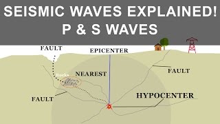
- Epicentre
The point on the Earth's surface directly above the hypocentre, where an earthquake originates.
- Hypocentre
The actual location beneath the Earth's surface where seismic energy release occurs.
- Error Ellipse
A visual representation of uncertainty in the epicentre location, indicating possible locations based on seismic data.
- Instrument Calibration
The process of adjusting instruments to ensure accurate measurements.
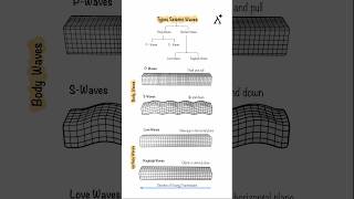
- Seismic Wave
Energy waves generated by earthquakes that propagate through the Earth's layers.
Reference links
Supplementary resources to enhance your learning experience.