
Methods of Epicentre Determination
Enroll to start learning
You’ve not yet enrolled in this course. Please enroll for free to listen to audio lessons, classroom podcasts and take practice test.
Interactive Audio Lesson
Listen to a student-teacher conversation explaining the topic in a relatable way.
Triangulation Method Using Seismic Stations
🔒 Unlock Audio Lesson
Sign up and enroll to listen to this audio lesson

Today, we’re going to learn about the triangulation method for determining the epicentre of an earthquake. Can anyone tell me what triangulation involves?

Is it the use of triangles to find a location?
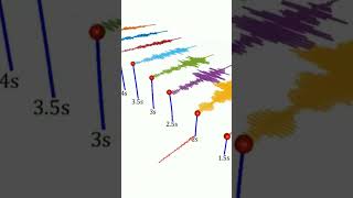
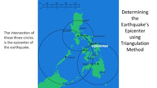
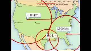
Exactly! In this method, we use the time difference between P-waves and S-waves arriving at three or more seismic stations. By calculating the distance from each station, we can draw circles on a map. The point where these circles intersect is the epicentre.

How do we calculate the distances?
Great question! We use travel-time curves to determine how far each station is from the epicentre, based on the wave arrival times. To help remember this, think of 'P' for the primary wave arriving first, and 'S' for the secondary wave arriving after.

So, if we have data from just two stations, can we still find the epicentre?
No, we need at least three stations for triangulation. With only two, we can just draw two circles that intersect in two places. That’s why more stations help increase accuracy.
To summarize, the triangulation method helps us locate the epicentre by intersecting circles based on wave arrival times. Remembering 'P' and 'S' for the waves can assist with understanding this process.
GPS and Satellite Methods
🔒 Unlock Audio Lesson
Sign up and enroll to listen to this audio lesson

Next, we're going to look at GPS and satellite methods for determining the epicentre.

How does GPS help in this process?
Good question! High-resolution GPS stations can detect ground displacement caused by seismic waves. This method allows for real-time monitoring, which is essential during an earthquake.
Does that mean we can know the epicentre almost immediately?
Correct! Real-time data helps emergency services respond faster. Think of GPS as a high-tech compass for locating an earthquake's origin.
Is this method used in all earthquakes?
While it is highly effective, it requires a network of GPS stations nearby. It's especially used in areas prone to seismic activity for immediate feedback during earthquakes.
To wrap up, GPS and satellite methods are vital for quick epicentre localization and enhance our response capabilities during seismic events.
Moment Tensor Inversion
🔒 Unlock Audio Lesson
Sign up and enroll to listen to this audio lesson
Now, let’s delve into moment tensor inversion, an advanced method of epicentre determination. Who can tell me what we mean by 'moment tensor'?
Is it related to how the earthquake affects the rocks or ground?
Exactly! Moment tensor inversion uses waveform analysis to infer both the fault mechanism and the epicentre’s location. This method is particularly effective for large earthquakes where data from many stations are available.
Why is this method useful in sparse station coverage areas?
Great question! In regions with fewer seismic stations, moment tensor inversion can analyze the waves recorded to deduce valuable information about the earthquake source.
So, do we use this method all the time?
Not for every earthquake, mostly for significant events. It helps understand the quake's mechanics better, which is crucial for future forecasting and risk assessment.
In conclusion, moment tensor inversion is important for analyzing large earthquakes and understanding how they occur, especially in areas with fewer seismic recording stations.
Introduction & Overview
Read summaries of the section's main ideas at different levels of detail.
Quick Overview
Standard
The section covers three main methods of epicentre determination: the triangulation method using seismic stations, GPS and satellite methods for real-time monitoring, and moment tensor inversion for analyzing large earthquakes. Each method plays a significant role in locating the epicentre accurately, which is vital for assessing earthquake impacts and planning responses.
Detailed
Methods of Epicentre Determination
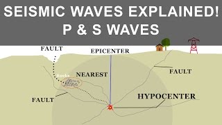
This section discusses three primary methods used for determining the epicentre of an earthquake, which is essential for understanding earthquake dynamics and implementing effective response strategies. Each method employs different technologies and principles:
24.3.1 Triangulation Method Using Seismic Stations
- Utilizes the time difference in arrival of seismic waves from the earthquake.
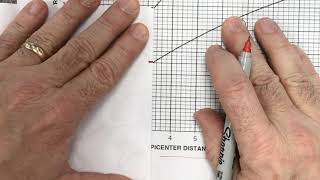
- At least three seismic stations are used to calculate distances through travel-time curves.
- Circles drawn around each station with these distances intersect at the epicentre's location.
24.3.2 Global Positioning System (GPS) and Satellite Methods
- High-resolution GPS stations track ground movement caused by seismic waves.
- This method allows for real-time monitoring and rapid localization of the epicentre.
24.3.3 Moment Tensor Inversion
- A sophisticated mathematical approach that analyzes seismic waveforms to estimate both the location of the epicentre and the fault mechanism involved.
- Especially useful for large earthquakes or in regions with limited station coverage.
Understanding these methods enhances the ability to mitigate the impacts of earthquakes, assists in planning for infrastructure resilience, and facilitates timely emergency responses.
Youtube Videos


Audio Book
Dive deep into the subject with an immersive audiobook experience.
Triangulation Method Using Seismic Stations
Chapter 1 of 3
🔒 Unlock Audio Chapter
Sign up and enroll to access the full audio experience
Chapter Content
• Based on the arrival time difference between P-waves and S-waves at three or more seismic stations.
• The distance to the epicentre is calculated for each station using travel-time curves.
• The intersection of circles (based on calculated distances) pinpoints the epicentre.
Detailed Explanation
The triangulation method is widely used to determine the epicentre of an earthquake. It works by using data from at least three seismic stations. Each station records the arrival times of different seismic waves, specifically P-waves and S-waves. P-waves, being faster, reach the station first, followed by S-waves. The difference in arrival times helps in calculating the distance of each station from the epicentre. Once these distances are determined, circles are drawn around each station, with radii corresponding to the calculated distances. The point where all circles intersect is where the epicentre is located. This method relies on the principle of triangulation, which is commonly used in navigation and surveying.
Examples & Analogies
Imagine you are trying to find a treasure buried in a vast field. You have three friends positioned at different points in the field, and each can shout when they hear your whistle. By listening to when each friend hears the sound, you can estimate how far away they are from you. If you draw circles around where each friend is standing—with each circle's radius equal to how far you estimate they're away—you can find the spot where all three circles meet—that's where you'll find your treasure, just like how seismologists find the earthquake's epicentre.
Global Positioning System (GPS) and Satellite Methods
Chapter 2 of 3
🔒 Unlock Audio Chapter
Sign up and enroll to access the full audio experience
Chapter Content
• High-resolution GPS stations detect ground displacement caused by seismic waves.
• Used in real-time seismic monitoring and rapid epicentre localization.
Detailed Explanation
GPS and satellite methods provide a modern technique for epicentre determination. High-resolution GPS stations can detect minute movements in the Earth's surface caused by seismic waves from earthquakes. These systems can operate in real-time, allowing for the immediate monitoring of seismic events. As the ground shifts due to the passing seismic waves, the GPS can measure this displacement and help pinpoint the location of the epicentre quickly. This is particularly useful in densely populated areas or for rapid response to natural disasters.
Examples & Analogies
Think of a jigsaw puzzle. Each piece represents a different location on Earth. Just like GPS pieces fitting together to create a complete picture of what is happening, GPS stations work together to track ground movements after an earthquake. When one piece moves slightly, those changes can be measured to see how the whole puzzle shifts, allowing scientists to locate the epicentre with great accuracy and speed.
Moment Tensor Inversion
Chapter 3 of 3
🔒 Unlock Audio Chapter
Sign up and enroll to access the full audio experience
Chapter Content
• A mathematical approach using waveform analysis to estimate the fault mechanism and location of the epicentre.
• Effective for large earthquakes and in areas with sparse station coverage.
Detailed Explanation
Moment tensor inversion is a more advanced method for determining the epicentre of an earthquake. This technique involves analyzing the seismic waveforms that are recorded by various seismic stations. By applying mathematical models to these waveforms, scientists can deduce not just the location of the epicentre but also the type of fault movement (or fault mechanism) that occurred during the earthquake. This method is particularly beneficial in regions where fewer seismic stations are available or for analyzing very large earthquakes that release significant seismic energy.
Examples & Analogies
Consider a detective solving a mystery. Instead of just finding the crime scene, they use clues left behind to understand how the crime was committed, who was involved, and even what happened leading up to the crime. Similarly, moment tensor inversion allows seismologists to look beyond just the location of an earthquake's epicentre and investigate the 'how' and 'why' behind it, providing a deeper understanding of the seismic events.
Key Concepts
-
Triangulation Method: A technique using at least three seismic stations to locate the epicentre based on wave arrival times.
-
GPS Method: Utilizes satellite technology to detect ground movements and monitor seismic events in real-time.
-
Moment Tensor Inversion: An advanced analytical method that estimates the epicentre and fault characteristics using the analysis of seismic waveforms.
Examples & Applications
Triangulation examples where three different seismic stations detect an earthquake's waves at different times, leading to the exact location of the epicentre.
GPS tracking systems monitoring ground displacements during real-time seismic events, providing immediate data for emergency responses.
Memory Aids
Interactive tools to help you remember key concepts
Rhymes
Seismic waves tell a tale, triangulate to not fail, GPS adds speed, while tensor checks if we need.
Stories
Imagine a detective finds clues (seismic waves) from three friends (stations) at different times. They draw lines on a map that cross at the scene of the crime—the epicentre.
Memory Tools
To remember the methods: T for Triangulation, G for GPS, and M for Moment Tensor.
Acronyms
TG-M for 'Triangulation, GPS, and Moment Tensor Methods' to remember the key techniques for epicentre determination.
Flash Cards
Glossary
- Triangulation
A method for determining the location of an epicentre using the intersection of distances calculated from seismic stations.
- Seismic Waves
Waves of energy produced by the sudden breaking of rock within the earth or an explosion, travelling through the Earth.
- GPS
Global Positioning System; a satellite-based navigation system that enables location identification and tracking.
- Moment Tensor
A mathematical representation of the seismic source that describes the forces responsible for the generation of seismic waves.
Reference links
Supplementary resources to enhance your learning experience.