
Importance of Hypocentre in Earthquake Engineering
Enroll to start learning
You’ve not yet enrolled in this course. Please enroll for free to listen to audio lessons, classroom podcasts and take practice test.
Interactive Audio Lesson
Listen to a student-teacher conversation explaining the topic in a relatable way.
Ground Motion Estimation
🔒 Unlock Audio Lesson
Sign up and enroll to listen to this audio lesson

Today, we're diving into how the hypocentre influences ground motion during an earthquake. Can anyone tell me what they think happens to the ground motion when the hypocentre is shallow?

I think shallow hypocentres cause stronger shaking at the surface.
Exactly! The closer the hypocentre is to the surface, the more intense the ground shaking. This is because the seismic waves have less distance to travel. Remember, we can use the acronym 'SAGE' – Shallow = Amplified Ground shaking Effects.

What about deep-focus earthquakes?
Great question! Deep-focus earthquakes tend to cause broader but less intense shaking. The seismic waves lose energy as they travel through rock layers. Keep this in mind: 'Distant = Duller shakes!'
In summary, remember that ground shaking intensity is highly influenced by the hypocentral depth.
Seismic Hazard Assessment
🔒 Unlock Audio Lesson
Sign up and enroll to listen to this audio lesson

Next, let’s talk about seismic hazard assessments. Who can explain why knowing the hypocentre helps in creating hazard zonation maps?

It helps determine how likely an area is to experience shaking from an earthquake?
That's right! By analyzing hypocentres, we can assess the risk of seismic activity in different regions. This information is crucial for the Design Basis Ground Motions, or DBGM, that engineers use.

So the closer the hypocentre is to a populated area, the higher the risk!
Exactly! The proximity of the hypocentre plays a major role in potential damage assessments. Remember, 'Closer = Greater Risk'!
To wrap up, understanding hypocentres allows us to quantify seismic risks and plan accordingly.
Structural Design Considerations
🔒 Unlock Audio Lesson
Sign up and enroll to listen to this audio lesson
Finally, let’s discuss structural design. Why do you think engineers must account for hypocentre locations?
To make sure buildings can withstand earthquakes!
"Right! Engineers design structures by using data from hypocentres and epicentres. Site response analyses often start from this data, ensuring buildings are resilient.
Introduction & Overview
Read summaries of the section's main ideas at different levels of detail.
Quick Overview
Standard
The hypocentre, where seismic ruptures originate, significantly influences ground motion, hazard assessments, and structural design in earthquake engineering. Understanding its importance aids in the effective assessment of risks and in designing earthquake-resistant structures.
Detailed
Importance of Hypocentre in Earthquake Engineering
In earthquake engineering, the hypocentre plays a vital role in understanding seismic activity.
Key Roles:
- Ground Motion Estimation: The hypocentral distance impacts the amplitude and frequency of ground motion experienced by structures during an earthquake. Shallow focuses typically yield stronger shaking, while deeper focuses may result in broader, less intense shaking.
- Seismic Hazard Assessment: Identifying hypocentres is essential for preparing detailed hazard zonation maps and assessing site-specific risks. Engineers use this information in their design basis ground motions (DBGM).
- Structural Design Considerations: For buildings and infrastructure, considering potential hypocentral depths and locations during design is critical. Engineers begin site response analyses based on this data, ensuring that structures can withstand anticipated seismic forces.
These points underline the necessity of understanding the hypocentre for creating effective and safe earthquake engineering solutions.
Youtube Videos

Audio Book
Dive deep into the subject with an immersive audiobook experience.
Ground Motion Estimation
Chapter 1 of 3
🔒 Unlock Audio Chapter
Sign up and enroll to access the full audio experience
Chapter Content
• The distance between the hypocentre and a structure (hypocentral distance) significantly affects the amplitude and frequency of ground motion.
• Deep-focus earthquakes may cause broader but less intense shaking.
Detailed Explanation
Ground motion estimation is crucial in understanding how an earthquake impacts buildings and infrastructure. The hypocentral distance is the vertical distance from the hypocentre to any given structure on the surface. This distance affects how strong the shaking will be and how it changes over time. For example, if a structure is closer to the hypocentre, it will likely experience stronger and more intense shaking. Conversely, deep-focus earthquakes, which occur at greater depths, can lead to shaking that is less intense but can spread out over a larger area.
Examples & Analogies
Think of ripples in a pond when you drop a stone. If you drop the stone close to the edge (the hypocentre), the ripples will be much stronger and reach the banks rapidly. However, if you drop it in the center of a large pond (a deep-focus earthquake), the ripples will be broader but less noticeable as they move outward.
Seismic Hazard Assessment
Chapter 2 of 3
🔒 Unlock Audio Chapter
Sign up and enroll to access the full audio experience
Chapter Content
• Helps in preparing hazard zonation maps and assessing site-specific risks.
• Plays a key role in design basis ground motions (DBGM).
Detailed Explanation
Seismic hazard assessment involves evaluating the risks associated with earthquakes in specific locations. By understanding the location of the hypocentre and the types of possible earthquakes, engineers can create hazard zonation maps that show areas of different risk levels. This information is crucial for designing buildings and infrastructure that can withstand seismic activities, particularly in high-risk zones. Design basis ground motions (DBGM) are critical parameters derived from this assessment that dictate how structures should be designed to remain safe during an earthquake.
Examples & Analogies
Consider a city planning for future developments by assessing flood risks. Just as engineers would map out high and low-risk flood zones to inform construction regulations, seismic hazard maps help identify where buildings should be placed and what design principles should be applied to reduce earthquake risks.
Structural Design Considerations
Chapter 3 of 3
🔒 Unlock Audio Chapter
Sign up and enroll to access the full audio experience
Chapter Content
• Buildings and infrastructure must be designed considering possible depths and locations of hypocentres in seismically active regions.
• Site response analysis often begins with hypocentre and epicentre data.
Detailed Explanation
Structural design in areas prone to earthquakes needs to take into account where the hypocentre might occur, as this influences how structures respond to seismic waves. Engineers must consider both the potential depths and positions of hypocentres to ensure that buildings can withstand earthquakes effectively. Site response analysis refers to the study of how ground movement will affect a given site, and this analysis often starts with data on the hypocentre and the epicentre to understand how the seismic waves will propagate.
Examples & Analogies
Imagine a toy building placed on a shaken table. Depending on where the shaking is coming from (the hypocentre), the toy might either tip over or remain standing. Builders must ensure the toy (or in reality, actual buildings) is stable based on where the earthquake's start point might be, ensuring effective design and safety.
Key Concepts
-
Hypocentral Distance: The distance between the hypocentre and a structure, affecting ground motion intensity.
-
Seismic Hazard Maps: Maps created using hypocentre data to assess earthquake risk.
-
Structural Design: Engineering considerations based on hypocentral depth and location to ensure safety.
Examples & Applications
When assessing the risk for high-rise buildings in California, engineers evaluate the hypocentre depths of nearby fault lines to ensure they meet safety standards.
During the 2001 Bhuj Earthquake, the shallow hypocentre led to substantial structural damage in Gujarat due to intense surface shaking.
Memory Aids
Interactive tools to help you remember key concepts
Rhymes
For seismic shakes, pay attention, focus on the depth of the tension.
Stories
Imagine a giant below the earth's crust, when it rumbles, only the nearby structures feel the thrust. The closer you are, the more you feel the sound, deep ones are mellow, they travel around.
Memory Tools
Use the acronym 'SAGE': Shallow = Amplified Ground shaking Effects.
Acronyms
Distant = Duller shakes helps remember how distance from the hypocentre affects shaking.
Flash Cards
Glossary
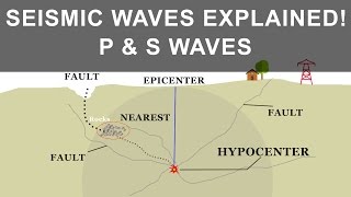
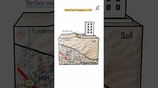
- Hypocentre
The point within the Earth where an earthquake rupture initiates, which significantly influences seismic wave behavior.
- Epicentre
The point on the Earth's surface directly above the hypocentre.
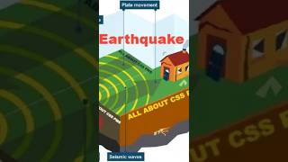
- Ground Motion
The movement of the ground as a result of seismic waves generated by an earthquake.
- Seismic Hazard Assessment
The process of evaluating the risks of seismic activity in specific areas.
- Design Basis Ground Motions (DBGM)
Seismic design criteria for structures based on expected ground motions from potential earthquakes.
Reference links
Supplementary resources to enhance your learning experience.