
Applications in Indian Seismic Design
Enroll to start learning
You’ve not yet enrolled in this course. Please enroll for free to listen to audio lessons, classroom podcasts and take practice test.
Interactive Audio Lesson
Listen to a student-teacher conversation explaining the topic in a relatable way.
Introduction to Seismic Zones in India
🔒 Unlock Audio Lesson
Sign up and enroll to listen to this audio lesson

Today, we'll discuss how India defines its seismic zones. Can anyone tell me why recognizing seismic zones is important?

Maybe to know where earthquakes are more likely to occur?
Exactly! We categorize areas into zones II to V based on their earthquake risk. Each zone indicates different levels of risk. Can anyone remember what these zones correspond to?

Zone II has low risk while Zone V has the highest risk of earthquakes.
Good! This classification helps engineers design buildings according to the expected seismic activity in that zone.

How does this affect the design of buildings?
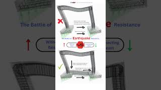
Great question! Buildings in higher risk zones need to be designed to withstand greater forces. This is where magnitude and intensity come into play.
In summary, seismic zones help in understanding risks and tailoring building codes accordingly.
Design Basis Earthquake (DBE) and Maximum Considered Earthquake (MCE)
🔒 Unlock Audio Lesson
Sign up and enroll to listen to this audio lesson

Now let's dive into DBE and MCE. Who can tell me what DBE stands for?

Is it Design Basis Earthquake?
Correct! The DBE is crucial for designing structures to endure specific earthquake forces. Can anyone think of how we estimate this?
We use magnitude data from past earthquakes?
Precisely! We also analyze intensity data to understand how severe shaking might be. What do you think MCE refers to?
Maximum Considered Earthquake?
Yes! This looks at the worst-case scenarios. Together, DBE and MCE inform the structural design process, ensuring safety.
So building codes are based on these two factors?
Exactly! They guide how we prepare for earthquakes in different areas.
In summary, DBE and MCE are essential concepts that guide seismic design codes.
Seismic Microzonation
🔒 Unlock Audio Lesson
Sign up and enroll to listen to this audio lesson
Our last topic today is about seismic microzonation. Can anyone share what they think it involves?
Is it about studying different areas to assess earthquake risks?
Exactly! Seismic microzonation involves analyzing intensity distributions to understand how different areas respond to earthquakes.
How does this help in real terms?
Great question! It helps in creating more accurate hazard maps, which are vital for urban planning and disaster management.
So these maps guide where to build?
Yes, they inform decisions on infrastructure and emergency planning, ultimately leading to safer communities.
In summary, seismic microzonation is a crucial tool for enhancing safety and preparedness against earthquakes.
Introduction & Overview
Read summaries of the section's main ideas at different levels of detail.
Quick Overview
Standard
The Bureau of Indian Standards (BIS) employs magnitude and intensity data in defining seismic zones, which are crucial for evaluating design basis earthquakes (DBE) and maximum considered earthquakes (MCE). Additionally, seismic microzonation efforts leverage intensity distributions for effective hazard mapping.
Detailed
Detailed Summary
In the context of seismic design in India, the Bureau of Indian Standards (BIS) plays a pivotal role in ensuring the safety and resilience of structures against earthquakes. This section discusses the applications of magnitude and intensity data in defining seismic zones ranging from Zone II to Zone V, which helps inform building codes and construction practices.
The Design Basis Earthquake (DBE) and Maximum Considered Earthquake (MCE) are evaluated using both magnitude records and past intensity data, allowing engineers to design structures that can withstand anticipated seismic forces. Furthermore, ongoing efforts in seismic microzonation utilize distributions of intensity to create detailed hazard maps, informing local planning and risk reduction strategies.
Overall, the integration of seismic data into design processes fosters an understanding of potential earthquake impacts, allowing for more resilient infrastructure and improved community safety.
Youtube Videos

Audio Book
Dive deep into the subject with an immersive audiobook experience.
Seismic Zones Defined by BIS
Chapter 1 of 3
🔒 Unlock Audio Chapter
Sign up and enroll to access the full audio experience
Chapter Content
• Bureau of Indian Standards (BIS) uses magnitude and intensity data to define seismic zones (Zone II to V).
Detailed Explanation
The Bureau of Indian Standards (BIS) is responsible for setting standards in various domains, including seismic design. They classify different regions of India into seismic zones based on the expected earthquake magnitude and intensity data. These zones, ranging from II to V, help engineers understand how likely an area is to experience significant seismic activity. Zone II indicates a low threat of seismic activity, while Zone V indicates a high threat, necessitating more robust design standards.
Examples & Analogies
You can think of seismic zones like weather warnings. Just as a weather service issues different alerts for thunderstorms, floods, or hurricanes, the BIS categorizes areas based on how prone they are to earthquakes. Areas in high-risk zones require buildings designed to withstand severe shaking, similar to how coastal regions prepare for hurricanes.
Design Basis Earthquake (DBE) and Maximum Considered Earthquake (MCE)
Chapter 2 of 3
🔒 Unlock Audio Chapter
Sign up and enroll to access the full audio experience
Chapter Content
• Design basis earthquake (DBE) and maximum considered earthquake (MCE) are evaluated using magnitude and past intensity records.
Detailed Explanation
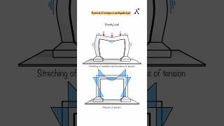
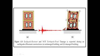
The term 'Design Basis Earthquake' (DBE) refers to the earthquake ground motion that a structure is designed to withstand without significant damage. The 'Maximum Considered Earthquake' (MCE) represents a more extreme event, one that could cause serious damage. Engineers use historical earthquake records and the corresponding magnitudes and intensities to assess both DBE and MCE, ensuring that buildings can withstand earthquakes by taking into account what has happened in the past and predicting what could happen in the future.
Examples & Analogies
Imagine planning a party in your backyard. You would consider past weather events (like rain or strong winds) when deciding what kind of tent to buy. Similarly, engineers look at past earthquakes to determine how strong structures need to be, preparing for both typical and worst-case scenarios.
Seismic Microzonation Efforts
Chapter 3 of 3
🔒 Unlock Audio Chapter
Sign up and enroll to access the full audio experience
Chapter Content
• Seismic microzonation efforts also use intensity distributions for hazard mapping.
Detailed Explanation
Seismic microzonation involves mapping the earthquake risk of specific areas based on local geological conditions and how different types of soil and rock respond to seismic waves. By analyzing intensity distributions—how ground shaking can vary based on location—engineers can create detailed hazard maps. These maps help determine the appropriate level of engineering that buildings in different neighborhoods may require, considering that not all ground conditions are the same.
Examples & Analogies
Think of seismic microzonation like selecting the right type of shoes for different terrains. If you’re hiking, you wouldn't wear flip-flops on a rocky path. Similarly, in construction, knowing the ground conditions helps engineers choose the right design approach to prevent buildings from being affected by earthquake shaking, based on how the soil behaves in that specific area.
Key Concepts
-
Seismic Zones: Categorization of areas (Zone II to V) based on earthquake risk.
-
Design Basis Earthquake (DBE): A framework for estimating the seismic forces that structures must withstand.
-
Maximum Considered Earthquake (MCE): The worst seismic event anticipated for structural design.
-
Seismic Microzonation: Analysis for creating localized hazard maps based on seismic intensity.
Examples & Applications
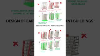
In Zone V, buildings are engineered for significant seismic forces, incorporating flexible materials to withstand shaking.
Microzonation efforts in urban areas lead to tailored construction guidelines that account for soil and geological variations.
Memory Aids
Interactive tools to help you remember key concepts
Rhymes
In southern lands, the zones we see, / II is low, while V's the key!
Stories
Imagine a city divided into five zones, where each house prepares differently for its quake. In Zone V, builders choose stronger materials. This helps them stay safe when tremors break!
Memory Tools
Remember DBE - Design Basis Earthquake, your guide to safety.
Acronyms
MCE - Maximum Considered Earthquake, for structures built to defy the quake's might.
Flash Cards
Glossary
- Seismic Zone
A classification of an area based on its risk of experiencing earthquakes.
- Design Basis Earthquake (DBE)
The earthquake ground motion assumed for the purpose of designing a structure.
- Maximum Considered Earthquake (MCE)
The largest earthquake considered in the design of a structure.
- Seismic Microzonation
The process of evaluating variations in seismic response in small areas to create detailed hazard maps.
Reference links
Supplementary resources to enhance your learning experience.