
Role of Intensity in Post-Earthquake Damage Assessment
Enroll to start learning
You’ve not yet enrolled in this course. Please enroll for free to listen to audio lessons, classroom podcasts and take practice test.
Interactive Audio Lesson
Listen to a student-teacher conversation explaining the topic in a relatable way.
Understanding Intensity in Earthquake Assessment
🔒 Unlock Audio Lesson
Sign up and enroll to listen to this audio lesson

Today, we'll explore how intensity plays a critical role in post-earthquake damage assessment. First, can someone explain what we mean by 'intensity' in the context of earthquakes?

Isn't intensity about how much shaking is felt at a certain location?
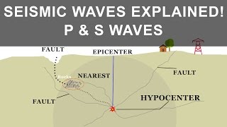
Exactly! Intensity measures the shaking experienced at specific locations, which differs from magnitude, which is a measure of energy release. Remember, we can think of it as 'how strong it feels' versus 'how strong it is'.

So, if intensity varies in different places, how does that affect damage assessment?
Great question! Intensity mapping allows us to estimate probable structural damage by showing where the shaking was strongest. This helps us understand where immediate systems are needed.

And I guess this makes for better planning in emergencies too?
Absolutely! By knowing how intense the shaking was, emergency responders can prioritize and allocate resources more effectively.

Are there any tools used for intensity mapping?
Yes, we use tools like ShakeMaps, which provide digital maps of ground shaking. This data is invaluable for assessments and decision-making post-earthquake.
To summarize, intensity assessments are crucial for estimating damage, guiding relief efforts, and enhancing building codes. Understanding how people experience shaking is key in our quest for safer structures.
Impact of Intensity on Structural Safety
🔒 Unlock Audio Lesson
Sign up and enroll to listen to this audio lesson

Continuing from our last discussion, let’s dive deeper into how intensity directly correlates with structural safety. Why do you think it’s vital to assess intensity in relation to building safety?
Because different buildings react differently to the same shaking. If a structure is poorly built, it might suffer more damage, right?
Exactly! That’s why the intensity can vary significantly in urban areas with dense or poorly constructed buildings. What’s one way we can use this information?
We can improve building codes based on what we learn from past earthquakes!
Right again! By examining the damage in areas with different intensity levels, we can enhance our codes to require safer building practices.
Does that apply to new buildings only or does it affect older buildings too?
Both! We must retrofit older buildings using data derived from intensity assessments, so they can withstand future earthquakes.
In summary, assessing intensity helps us guide building improvements and ensure both new and existing structures are better fortified against seismic risks.
Tools and Methods for Intensity Assessment
🔒 Unlock Audio Lesson
Sign up and enroll to listen to this audio lesson
Now, let’s talk about how we quickly assess intensity post-earthquake. What methods can we use?
Felt reports from people who experienced the quake?
Correct! Felt reports are crucial but rely on the public’s feedback. What else can provide reliable data?
I think field surveys would also help, right?
Yes, field surveys give us real insights into the damage on the ground. And there's instrumental recordings too, right?
Yes, those readings from seismographs measure ground motion!
That's right! Combining all these methods helps us create a comprehensive intensity map.
What happens after we create these maps?
Once we have the maps, they get distributed to emergency responders to help them make informed decisions about their response strategy.
To summarize, rapid intensity assessment blends community feedback, field observations, and instrumentation to create thorough intensity maps that guide effective emergency response.
Introduction & Overview
Read summaries of the section's main ideas at different levels of detail.
Quick Overview
Standard
The section emphasizes the importance of intensity in evaluating structural damage following an earthquake. It highlights that rapid assessments rely on felt reports, surveys, and data to create intensity maps, which are vital in guiding emergency responses and improving building codes through analysis of past earthquakes.
Detailed
Role of Intensity in Post-Earthquake Damage Assessment
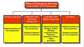
In the aftermath of an earthquake, accurately assessing the damage in affected areas is essential for effective response and recovery. Intensity assessments are essential for realizing the effects of an earthquake on structures and communities. Rapid evaluations are conducted via a combination of felt reports, field surveys, and instrumental recordings to gauge the impact experienced in various locations.
Key points of this section include:
- Intensity Mapping: This plays a central role in estimating the probable extent of structural damage. By analyzing where and how strong shaking occurred, emergency planners can prioritize areas needing immediate assistance.
- Guiding Relief Efforts: Intensity maps can direct resources to the hardest-hit areas, ensuring effective allocation of aid. Understanding the levels of shaking observed helps officials plan effective evacuation and aid strategies.
- Improving Building Codes: Learning from past earthquakes is crucial in enhancing current building practices. Insights gained from intensity assessments after seismic events help inform and refine existing building codes to mitigate future risks.
Through the use of intensity data, engineers and disaster response teams can improve the efficacy of their interventions and safeguard communities against the destructive effects of future earthquakes.
Youtube Videos


![[BCT2025 Webinar] Long Period Ground Motion in Earthquake – its Impacts, Measures and Effects 1](https://img.youtube.com/vi/0lGZlFHEbS4/mqdefault.jpg)
Audio Book
Dive deep into the subject with an immersive audiobook experience.
Rapid Damage Assessment Techniques
Chapter 1 of 2
🔒 Unlock Audio Chapter
Sign up and enroll to access the full audio experience
Chapter Content
Rapid assessment of affected areas is conducted using felt reports, field surveys, and instrumental recordings.
Detailed Explanation
After an earthquake occurs, it is essential to quickly evaluate how much damage has happened in different areas. To do this, teams rely on various methods:
- Felt Reports: These are accounts provided by residents who experienced the earthquake. People report how strong the shaking felt to them. This information helps to frame initial assessments of intensity in those areas.
- Field Surveys: Experts travel to affected regions to visually inspect buildings and infrastructure. They analyze the physical damage and track the condition of structures.
- Instrumental Recordings: Instruments like seismographs capture data on the earthquake's shaking. This provides scientific evidence of the intensity and duration of the seismic activity.
By combining these sources of information, emergency responders can form a comprehensive picture of the damage that has occurred.
Examples & Analogies
Imagine you and your friends live in several different neighborhoods. After a significant storm, you call each friend to ask how much rain they had, and they share their experiences. Then, you all decide to drive around the area to see the damage and discuss whether certain roofs are leaking. This process is similar to the rapid assessment methods used after an earthquake; by gathering information from different sources, you get a clearer overall picture of what happened.
Benefits of Intensity Mapping
Chapter 2 of 2
🔒 Unlock Audio Chapter
Sign up and enroll to access the full audio experience
Chapter Content
Intensity mapping helps:
– Estimate probable structural damage
– Guide relief operations and urban planning
– Improve building codes by learning from past failures
Detailed Explanation
Intensity mapping involves creating visual representations of how severe the shaking was across different regions during an earthquake. This process provides several key benefits:
- Estimate Probable Structural Damage: By understanding how intense the shaking was in specific areas, engineers can make educated guesses about which buildings are likely to have sustained damage.
- Guide Relief Operations and Urban Planning: Emergency services can prioritize which areas to assist first based on mapping data. This planning is vital for effective relief distribution and rebuilding efforts.
- Improve Building Codes: By analyzing the damage patterns from earthquakes, city planners and engineers can recognize what types of buildings failed and why. This information informs the development of stronger building codes to prevent future failures during earthquakes.
Examples & Analogies
Think of intensity mapping like a detailed map showing a city’s traffic patterns. If you notice that certain intersections regularly experience congestion during rush hour, city planners can focus on those areas to improve traffic flow. Similarly, intensity maps help focus resources and design efforts on areas that are most vulnerable to earthquake damage.
Key Concepts
-
Intensity Assessment: The measurement of how shaking affects different locations.
-
Emergency Planning: Utilizing intensity data to guide relief efforts and emergency response.
-
Building Codes: Regulations that must be modified based on intensity assessments from past earthquakes.
Examples & Applications
After the 2010 Haiti earthquake, intensity data revealed widespread damage in Port-au-Prince, guiding international aid efforts.
The 1906 San Francisco earthquake's intensity mapping helped improve building codes, leading to the development of modern seismic design standards.
Memory Aids
Interactive tools to help you remember key concepts
Rhymes
When the earth shakes and shivers, remember to track how it quivers!
Stories
After a big earthquake, Timmy felt his house sway. He reported it. His report, along with others, helped experts figure out where to send help.
Memory Tools
F.E.I.: Felt reports, Evaluations, and Intensity maps guide our rescue plans post-earthquake.
Acronyms
IMPACT
**I**ntensity **M**aps **P**rioritize **A**id **C**hannels **T**imely.
Flash Cards
Glossary
- Intensity
Measure of the effects of shaking produced by an earthquake at specific locations.
- Felt Reports
Subjective accounts from individuals who experienced earthquake shaking.
- Intensity Mapping
Creating visual representations of felt effects in a geographic area following an earthquake.
- ShakeMap
Digital maps that show ground shaking distribution after an earthquake.
- Building Codes
Regulations that specify the required standards for construction in an area.
Reference links
Supplementary resources to enhance your learning experience.