
Cartographic Design and Visualization Best Practices
Enroll to start learning
You’ve not yet enrolled in this course. Please enroll for free to listen to audio lessons, classroom podcasts and take practice test.
Interactive Audio Lesson
Listen to a student-teacher conversation explaining the topic in a relatable way.
Visual Hierarchy
🔒 Unlock Audio Lesson
Sign up and enroll to listen to this audio lesson

Visual hierarchy in mapping is essential. It helps to highlight the most important features using elements of design such as size, color, and contrast. Can anyone explain why visual hierarchy is important in map-making?

It’s crucial because it allows the map reader to easily identify key information at a glance!
Exactly! A well-established visual hierarchy guides viewers through the information effectively. Remember the acronym HATS – Hierarchy, Attention, Typography, and Space. This can help you remember essential factors in visual design!

What happens if the visual hierarchy is not followed?
If it's not followed, the map can become cluttered and overwhelming, making it difficult for viewers to extract the needed information. Can anyone give an example of good visual hierarchy?

A good example would be a thematic map where the main feature is highlighted brightly while secondary information is shown in a lighter shade.
Absolutely! That makes it visually clear what the map focuses on. Let’s recap: a strong visual hierarchy helps in guiding the reader's eye to the essential elements first.
Color Theory in Mapping
🔒 Unlock Audio Lesson
Sign up and enroll to listen to this audio lesson

Now, let’s delve into color theory. Color choices can dramatically impact how data is interpreted. Can anyone name the different types of color palettes used in mapping?

There are sequential, diverging, and qualitative palettes!
Correct! Sequential palettes are great for ordered data like temperature. Why do you think diverging palettes are useful?
They help to show deviations from a mean, like temperature anomalies!
Exactly! And qualitative palettes are excellent for categorical data. Remember the acronym S.D.Q - Sequential, Diverging, Qualitative to help recall these types. How would you choose a palette for a population density map?
I would use a sequential palette to show lower to higher densities!
Great thinking! Color aids comprehension and emotional response, so choose wisely. Let’s summarize: colors shape the interpretation and understanding of your map!
Typography and Labeling
🔒 Unlock Audio Lesson
Sign up and enroll to listen to this audio lesson
Typography is another cornerstone in effective mapping. What should we consider when choosing fonts and label sizes?
Legibility is really important.
Absolutely! You also want to maintain a hierarchical structure for the information. Can anyone elaborate on how to avoid clutter?
Using leader lines and dynamic labeling to keep it clear and simple can help.
Yes! Dynamic labeling adapts based on map scale, capturing clarity. Recall the acronym CLEAR – Clarity, Legibility, Engagement, Accuracy, and Readability that encompasses typography best practices.
It sounds like balancing these elements is key to effective labeling!
Indeed! Let’s recap: use legible fonts and dynamic labeling to enhance clarity while maintaining hierarchy.
Ethical Cartography
🔒 Unlock Audio Lesson
Sign up and enroll to listen to this audio lesson
Let’s talk about ethics in cartography. What responsibilities do cartographers have to their audience?
They need to ensure data is represented accurately and not manipulated.
Correct! Being transparent about data sources is crucial. Can anyone share a consequence of unethical mapping?
It could mislead the public or create panic over issues like disaster zones.
Well said! Always represent uncertainty if present. Remember the acronym T.A.P - Transparency, Accuracy, and Precision. Summarizing: ethical cartography emphasizes trustworthiness in representation and data.
Introduction & Overview
Read summaries of the section's main ideas at different levels of detail.
Quick Overview
Standard
Covering aspects such as visual hierarchy, color theory, typography, and ethical considerations, this section provides guidelines for creating effective maps. Each practice enhances the map's usability and effectiveness in conveying information.
Detailed
Detailed Summary
In cartography, effective map design is crucial for accurately conveying spatial information. This section outlines best practices in cartographic design and visualization that contribute to map clarity and effectiveness.
Visual Hierarchy
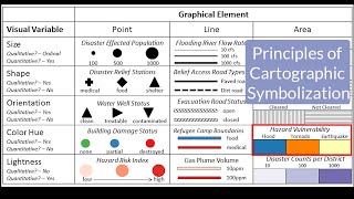
Highlighting important features is vital in ensuring users can quickly grasp the essential information. Utilizing color, contrast, and size effectively helps to establish a clear visual hierarchy in maps. Additionally, appropriate use of white space and balanced composition can enhance readability.
Color Theory in Mapping
Color plays a significant role in map representation:
- Sequential Palettes for ordered data (e.g., rainfall)
- Diverging Palettes to emphasize deviations (e.g., temperature anomalies)
- Qualitative Palettes for categorical data (e.g., land cover). Understanding and choosing the right color scheme can drastically affect how the map is interpreted.
Typography and Labeling
Using legible fonts and sizes enhances the map's readability. Hierarchical labeling ensures clarity, while avoiding clutter through dynamic labeling and the use of leader lines can facilitate better spatial understanding.
Ethical Cartography
Ethics in cartography presents the responsibility of avoiding data manipulation, misleading representations, and advocating for data transparency. Accurate representation of uncertainty and data sources is also emphasized, ensuring viewers can trust the presented information.
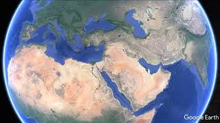
Youtube Videos


Audio Book
Dive deep into the subject with an immersive audiobook experience.
Visual Hierarchy
Chapter 1 of 4
🔒 Unlock Audio Chapter
Sign up and enroll to access the full audio experience
Chapter Content
• Emphasize important features using color, contrast, and size.
• Use of grids, white space, and balanced composition.
Detailed Explanation
Visual hierarchy refers to the arrangement of elements on a map so that the most important features stand out. To achieve this, cartographers can use techniques like color variations, contrast, and size differences. For instance, a key feature on the map can be colored in a bright shade, while less important details are shown in muted tones. The arrangement of elements is also crucial; using grids and leaving enough white space around features helps viewers focus on essential details without feeling overwhelmed.
Examples & Analogies
Think of a restaurant menu. The most popular dishes might be highlighted in a bold font and vibrant color, making them stand out from the rest of the menu options. Similarly, in map design, visual hierarchy ensures that viewers immediately recognize the most significant features.
Color Theory in Mapping
Chapter 2 of 4
🔒 Unlock Audio Chapter
Sign up and enroll to access the full audio experience
Chapter Content
• Sequential palettes: For ordered data (e.g., rainfall).
• Diverging palettes: For emphasizing deviations (e.g., temperature anomalies).
• Qualitative palettes: For categorical data (e.g., land cover).
Detailed Explanation
Color theory in mapping involves using different color schemes to represent data effectively. Sequential palettes are usually a gradient of a single color that indicates intensity or order, ideal for showing continuous data such as rainfall levels. Diverging palettes use two contrasting colors to highlight differences, perfect for representing anomalies like temperature variations. Qualitative palettes consist of different colors that have no specific order, suitable for depicting distinct categories like land cover types, ensuring clarity for categorical distinctions.
Examples & Analogies
Imagine you are creating a heat map of bakery sales in a city. You might use a gradient of yellow to red to indicate lower to higher sales (sequential palette), but if you want to highlight areas with unusually high sales versus average ones, you could use blue and red to show average and high sales respectively (diverging palette). Qualitative color choices, like different shades for various pastries, help customers differentiate between bread, cakes, and cookies.
Typography and Labeling
Chapter 3 of 4
🔒 Unlock Audio Chapter
Sign up and enroll to access the full audio experience
Chapter Content
• Legible fonts and sizes.
• Hierarchical labeling for clarity.
• Avoid clutter by using dynamic labeling and leader lines.
Detailed Explanation
Typography and labeling are critical for conveying information clearly on maps. It is crucial to choose fonts that are easy to read and to use sizes that are appropriate for the map's scale. Hierarchical labeling involves organizing label sizes and styles to denote the importance of features—larger font sizes for major cities and smaller for minor landmarks. Moreover, reducing clutter is essential, which can be achieved using dynamic labeling that appears depending on zoom levels, or leader lines that connect labels to their corresponding features, maintaining a clear view.
Examples & Analogies
Imagine trying to read a textbook cluttered with different font styles and sizes everywhere. Just like in a good textbook, a well-designed map uses clear fonts for important features (like city names) and smaller fonts for less critical points (like small towns), allowing the reader to navigate and understand the information without getting lost in overwhelming text.
Ethical Cartography
Chapter 4 of 4
🔒 Unlock Audio Chapter
Sign up and enroll to access the full audio experience
Chapter Content
• Avoid data manipulation or misleading representation.
• Represent uncertainty where applicable.
• Maintain source transparency and data accuracy.
Detailed Explanation
Ethical cartography emphasizes honesty and integrity in map-making. It is crucial to avoid manipulating data or presenting it in ways that mislead viewers. If there is uncertainty in the data—such as unverified statistics or evolving geographic features—this should be communicated clearly on the map. Furthermore, it is important to transparently disclose the sources of data and ensure that the information presented is accurate, giving the viewer confidence in what they are interpreting.
Examples & Analogies
Consider a news organization producing a map about air pollution. It's essential for them to show not just the pollution levels but also clarify any uncertainties in data collection methods. If they are unclear about where the data comes from, viewers might misinterpret the map’s implications. Ethical map-making is like a trustworthy news article—you need to back up your claims with accurate sources to maintain credibility.
Key Concepts
-
Visual Hierarchy: Importance of emphasizing key features through size, color, and layout.
-
Color Theory: Critical application of color palettes for effective data representation.
-
Typography: Importance of clear, legible fonts and labels in map-making.
-
Ethics: Responsibility to present data accurately and transparently.
Examples & Applications
A thematic map showing population density uses a sequential color ramp where lighter shades represent lower densities.
A qualitative palette is used in land use maps where distinct colors categorize different land types like commercial, residential, and agricultural.
Memory Aids
Interactive tools to help you remember key concepts
Rhymes
When mapping a site, make clarity bright, with colors and fonts that suit just right.
Stories
Imagine a cartographer named Clara who always ensured her maps were clear and colorful, knowing that the beauty of her designs led to better understanding and respect from those who used her maps.
Memory Tools
Remember HATS for visual hierarchy: Hierarchy, Attention, Typography, Space.
Acronyms
Use T.A.P for ethics
Transparency
Accuracy
Precision.
Flash Cards
Glossary
- Visual Hierarchy
The arrangement of elements in a way that implies importance.
- Color Palettes
Sets of colors used in mapping to convey data types.
- Typography
The art of arranging text to make it legible and appealing.
- Ethical Cartography
The practice of ensuring maps are accurate, transparent, and free from manipulation.
- Dynamic Labeling
Labeling that adjusts based on the context or scale to maintain clarity.
Reference links
Supplementary resources to enhance your learning experience.