
Application of Areal Rainfall in Hydrologic Studies
Enroll to start learning
You’ve not yet enrolled in this course. Please enroll for free to listen to audio lessons, classroom podcasts and take practice test.
Interactive Audio Lesson
Listen to a student-teacher conversation explaining the topic in a relatable way.
Runoff Estimation
🔒 Unlock Audio Lesson
Sign up and enroll to listen to this audio lesson

Today, we're discussing how areal rainfall is utilized in runoff estimation. Can anyone explain why knowing areal rainfall is crucial for predicting runoff?

I think it's important because runoff depends on how much rain falls over an area.
Exactly! Runoff estimation is closely linked to areal rainfall because we need to know the total rainfall in a catchment area to predict how much water will flow into rivers. Any other thoughts?

So, are there specific models we use to predict runoff?
Yes, we use rainfall-runoff models that rely on accurate areal rainfall data. Remember, 'Areal rainfall equals correct runoff!' A mnemonic to help you remember its importance.

Could we explore those models more in-depth?
Of course! We can discuss various models in future sessions, but for now, remember that without accurate areal rainfall data, our predictions about runoff will be inaccurate.
To summarize, runoff estimation relies on accurate areal rainfall data to gauge how much precipitation contributes to surface flow in river systems.
Water Balance Analysis
🔒 Unlock Audio Lesson
Sign up and enroll to listen to this audio lesson

Now let's delve into water balance analysis. What do you think is the role of areal rainfall in this context?

I guess it helps calculate how much water enters and leaves a catchment area.
Exactly! Areal rainfall informs us about incoming water, allowing us to assess whether we're gaining or losing water in the balance. Can anyone think of a simple equation that defines water balance?
Is it something like precipitation minus evaporation and runoff?
Correct! The water balance equation can be expressed as: Water In - Water Out = Change in Storage. Always remember, 'Water In is the rainfall we need to remain aware of!'
How does this affect land management?
Great question! Knowing the water balance helps manage resources effectively, guiding irrigation and conservation practices. To sum up, areal rainfall data is foundational for water balance analysis in any hydrologic study.
Design of Hydraulic Structures
🔒 Unlock Audio Lesson
Sign up and enroll to listen to this audio lesson
Next, let's discuss how areal rainfall is crucial in designing hydraulic structures, like spillways. Why do you think this information is vital?
Because we need to know how much water the structures will handle during floods.
Exactly! Engineers rely on areal rainfall to ensure that structures can withstand peak flows during extreme weather. Remember, 'Design plans rely on rainfall data!' This can help you keep its importance in mind.
How do engineers determine the design flood event?
They often refer to statistical rainfall data and perform flood frequency analysis based on areal rainfall estimates. This ensures that structures are built to last while effectively managing risks.
In summary, understanding areal rainfall helps engineers design hydraulic structures capable of handling variable flow rates and preventing potential flood damage.
Drought Analysis and Crop Planning
🔒 Unlock Audio Lesson
Sign up and enroll to listen to this audio lesson
Finally, let's examine the role of areal rainfall in drought analysis and crop planning. Why do you think it matters for farmers?
Farmers need to know if there's enough rainfall for their crops to survive!
Correct! Areal rainfall data helps farmers in planning crops based on expected precipitation. This is a critical factor in successful agricultural practices. Remember, 'Rainfall drives farming decisions!'
Can this information help during drought conditions?
Absolutely! By knowing the spatial distribution of rainfall, farmers can adjust plans accordingly, such as implementing irrigation techniques or selecting drought-resistant crops.
To conclude, areal rainfall is essential for understanding crop viability and making informed decisions for successful farming, especially in changing climates.
Introduction & Overview
Read summaries of the section's main ideas at different levels of detail.
Quick Overview
Standard
This section focuses on the multiple applications of areal rainfall in hydrologic studies, emphasizing its significance in runoff estimation, water balance analysis, hydraulic structure design, drought analysis, and flood frequency analysis. Understanding these applications aids in effective water resource management.
Detailed
Application of Areal Rainfall in Hydrologic Studies
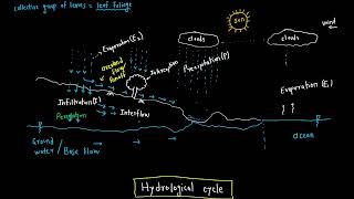
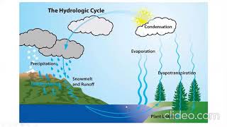
Areal rainfall plays a pivotal role in hydrologic studies by providing crucial data for various water resource applications. Its applications can be broadly categorized as follows:
- Runoff Estimation: Areal rainfall data is essential when using rainfall-runoff models. Accurate estimates of mean precipitation over an area allow for predicting how much water will runoff into rivers and streams during rain events.
- Water Balance Analysis: For catchment studies, understanding the water balance is vital. It involves assessing the inflow and outflow of water in a catchment area, where areal rainfall helps measure incoming precipitation.
- Design of Hydraulic Structures: Areal rainfall contributes significantly to the design of hydraulic structures such as spillways and culverts. Engineers utilize cumulative rainfall data to ensure these structures can handle potential flood events effectively.
- Drought Analysis and Crop Planning: In agricultural management, knowledge of areal rainfall patterns assists in planning for crops. During drought conditions, understanding precipitation distribution helps in making informed decisions about irrigation and crop selection.
- Flood Frequency Analysis: Accurate areal rainfall estimates are crucial in assessing flood risks and frequencies, allowing authorities to develop strategies for flood management and mitigation.
Understanding these applications highlights the importance of estimating areal mean precipitation and its influence on various aspects of hydrology and water resource management.
Youtube Videos


Audio Book
Dive deep into the subject with an immersive audiobook experience.
Runoff Estimation
Chapter 1 of 5
🔒 Unlock Audio Chapter
Sign up and enroll to access the full audio experience
Chapter Content
• Runoff estimation using rainfall-runoff models.
Detailed Explanation
Runoff estimation involves determining how much of the rainfall that falls on a particular area will flow off into streams, rivers, or reservoirs. Rainfall-runoff models are mathematical tools that help predict this flow based on historical rainfall data and other environmental factors. These models take into account the characteristics of the land, such as its slope, soil type, and vegetation, to estimate how much rain will be converted into runoff.
Examples & Analogies
Imagine a sponge that soaks up water. If you pour a little water on it, it absorbs most of it without dripping. However, if you pour a lot of water quickly, the sponge can overflow and let the excess water drip out. In a similar way, when rain falls on an area, the land can absorb some of it, but beyond a certain point, the excess becomes runoff. Rainfall-runoff models act like a sponge's ability to absorb water, helping us predict how much water will run off into streams.
Water Balance Analysis
Chapter 2 of 5
🔒 Unlock Audio Chapter
Sign up and enroll to access the full audio experience
Chapter Content
• Water balance analysis for catchment studies.
Detailed Explanation
Water balance analysis is a method used to understand the input, output, and storage of water within a specific area or catchment. It considers factors such as precipitation, evaporation, transpiration (water absorbed by plants), and the amount of water that flows into or out of the area. This analysis helps hydrologists assess whether a catchment is gaining or losing water over time, which is essential for managing water resources more sustainably.
Examples & Analogies
Think of a bathtub with a faucet and a drain. The water coming from the faucet is similar to precipitation, while the drain represents the runoff or water leaving the tub. By monitoring how much water is entering through the faucet and leaving through the drain, you can determine if your bathtub is filling up or emptying. Similarly, in a catchment, water balance analysis helps us determine how much water is being gained or lost.
Design of Hydraulic Structures
Chapter 3 of 5
🔒 Unlock Audio Chapter
Sign up and enroll to access the full audio experience
Chapter Content
• Design of hydraulic structures such as spillways and culverts.
Detailed Explanation
In hydrological studies, understanding areal rainfall is crucial for the design of hydraulic structures, including spillways and culverts. These structures manage water flow to prevent flooding, maintain water levels, and ensure safe drainage in urban areas. Designs need to account for the maximum expected rainfall and its distribution across an area, which influences the size and capacity of designs.
Examples & Analogies
Consider a city street designed with gutters to carry away rainwater. If the gutters are too small and a heavy rain falls, they will overflow, leading to flooding. Engineers must estimate how much rain will fall and how quickly it will drain to design the gutter system correctly. Just like those gutters, hydraulic structures must be sized appropriately based on expected rainfall to function effectively.
Drought Analysis and Crop Planning
Chapter 4 of 5
🔒 Unlock Audio Chapter
Sign up and enroll to access the full audio experience
Chapter Content
• Drought analysis and crop planning.
Detailed Explanation
Drought analysis involves assessing how prolonged periods of low rainfall affect water availability in a region. By analyzing areal rainfall, agricultural planners can determine which crops are suitable for the region based on available water resources. This allows farmers to make informed decisions about planting and managing crops, ensuring better yield and reduced risk during drought conditions.
Examples & Analogies
Imagine a farmer deciding which seeds to plant based on the weather forecast. If they know there’s likely to be little rain in the coming months, they might choose drought-resistant crops that require less water. On the other hand, if ample rainfall is expected, they might opt for more water-intensive crops. This careful planning, based on rainfall information, helps secure their harvest and sustain their livelihood.
Flood Frequency Analysis
Chapter 5 of 5
🔒 Unlock Audio Chapter
Sign up and enroll to access the full audio experience
Chapter Content
• Flood frequency analysis.
Detailed Explanation
Flood frequency analysis examines historical rainfall and runoff data to estimate how often floods of various magnitudes are likely to occur in a specific area. This information is critical for flood risk management and infrastructure design. By understanding flood risks, communities can develop better planning and emergency response strategies, which helps reduce damage caused by potential flooding.
Examples & Analogies
Think about how insurance companies set premiums based on risk. They analyze data on car accidents, home damages, and more to predict how often events might happen. Similarly, flood frequency analysis uses past rainfall and flood data to forecast future flood events, allowing communities to prepare and protect themselves, just like how a homeowner ensures their house is insured against potential fire damage.
Key Concepts
-
Runoff Estimation: Areal rainfall is vital for accurately predicting runoff in hydrologic models.
-
Water Balance: Areal rainfall informs the calculations of inflows and outflows in a water balance analysis.
-
Hydraulic Structure Design: Proper design of structures requires knowledge of expected rainfall amounts.
-
Drought Analysis: Understanding areal rainfall patterns assists in agricultural planning and drought management.
-
Flood Frequency: Areal rainfall data is crucial for assessing flood risks and frequencies.
Examples & Applications
Areal rainfall data can be used to forecast the amount of water that will enter a reservoir during a storm.
Farmers can adjust their planting schedules based on expected areal rainfall to optimize crop yields.
Memory Aids
Interactive tools to help you remember key concepts
Rhymes
If water's in the air, there's no need to despair; for crops will flourish and green shall repair.
Stories
Once upon a time, a farmer named Joe relied on rainfall for his crops. He learned to listen to the weather, ensuring he planted at the right time, optimizing his yields through the wisdom of areal rainfall data.
Memory Tools
Remember CAB: Catchment, Average rainfall, Balance—key concepts of areal rainfall application.
Acronyms
WRED
Water runoff
Resource management
Engineering design for remembering areal rainfall uses.
Flash Cards
Glossary
- Areal Rainfall
The average rainfall over a specified area, essential for hydrologic calculations.
- Runoff
Water that flows over the ground into streams and rivers after precipitation.
- Water Balance
The accounting of water entering and exiting a system, highlighting inflows and outflows.
- Hydraulic Structures
Construction designed to control or manage water flow, such as dams and spillways.
- Drought Analysis
The evaluation of water shortages based on precipitation levels and evaporation rates.
- Flood Frequency Analysis
The statistical assessment of the likelihood of flooding events based on historical data.
Reference links
Supplementary resources to enhance your learning experience.