
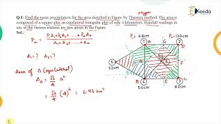
Need for Estimating Areal Mean Precipitation
Enroll to start learning
You’ve not yet enrolled in this course. Please enroll for free to listen to audio lessons, classroom podcasts and take practice test.
Interactive Audio Lesson
Listen to a student-teacher conversation explaining the topic in a relatable way.
Introduction to Areal Mean Precipitation
🔒 Unlock Audio Lesson
Sign up and enroll to listen to this audio lesson

Good morning class! Today we're talking about the need for estimating areal mean precipitation. Think about it—when we say it rained 2 inches in the city, does that reflect what happened in the entire region?

I guess not! Different parts of the region could have gotten more or less rain.
Exactly! That's why we need to estimate the average rainfall over an area rather than relying on single readings. This helps in many applications like flood forecasting and reservoir design.

Can you explain how we use this average to estimate runoff?
Certainly! Runoff is closely linked to precipitation. By averaging rainfall, we can better estimate total runoff volumes during a storm event, which is critical for managing floods.
Remember, think of the acronym 'R-FOR'—Rainfall forecasting, Operations for reservoirs, and Runoff estimations—all depend on calculating areal mean precipitation.

Got it! So, without this average, we might overestimate or underestimate the actual water we have to deal with?
Right! In summary, estimating areal mean precipitation is crucial for accurate hydrologic modeling and resource management. It allows us to prepare effectively for various hydrological events.
Applications of Areal Mean Precipitation
🔒 Unlock Audio Lesson
Sign up and enroll to listen to this audio lesson

Now let's explore where areal mean precipitation figures play a crucial role. Can anyone mention why we might need this information?

For planning irrigation systems?
Excellent point! Accurate rainfall estimates allow farmers to optimize irrigation effectively. What else?
Flood prediction, maybe?
Absolutely! Estimating runoff by considering average rainfall helps us predict flood events. If we see heavy rain over several gauges, we can alert communities.
What about reservoirs? How does this factor in?
Great question! Reservoir design depends on knowing average precipitation to ensure they can store enough water for supply and flood management. All these components come together in effective water resource management.
To recap, the applications of areal mean precipitation include runoff estimation, flood forecasting, irrigation planning, and reservoir design. Remember the acronym 'A-FIRE': Areal mean, Flood prediction, Irrigation, Reservoir, and Estimation!
Spatial Variability of Rainfall
🔒 Unlock Audio Lesson
Sign up and enroll to listen to this audio lesson
Lastly, let’s discuss why rainfall is rarely uniform. What factors might affect this variation?
Maybe the geography, like mountains?
Exactly! Topography can create orographic lifting, leading to varied precipitation. What else?
Wind patterns and storm direction?
Correct! Wind can bring storms to specific areas while leaving others dry. This is why comprehending spatial variability is vital in estimating areal mean precipitation.
And the placement of rain gauges matters too, right?
Yes! A dense and evenly distributed rain gauge network provides more accurate estimates. We often remember this by the phrase 'Gauge matters for accurate rainfall patterns!'
In summary, topography, wind patterns, storm characteristics, and gauge network density all influence how we estimate areal mean precipitation.
Introduction & Overview
Read summaries of the section's main ideas at different levels of detail.
Quick Overview
Standard
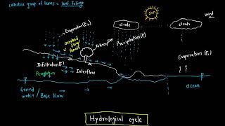
Precipitation varies widely across locations, thus making point measurements insufficient for many hydrological applications. Areal mean precipitation estimates are critical for calculating runoff volumes, flood forecasting, and planning irrigation systems, which all require a more comprehensive understanding of regional rainfall patterns.
Detailed
Overview
The need for estimating areal mean precipitation arises from the fact that precipitation collected at rain gauge stations is point-specific data and does not represent the average rainfall over a larger area. Hydrologists and engineers must have estimates of mean precipitation across catchment areas to accurately perform water balance studies, forecast floods, and design effective water resource systems.
Key Points
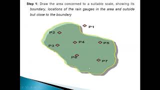
- Point Data Limitation: Rain gauges collect data at specific points, which does not account for the spatial variability of precipitation. This limitation is crucial because large-scale hydrologic models require areal averages for accurate results.
- Applications of Areal Precipitation: Areal mean precipitation estimates are used in several important domains, including:
- Estimating runoff volumes which is vital for flood prediction and management.
- Flood forecasting channels information into making timely and informed decisions during events that could lead to flooding.
- Reservoir design that ensures adequate water supply and flood control.
- Irrigation planning enables better management of agricultural water resources and contributes to drought assessments.
- Spatial Rainfall Distribution: Due to various factors such as topography and climate, it is uncommon for rainfall to be uniformly distributed over large areas. This variability necessitates precise estimation methods to ensure accurate hydrologic assessments.
Youtube Videos


Audio Book
Dive deep into the subject with an immersive audiobook experience.
Point Data Limitations
Chapter 1 of 4
🔒 Unlock Audio Chapter
Sign up and enroll to access the full audio experience
Chapter Content
• Precipitation recorded at rain gauge stations represents point data.
Detailed Explanation
Rain gauge stations collect precipitation data only at their specific locations, which means the data points are limited to these individual spots. This is known as point data. Since rainfall can vary significantly even within short distances, depending on local conditions like land features and weather patterns, relying solely on point data does not provide an accurate picture of precipitation over a larger area.
Examples & Analogies
Think of point data as a single snapshot of a larger scene. If you were to take a photo of a landscape using a focus on just one tree, while the surrounding fields and hills might be experiencing different weather, you wouldn't be able to tell what the whole environment looks like. This is similar to using rain gauges: one gauge can show rain for a single point, but it can't reveal how much rain fell in the whole area.
Importance of Areal Averages
Chapter 2 of 4
🔒 Unlock Audio Chapter
Sign up and enroll to access the full audio experience
Chapter Content
• Hydrological models and water balance studies require areal averages.
Detailed Explanation
In hydrology, it is important to understand the overall water movement and availability in a larger region rather than just at individual points. Hydrological models, which simulate water movement or storage, require an average precipitation value across an entire area (areal average) to estimate water balance accurately. This helps in making decisions for management and engineering in water resources.
Examples & Analogies
Imagine trying to understand how much water is in a farm. If you only measure rain in one small part of the farm, you might miss areas that got more or less rain. To make better farming decisions, it's necessary to know the average amount of rain over the entire farm, similar to how hydrologists need to know the average rainfall over a watershed.
Applications of Areal Precipitation
Chapter 3 of 4
🔒 Unlock Audio Chapter
Sign up and enroll to access the full audio experience
Chapter Content
• Areal precipitation is used in:
– Estimation of runoff volumes.
– Flood forecasting and reservoir design.
– Irrigation planning and drought assessment.
Detailed Explanation
Estimating areal mean precipitation is not just a theoretical exercise; it has practical applications. For instance, it helps in calculating how much water will run off into rivers and streams after a rainstorm, which is critical for flood forecasting and designing reservoirs that can hold excess water. Additionally, knowing the average rain helps farmers plan irrigation strategies to ensure crops receive enough water during dry spells.
Examples & Analogies
Consider a city that is designing a new reservoir. City planners need to know the average precipitation over the entire watershed, not just at one measurement point, to determine how much water can be captured during a storm. If they underestimate rainfall, they might build a reservoir that's too small and not able to prevent flooding.
Variability in Rainfall Distribution
Chapter 4 of 4
🔒 Unlock Audio Chapter
Sign up and enroll to access the full audio experience
Chapter Content
• Due to topographic, climatic, and spatial variability, a uniform distribution of rainfall over a large area is unlikely.
Detailed Explanation
Rainfall is influenced by various factors like topography (hills and valleys), climate conditions (temperature and weather patterns), and spatial features (location differences). This variability leads to differences in how much rain falls in different spots over a broad area. Therefore, it's rare to have equal rainfall throughout a large region, which is why estimating an average is crucial for accurate planning and resource allocation.
Examples & Analogies
Think about a mountain range where one side is sunny and dry, while the other side receives a lot of rain. If you were to measure rainfall at one point, you might miss out on understanding how different it can be just a few miles away. This difference emphasizes the need to estimate areal precipitation to capture the true picture of rainfall across that diverse landscape.
Key Concepts
-
Spatial Variability: Refers to the differences in rainfall amounts across different regions, complicating accurate hydrological analysis.
-
Point Data vs. Areal Data: Point data collected from rain gauges cannot represent areal averages needed for broader hydrological models.
-
Hydrological Applications: Areas like flood forecasting, reservoir design, and irrigation depend on accurate rainfall estimates.
Examples & Applications
Estimating the average rainfall in a watershed could guide better irrigation practices, accounting for regions with high variability.
Using areal mean precipitation to project runoff can help cities planning for flood events.
Memory Aids
Interactive tools to help you remember key concepts
Rhymes
To capture rain and not just the spot, we calculate averages ‘cause point data’s not a lot!
Stories
Imagine a thirsty village at the bottom of a mountain. One rain gauge says 2 inches, but at the top, there's a downpour! Without averaging it all out, the village might not plan for the flood that comes rushing down!
Memory Tools
Remember 'A-FIRE'! A - Areal mean, F - Flood prediction, I - Irrigation, R - Reservoir, E - Estimation!
Acronyms
Use ‘R-FOR’ to recall Rainfall forecasting, Operations for reservoirs, and Runoff estimations.
Flash Cards
Glossary
- Areal Mean Precipitation
The average precipitation over a specific area, used for hydrological studies and estimations.
- Point Data
Rainfall data collected from a specific location by a rain gauge.
- Runoff Volume
Total amount of water that flows over the ground surface resulting from precipitation.
- Flood Forecasting
The process of predicting flood events based on rainfall estimates and hydrological models.
- Irrigation Planning
The process of developing watering strategies for agricultural lands using precipitation data.
- Spatial Variability
The differences in rainfall distribution across different geographical areas.
Reference links
Supplementary resources to enhance your learning experience.