
Conclusion and Reflections
Enroll to start learning
You’ve not yet enrolled in this course. Please enroll for free to listen to audio lessons, classroom podcasts and take practice test.
Interactive Audio Lesson
Listen to a student-teacher conversation explaining the topic in a relatable way.
The Role of GIS in Education
🔒 Unlock Audio Lesson
Sign up and enroll to listen to this audio lesson

Today, we’re going to discuss how GIS tools are essential in architecture and urban planning. GIS, or Geographic Information Systems, helps in visualizing spatial data.

Can GIS really improve our design abilities?
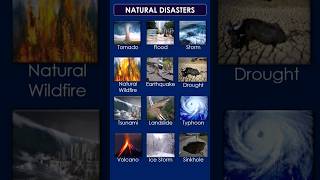
Absolutely! GIS allows you to analyze land, create drainage layouts, and understand disaster risks like landslides. Think of it as a digital map that provides crucial information.

What are some practical applications of GIS for us as students?
Great question! As Architectural students, you can use GIS for city planning, emergency management, and even environmental assessments. Remember, understanding the scale—micro and macro— of your projects is key.

How does one learn to apply GIS at a site level?
It comes through practice, integrating GIS into your projects, and utilizing satellite imagery effectively. What mnemonic might help you remember GIS benefits?

I think we could use the acronym 'MAP'—'Manage, Analyze, Present'—to remember its functions.
That's an excellent mnemonic! Let's remember MAP as we move forward in our studies.
Experiential Learning in Architecture
🔒 Unlock Audio Lesson
Sign up and enroll to listen to this audio lesson

Now, let’s discuss the importance of experiential learning. Engaging in real-world projects allows you to apply what you've learned in class.
Can you give us an example of experiential learning?
Absolutely! One example is the quick shelter built by the Yerukula tribe in just three hours. It demonstrates the principles of indigenous building techniques effectively.
How can we replicate that experience?
You could organize similar workshops where you design and construct temporary shelters. What benefits do you foresee from such hands-on experiences?
We could gain skills in teamwork and problem-solving!
Exactly! Remember, practice not just builds skills but also contributes to critical thinking and adaptability.
Can we also incorporate community feedback into our projects?
Yes! Engaging communities enhances understanding. Always aim for participatory approaches in design.
Building Knowledge Through Collaboration
🔒 Unlock Audio Lesson
Sign up and enroll to listen to this audio lesson
Collaboration is key! By sharing insights on various topics, we create a richer learning environment.
How do we effectively compile and present our findings?
One technique is creating group posters. You can summarize and visually present your research. What might be a central theme for such a poster?
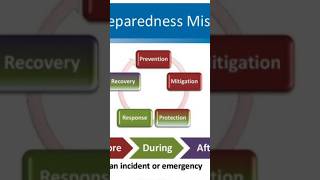
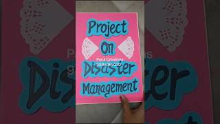
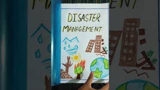
Maybe we should focus on 'Disaster Risk Reduction'?
Excellent choice! Collaborating on such themes enhances learning retention. Let's brainstorm what key points should be on that poster!
We could include definitions, strategies, and examples!
And don’t forget to add images to make it visually appealing!
Exactly! Visual aids complement information retention. Keep those in mind as you work together to create a comprehensive and engaging poster.
Role-Playing Situations in Disaster Response
🔒 Unlock Audio Lesson
Sign up and enroll to listen to this audio lesson
Role-playing is a powerful educational tool. By assuming different roles in disaster scenarios, you enhance empathy and decision-making.
What roles can we play in these scenarios?
You can take roles like community members, engineers, and planners. Each role comes with unique perspectives and responsibilities.
How do we assess the outcomes of these role-play exercises?
You can discuss what decisions were made and how they impact real-world practices. Reflective discussions post-role-play are vital. What’s a mnemonic that could help us remember the importance of diverse roles?
We could use 'TEAM'—'Together Everyone Achieves More'.
Great acronym! Remember, working as a team amplifies your learning and results!
Can we also include critiques of each role during our discussions?
Yes! Critiques foster improvement and nuanced understanding. Make sure you include that in your reflective discussions.
Introduction & Overview
Read summaries of the section's main ideas at different levels of detail.
Quick Overview
Standard
This conclusion reflects on the integration of digital tools like GIS in educational practices, emphasizing their role in shaping critical thinking and design skills among students. Additionally, it highlights the importance of hands-on experiences, community engagement, and collaborative learning in enhancing understanding and retention of complex subjects related to architecture and disaster management.
Detailed
Conclusion and Reflections
The conclusion highlights the transformative power of digital tools, particularly Geographic Information Systems (GIS), in education. These tools aid students in understanding spatial information and disaster management, which can significantly enhance their design capabilities.
The section emphasizes how experiential learning—through projects involving hands-on building techniques and community engagement—impart real-world skills to students, broadening their perspectives beyond theoretical knowledge. For instance, students have been involved in the construction of temporary shelters using indigenous techniques to demonstrate speedy and effective disaster response.
The educator reflects on past educational strategies that include field trips and interactions with local communities, noting that such experiences help students gain insights into real-world challenges faced by these communities. The necessity for enriched reading materials relevant to topics like disaster risk reduction (DRR) is also underscored. By compiling discussions and insights from students into collective learning resources, the instructor aims to bridge knowledge gaps.
Moreover, collaborative and role-playing exercises involving students from various academic backgrounds strengthen their understanding of disaster contexts and improve their decision-making abilities. The conclusion encapsulates various teaching methodologies that balance cognitive understanding with practical applications, aimed at fostering a deeper understanding of subjects critical to architecture and community planning.
Youtube Videos

Audio Book
Dive deep into the subject with an immersive audiobook experience.
Impact of Digital Tools on Learning
Chapter 1 of 10
🔒 Unlock Audio Chapter
Sign up and enroll to access the full audio experience
Chapter Content
And this is where how the tools; the digital tools are also conditioning your thinking and your understanding process and also your design ability as well.
Detailed Explanation
Digital tools greatly influence how we think and comprehend information. They shape our design skills and enhance our learning experiences. This means that the way we interact with technology, such as software for architecture or planning, conditions our approach to understanding complex problems and creating solutions.
Examples & Analogies
Imagine learning a musical instrument. If you use an app that teaches you music theory using games and interactive lessons, it's likely that you'll develop a better understanding and skill set than if you were to read a textbook alone. Similarly, digital tools make complex ideas more approachable in architecture and design.
Role of GIS in Architectural Education
Chapter 2 of 10
🔒 Unlock Audio Chapter
Sign up and enroll to access the full audio experience
Chapter Content
Now, the one of the useful tools which have come up with the geographic spatial information technology; the GIS tools where you can see from one of my students work of the hazard landslip because the satellite imagery plays an important role but now to what extent, we have to include that satellite imagery at B Arch level or we plan because they deal with much more of a larger scale projects of city planning or the regional planning, for them GIS is already within the subject, in the curriculum.
Detailed Explanation
Geographic Information Systems (GIS) are essential tools in architectural education, particularly for projects related to urban planning and environmental hazards. They provide insights through satellite imagery, which can be integrated into larger projects. This means architecture students are not only learning design but are also incorporating essential data for creating effective and safe buildings in various environmental contexts.
Examples & Analogies
Think of GIS like a video game map that gives you views from above, allowing you to see all the features of a city, including roads, rivers, and locations of hazards. An architect uses this 'map' to plan new buildings, ensuring they are placed in safe areas and designed to withstand environmental challenges.
Practical Learning Experiences
Chapter 3 of 10
🔒 Unlock Audio Chapter
Sign up and enroll to access the full audio experience
Chapter Content
Also, the GIS is one of the useful tools but one has to know that what scale you have to apply and what scale the macro-level scale to the micro-level scale, how one can understand...
Detailed Explanation
Understanding the scale of information is crucial when applying GIS. Students need to learn how to translate large, broad-scale data into specific site details. For instance, when studying a large city, they must analyze how that data impacts specific neighborhoods or buildings.
Examples & Analogies
It's similar to looking at a restaurant menu. You can see the overview of the whole restaurant, but when you decide what to order, you need to delve into the details of each dish. Just like choosing between appetizers and mains requires understanding both the menu and your appetite, architects must interpret extensive data to make informed decisions for specific sites.
Experiential Learning with Indigenous Techniques
Chapter 4 of 10
🔒 Unlock Audio Chapter
Sign up and enroll to access the full audio experience
Chapter Content
This is a disaster of shelter which has been built by yerukula tribe in 3 hours’ time...
Detailed Explanation
Real-world experiences, like learning from indigenous building techniques, provide valuable skills to students. For example, constructing a lightweight hut in a short time demonstrates efficiency and traditional knowledge, which can inform modern design practices.
Examples & Analogies
Imagine your friend learning how to cook traditional dishes from their grandmother. They not only learn the recipes but also gain insights into quick cooking techniques and using local ingredients, just like students gain skills from hands-on experience with indigenous methods.
The Value of Field Experience
Chapter 5 of 10
🔒 Unlock Audio Chapter
Sign up and enroll to access the full audio experience
Chapter Content
Also, when I was doing my research, I used to engage some of the B. Arch students along with me...
Detailed Explanation
Field experiences allow architecture students to interact with local communities, gaining insights into real-life challenges and opportunities. This interaction expands their understanding and perspective, allowing them to view problems through new lenses.
Examples & Analogies
Think of a student learning about business practices through textbooks versus a student who interns at a local company. The intern gains firsthand knowledge of real-world challenges, just as architecture students do when they work closely with community members.
Collaborative Learning Techniques
Chapter 6 of 10
🔒 Unlock Audio Chapter
Sign up and enroll to access the full audio experience
Chapter Content
So, here for B plan students in SPA, Bhopal, what we did was we given them a task of a disaster context...
Detailed Explanation
Collaborative learning strategies, such as role-playing different stakeholders in a disaster scenario, engage students actively. This allows them to explore different perspectives, fostering a deeper understanding of community dynamics in planning and architecture.
Examples & Analogies
Think of a school play where students take on different roles. A student acting as the principal sees the school from a leadership perspective, while a student as a teacher understands classroom challenges. This dynamic helps them appreciate each other’s roles, just like architecture students learn the importance of various stakeholders in disaster management.
Synthesis of Knowledge in Learning
Chapter 7 of 10
🔒 Unlock Audio Chapter
Sign up and enroll to access the full audio experience
Chapter Content
And similarly, some of the things what I also developed is; we have so much of information to read but how much to read and how to synthesize...
Detailed Explanation
Synthesis of information is vital in education. Students often face an overwhelming amount of material. By compiling and summarizing information, they learn to extract key concepts and essentials for their topics effectively, turning large volumes of data into actionable insights.
Examples & Analogies
Imagine studying for a final exam. You might read an entire textbook, but when you create a study guide with key points, it helps you to recall information more efficiently during the exam. This is exactly what students do when they synthesize information for their projects.
Key Concepts in Learning
Chapter 8 of 10
🔒 Unlock Audio Chapter
Sign up and enroll to access the full audio experience
Chapter Content
And then I give them; each of them a segment of the; this is my blackboard actually, so whatever the discussions we are getting...
Detailed Explanation
Identifying key concepts during discussions helps students understand the core aspects of their studies. This summarization aids in learning retention and facilitates deeper engagement in critical analysis.
Examples & Analogies
Think of attending a lecture where you jot down only the high points discussed. These points represent the fundamental ideas of the lecture, allowing you to review and understand the topic better later, similar to how students focus on essential keywords during their learning.
Global Perspectives in Learning
Chapter 9 of 10
🔒 Unlock Audio Chapter
Sign up and enroll to access the full audio experience
Chapter Content
So, and more importantly, I try to cover different geographical positions like Kenya, Pakistan, Australia or Turkey...
Detailed Explanation
Exploring multiple geographical contexts enriches students' understanding of architecture and planning. By studying different global cases, they learn about diverse challenges and solutions, thereby broadening their perspective and adaptability in their field.
Examples & Analogies
Traveling exposes you to varied cultures and practices. Similarly, studying global examples in architecture allows students to appreciate and learn from international strategies about design and disaster resilience.
Reflection on Teaching Methods
Chapter 10 of 10
🔒 Unlock Audio Chapter
Sign up and enroll to access the full audio experience
Chapter Content
So, this is how I was trying to develop various methods and obviously, these are all my trial and error process...
Detailed Explanation
The teaching process in architecture involves experimentation. The instructor reflects on what methods work best, continuously learning and improving their approaches to facilitate better learning outcomes for students.
Examples & Analogies
Consider how a chef experiments with various recipes to find the perfect dish. Similarly, educators need to evaluate what teaching strategies yield the best results, adapting techniques for effective learning in their classrooms.
Key Concepts
-
GIS: Geographic Information Systems that enhance design and decision-making.
-
Experiential Learning: Engaging in practical experiences to deepen understanding.
-
Collaborative Learning: Working together to construct knowledge and ideas.
-
Role-Playing: Assuming various roles to understand different perspectives in complex scenarios.
Examples & Applications
Constructing indigenous shelters in short timeframes to learn practical skills.
Creating posters summarizing disaster management concepts as collaborative effort.
Memory Aids
Interactive tools to help you remember key concepts
Rhymes
To learn and design, use the map, GIS is your helper, close the gap.
Stories
Imagine a student who built a shelter in three hours. Through hands-on work, they understood the principles of design much more deeply.
Memory Tools
Remember 'T.E.A.M' for roles: Together Everyone Achieves More.
Acronyms
G.E.T. for Learning
Gain knowledge
Engage with peers
Think critically.
Flash Cards
Glossary
- GIS
Geographic Information Systems; digital tools that analyze spatial data.
- Experiential Learning
Learning through direct experience, which promotes skill acquisition.
- Disaster Risk Reduction (DRR)
Strategies and practices aimed at preventing and minimizing disaster impact.
Reference links
Supplementary resources to enhance your learning experience.