
Remote Sensing
Enroll to start learning
You’ve not yet enrolled in this course. Please enroll for free to listen to audio lessons, classroom podcasts and take practice test.
Interactive Audio Lesson
Listen to a student-teacher conversation explaining the topic in a relatable way.
Introduction to Remote Sensing
🔒 Unlock Audio Lesson
Sign up and enroll to listen to this audio lesson

Today, we are going to talk about remote sensing. Can anyone tell me what remote sensing is?

Isn't it about collecting data from a distance?
Exactly! Remote sensing involves collecting information about the Earth using sensors from platforms like satellites and aircraft. So why do we do this?

To monitor environmental changes?
Correct! It helps us monitor and manage environmental resources effectively. Remember the term EM spectrum, which refers to the different types of electromagnetic energy used in remote sensing.
How Remote Sensing Works
🔒 Unlock Audio Lesson
Sign up and enroll to listen to this audio lesson

Let's delve into how remote sensing actually works. What’s the first step?

Making observations with sensors?
Right! We use various sensors like cameras and laser scanners to observe features of the Earth. What’s next?

Recording the observations, right?
Absolutely! We record the observations either on photographic films or transmit them to a ground station. This is crucial for correcting any distortions in the data. Can anyone think of why this correction is important?
To ensure the data we use is accurate?
Exactly! Accurate data is essential for reliable environmental assessments.
Applications of Remote Sensing
🔒 Unlock Audio Lesson
Sign up and enroll to listen to this audio lesson
Now that we understand the process, let’s talk about the applications of remote sensing. How can we use this technology?
For assessing wildlife habitats?
Yes! Remote sensing can assess habitats, track changes in land use, and monitor natural disasters. Why is this beneficial?
Because it gives us a broad view without being intrusive?
Exactly! The synoptic view allows comprehensive monitoring of vast areas efficiently. Remote sensing is key in research and resource management strategies.
Introduction & Overview
Read summaries of the section's main ideas at different levels of detail.
Quick Overview
Standard
Remote sensing involves using sensors mounted on various platforms to collect data about Earth's surface. It plays a crucial role in environmental assessment by measuring electromagnetic energy from features of interest, facilitating ecological monitoring and resource management.
Detailed
Remote Sensing
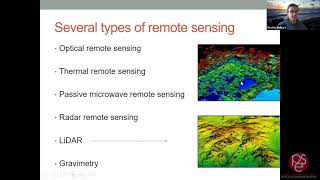
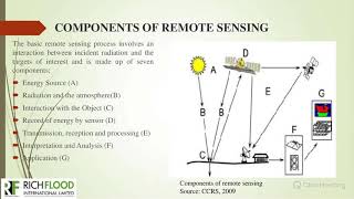
Remote sensing, as defined by Campbell (1987), is the science of deriving information about Earth's land and water from images acquired at a distance. It relies on measuring electromagnetic energy reflected or emitted from Earth’s features, which allows for the synoptic observation of areas that may be difficult to study directly. The electromagnetic spectrum is the physical basis for remote sensing, categorizing energy sources by their wavelengths.
Key Steps in Remote Sensing
- Observation: Sensors, such as cameras and lasers, are mounted on platforms like satellites or aircraft to observe features from a distance.
- Recording: Observations are recorded on mediums like photographic films or transmitted to ground stations where further correction for distortions occurs.
- Output Products: Data is processed and provided in formats compatible for user requests.
Remote sensing is a vital tool for environmental resource assessment, monitoring biotic and abiotic elements, offering advantages for comprehensive environmental management.
Youtube Videos

Audio Book
Dive deep into the subject with an immersive audiobook experience.
Definition of Remote Sensing
Chapter 1 of 4
🔒 Unlock Audio Chapter
Sign up and enroll to access the full audio experience
Chapter Content
Remote Sensing according to Campbell(1987) is the science of deriving information about the earth’s land water areas from images acquired at a distance. It relies upon measurement of electromagnetic energy reflected or emitted from the features of interest.
Detailed Explanation
Remote sensing is a scientific method that allows us to gather information about the Earth's surface from a distance, without the need to be in direct contact with the area being studied. This is achieved through imaging technology that detects and measures electromagnetic energy. This means that tools like satellites or aircraft can capture images of land, water, and other features, helping scientists and researchers learn about the environment.
Examples & Analogies
Think of remote sensing like using a camera to take pictures of a landscape from a high mountain. Just as a photographer captures a scene without stepping into it, remote sensing captures images of the Earth without needing to physically be at the location.
Electromagnetic Spectrum and Remote Sensing
Chapter 2 of 4
🔒 Unlock Audio Chapter
Sign up and enroll to access the full audio experience
Chapter Content
The Electro-magnetic spectrum (EMS) is the physical basis for Remote Sensing. It is an abstract idea and diagram of forms of electromagnetic energy for illuminating earth surface features.
Detailed Explanation
The electromagnetic spectrum includes all types of light waves, ranging from radio waves to gamma rays. In remote sensing, different wavelengths of this spectrum are used to illuminate and gather information about the Earth's surface. For example, visible light is what we see, but infrared light can provide additional data about the health of vegetation or the temperature of the land.
Examples & Analogies
Imagine different colors of light in a rainbow. Each color represents a different energy type in the spectrum. Just like how a painter uses different colors to depict a scene, scientists use various wavelengths of electromagnetic energy to understand and analyze the Earth better.
Steps in Remote Sensing
Chapter 3 of 4
🔒 Unlock Audio Chapter
Sign up and enroll to access the full audio experience
Chapter Content
The process of Remote Sensing involves 1) Making observation using sensors (camera, scanners, radiometers, radar, and lasers) mounted on platforms (ground, aircraft, satellites, balloons) which may be at considerable height from the earth surface. 2) Then, recording the observations on a suitable medium (photographic films and magnetic tapes) or transmitting/down linking the data to a ground receiving station where the data are corrected for geometric and radiometric distortions.
Detailed Explanation
Remote sensing consists of two main steps. First, sensors gather data from above the Earth's surface using various technologies like cameras or lasers mounted on different platforms. This data is then recorded on mediums like films or transmitted electronically to receiving stations. Once the data reaches the ground, it is corrected for any distortions that may have occurred during collection, ensuring accuracy.
Examples & Analogies
Picture a friend using a drone to take aerial photos of a park. The drone's camera (the sensor) captures images, which are then sent back to your friend’s smartphone (the ground receiving station). Just like your friend needs to edit and enhance the images for clarity, scientists correct their data to ensure it is accurate for analysis.
Applications of Remote Sensing
Chapter 4 of 4
🔒 Unlock Audio Chapter
Sign up and enroll to access the full audio experience
Chapter Content
Remote sensing serves as a tool for environmental resources (biotic, abiotic and cultural) assessment and monitoring. Remote sensing has some fundamental advantages that make it a veritable tool in environmental monitoring and management and impact studies.
Detailed Explanation
Remote sensing is a vital tool for assessing and monitoring various environmental resources, including biological (trees, animals), abiotic (water, minerals), and cultural resources (sites of human activity). Its key advantages include the ability to cover large areas quickly and provide valuable data for managing and protecting the environment, as well as conducting environmental impact studies.
Examples & Analogies
Think of remote sensing like a health check-up for the planet. Just as a doctor uses various tests to assess a person’s health, scientists use remote sensing to gather information about the Earth’s health by monitoring changes in land use, deforestation, or pollution levels, helping us understand and protect our environment.
Key Concepts
-
Remote Sensing: Collecting data about the Earth's surface from a distance.
-
Sensors: Devices that capture electromagnetic energy from Earth's features.
-
Electromagnetic Spectrum: The range of light wavelengths used in remote sensing.
-
Platforms: Vehicles or structures that carry sensors, enabling data collection.
Examples & Applications
Using satellites to monitor land use changes over urban development.
Employing drones equipped with cameras for wildlife habitat assessment.
Memory Aids
Interactive tools to help you remember key concepts
Rhymes
Data from space, we detect with grace; Sensors are our eyes, collecting from the skies.
Stories
In a world where scientists wanted to know the hidden secrets of forests and oceans, they sent up satellites and drones, like modern-day wizards, casting spells of light to see patterns of life from above.
Memory Tools
PES: Platforms, Electromagnetic Spectrum, Sensors - think of these as the tools of remote sensing.
Acronyms
RSET
Remote Sensing Equipment Tools - remind yourself of what you need for this science.
Flash Cards
Glossary
- Remote Sensing
The science of collecting information about the Earth's resources from a distance using sensors.
- Electromagnetic Spectrum (EMS)
A range of all types of electromagnetic radiation used in remote sensing to gather data from features on Earth.
- Sensors
Devices that detect and collect data about objects or surfaces through electromagnetic energy.
- Platforms
The structures that carry sensors, such as satellites, aircraft, or drones.
Reference links
Supplementary resources to enhance your learning experience.