
ROLE OF IT IN THE ENVIRONMENT AND HUMAN HEALTH
Enroll to start learning
You’ve not yet enrolled in this course. Please enroll for free to listen to audio lessons, classroom podcasts and take practice test.
Interactive Audio Lesson
Listen to a student-teacher conversation explaining the topic in a relatable way.
Remote Sensing
🔒 Unlock Audio Lesson
Sign up and enroll to listen to this audio lesson

Today, we're going to talk about Remote Sensing. Can anyone tell me what that means?

Isn't it about gathering information from a distance, like using satellites?
Great! Yes, Remote Sensing is the science of collecting data about our environment from afar using sensors. What kind of sensors do you think we use?

Cameras and maybe satellites?
Exactly! We use cameras, scanners, and even lasers mounted on satellites to gather data. Now, what are some steps in the Remote Sensing process?

First, we make observations, then record them?
That's correct! We observe, record, and then analyze the data. This technique helps us monitor environmental changes efficiently. Remember the acronym R-S-A: Remote, Sense, Analyze.

Thanks for that! It helps me remember the steps.
To wrap up, Remote Sensing plays a vital role in understanding our environment. Always think of how we can use it to manage natural resources better.
Geographical Information Systems (GIS)
🔒 Unlock Audio Lesson
Sign up and enroll to listen to this audio lesson

Now let’s shift our focus to GIS, or Geographical Information Systems. Who can explain what GIS does?
It’s like a computer system that analyzes spatial data, right?
Exactly! GIS helps us capture, store, and analyze data about geographical areas. Can anyone think of an example of how we might use GIS?
Maybe in planning cities or studying environmental impacts?
Spot on! GIS helps in urban planning, as well as environmental assessments. What are some specific functions it can perform?
It can identify environmental interrelationships and show changes over time.
Great observation! It also includes capabilities for site impact prediction and generating trend analyses. Remember the term G-I-S: Gather, Interpret, Share.
That’s helpful; I’ll use that to remember!
To summarize, GIS is a powerful tool that greatly aids in environmental management and planning through its analytics.
Impact on Human Health via IT
🔒 Unlock Audio Lesson
Sign up and enroll to listen to this audio lesson
Finally, let's discuss how IT impacts human health. How do you think databases help in health management?
They keep records of people's health data.
Yes! Databases play a crucial role in tracking health indicators like disease outbreaks or immunization rates. What are some examples of health databases?
Like the CDC's data on public health or hospital management systems?
Exactly! This information helps healthcare systems respond quickly to health crises. Remember the acronym D-H-I: Data, Health, Improve.
That will definitely help me remember.
To conclude, IT facilitates better health outcomes by enabling quick access to vital health information.
Introduction & Overview
Read summaries of the section's main ideas at different levels of detail.
Quick Overview
Standard
This section explores the powerful roles of information technology in supporting environmental management through remote sensing and GIS, as well as its contributions to improving human health through data systems and telemedicine. It emphasizes the importance of advanced technology in sustainable development.
Detailed
Role of IT in the Environment and Human Health
Information Technology (IT) has become essential in transforming various aspects of human life, particularly in environmental monitoring and human health management. This section identifies the key contributions of IT, focusing on two primary areas: Remote Sensing and Geographical Information Systems (GIS), along with the growing importance of databases in health management.
1. Remote Sensing:
Remote Sensing is defined as the science of acquiring information about the Earth’s surface from a distance. It employs sensors on platforms such as satellites or aircraft to collect data based on electromagnetic energy. The process includes:
- Making observations using devices like cameras and scanners,
- Recording the observations,
- Transmitting data to ground stations for analysis.
Remote Sensing is a critical tool for sustainable environmental management, providing essential data for resource assessment and monitoring.
2. Geographic Information Systems (GIS):
GIS is an advanced system designed for capturing, storing, analyzing, and managing spatial or geographical data. Its capabilities include:
- Storing multidisciplinary datasets,
- Identifying interrelationships between environmental characteristics,
- Evaluating changes over time.
Applications of GIS in Environmental Impact Assessments (EIA) include project definition, visual impact evaluation, and determining the significance of environmental impacts.
3. Databases in Health Management:
Databases play a crucial role in managing health-related information, enabling accurate tracking of birth/death rates, disease outbreaks, and public health initiatives. Advanced databases help healthcare providers deliver timely and effective treatments, supported by information technology solutions, thereby enhancing public health responses.
In summary, IT serves as a transformative tool, ushering in innovations in environmental and human health, making management more efficient and effective.
Youtube Videos


Audio Book
Dive deep into the subject with an immersive audiobook experience.
The Impact of Technology on Society
Chapter 1 of 7
🔒 Unlock Audio Chapter
Sign up and enroll to access the full audio experience
Chapter Content
Technology has played a key role in the development of human society. Modern technologies such as information technology have changed the human lifestyle.
Detailed Explanation
This chunk highlights the profound changes that technology, especially information technology (IT), has brought to human society. IT encompasses a wide range of devices and systems, impacting how we communicate, access information, and manage various aspects of our lives. These changes have transformed our daily routines, making tasks easier and more efficient.
Examples & Analogies
Think about how smartphones have revolutionized communication. Before, we relied on landline phones or letters to communicate, often resulting in delays. Now, we can instantly connect with anyone around the world through texting, social media, or video calls, showcasing the significant impact of IT on our interactions.
Role of Remote Sensing in Environmental Monitoring
Chapter 2 of 7
🔒 Unlock Audio Chapter
Sign up and enroll to access the full audio experience
Chapter Content
- Remote sensing: Remote Sensing according to Campbell(1987) is the science of deriving information about the earth’s land water areas from images acquired at a distance.
Detailed Explanation
Remote sensing involves collecting data about the Earth's surface from a distance, typically through satellites or aircraft. This technique uses sensors to capture images based on electromagnetic energy reflected off various features, like land and water. The data collected can be used to monitor environmental changes, assess natural resources, and manage land effectively.
Examples & Analogies
Consider a farmer using satellite images to monitor crop health. By analyzing the images, the farmer can identify areas that require more water or fertilizer, helping to optimize yield without wasting resources.
Process of Remote Sensing
Chapter 3 of 7
🔒 Unlock Audio Chapter
Sign up and enroll to access the full audio experience
Chapter Content
Steps: 1) Making observation using sensors (camera, scanners, radiometers, radar, and lasers) mounted on platforms (ground, aircraft, satellites, balloons).
Detailed Explanation
Remote sensing involves a series of steps: First, sensors collect data from various platforms such as satellites or drones. The sensors capture images and information about the Earth's surface. Next, this data is recorded and transmitted to ground stations for analysis. The process allows scientists and environmental managers to monitor conditions over large areas more effectively than traditional methods.
Examples & Analogies
Imagine using a drone equipped with a camera to inspect a forest for signs of disease or pest infestations. This method allows for a detailed view of the forest and can help identify areas that need treatment, demonstrating how remote sensing gives us a broader perspective on environmental monitoring.
Introduction to GIS
Chapter 4 of 7
🔒 Unlock Audio Chapter
Sign up and enroll to access the full audio experience
Chapter Content
- GIS (GEOGRAPHICAL INFORMATION SYSTEM): GIS and Environmental Impacts Assessment: Tomlin (199O) defines a GIS as ‘a configuration of computer hardware and software specially designed for the acquisition, maintenance and use of cartographic data.’
Detailed Explanation
Geographical Information Systems (GIS) are crucial tools used for managing spatial data. They consist of hardware and software that allow users to gather, analyze, and visually display data related to geographic locations. GIS can be used across various fields, including environmental management, helping to analyze data and make informed decisions based on spatial relationships.
Examples & Analogies
Think of how city planners use GIS to design new parks or roads. By mapping out existing resources and demographic information, planners can ensure that new developments meet community needs while minimizing environmental impact.
Capabilities of GIS
Chapter 5 of 7
🔒 Unlock Audio Chapter
Sign up and enroll to access the full audio experience
Chapter Content
The capabilities of GIS include storing large multidisciplinary datasets, identifying complex interrelationships, evaluating changes over time, and systematic updating of geographic data.
Detailed Explanation
GIS technology offers several powerful capabilities: it can store extensive datasets that encompass various disciplines, allows for the analysis of complex relationships between different environmental factors, and it can evaluate changes over time through historical data comparisons. This enables effective planning and decision-making regarding environmental management and development.
Examples & Analogies
Consider how emergency responders use GIS during natural disasters, like floods. They can overlay maps of flooded areas with population data to effectively plan evacuation routes and allocate resources, demonstrating GIS’s role in critical decision-making processes.
Use of GIS in Environmental Impact Assessment (EIA)
Chapter 6 of 7
🔒 Unlock Audio Chapter
Sign up and enroll to access the full audio experience
Chapter Content
In Project definition: During project identification and definition, the project proponent conducts feasibility studies and defines the usefulness of the study.
Detailed Explanation
GIS plays an important role in environmental impact assessments by helping project teams define and analyze the geographic characteristics of a proposed project site. This involves conducting feasibility studies to assess the project's potential benefits and environmental impact based on its location and surrounding features.
Examples & Analogies
Imagine a developer planning to build a new shopping center. Using GIS, they can assess the potential environmental impact by looking at factors like local wildlife habitats, traffic patterns, and nearby communities, ensuring that the project fits well within the environment.
Role of IT in Human Health
Chapter 7 of 7
🔒 Unlock Audio Chapter
Sign up and enroll to access the full audio experience
Chapter Content
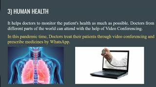
- Human health: Information technology also plays a key role in human health. It helps the doctors to monitor the health of people of that area.
Detailed Explanation
Information technology significantly aids in improving human health by allowing for better health monitoring and data management. Doctors can use IT tools to track health information, respond quickly to outbreaks of diseases, and consult with specialists remotely. This capability has become increasingly vital in managing public health and ensuring timely medical interventions.
Examples & Analogies
Consider telemedicine services that allow patients to consult a doctor from home via video calls. This service not only saves time but also ensures that specialized care can reach rural or underserved populations, exemplifying how IT enhances healthcare accessibility and responsiveness.
Key Concepts
-
Remote Sensing: Collection of data from a distance using sensors.
-
Geographical Information Systems (GIS): Analytical tools for managing and analyzing spatial data.
-
Database Management: Essential for organizing health data and improving public health responses.
-
Electromagnetic Spectrum: The foundation of Remote Sensing technology.
Examples & Applications
Satellite imagery used for forest monitoring to prevent deforestation.
GIS used for urban planning to analyze land use and environmental impacts.
Public health databases tracking the spread of diseases like COVID-19.
Memory Aids
Interactive tools to help you remember key concepts
Rhymes
Remote Sensing from afar, keeps track like a shining star.
Stories
Imagine a detective who uses high-tech gadgets to solve environmental mysteries from above. That’s Remote Sensing at work!
Memory Tools
For GIS, remember 'G-I-S': Gather, Interpret, Share.
Acronyms
D-H-I for databases
Data
Health
Improve.
Flash Cards
Glossary
- Remote Sensing
The science of collecting data about the Earth from a distance using sensors.
- Geographical Information System (GIS)
A system designed for capturing, storing, analyzing, and managing geographical data.
- Database
A collection of interrelated data that can be accessed and managed electronically.
- Electromagnetic Spectrum (EMS)
The range of all types of electromagnetic radiation used in Remote Sensing to observe Earth features.
Reference links
Supplementary resources to enhance your learning experience.