
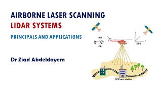
Airborne Laser Scanning (ALS)
Enroll to start learning
You’ve not yet enrolled in this course. Please enroll for free to listen to audio lessons, classroom podcasts and take practice test.
Interactive Audio Lesson
Listen to a student-teacher conversation explaining the topic in a relatable way.
Overview of Airborne Laser Scanning
🔒 Unlock Audio Lesson
Sign up and enroll to listen to this audio lesson

Airborne Laser Scanning is crucial for collecting spatial data over large areas. Who can tell me what ALS stands for?

It stands for Airborne Laser Scanning!
That's right! ALS uses LiDAR technology for rapid data acquisition. Can someone explain how it captures data?

It emits laser pulses and measures the time it takes for the pulses to return!
Exactly! This creates a point cloud dataset. Remember, LiDAR is key to this process. Let’s move on to system components.
Components of ALS
🔒 Unlock Audio Lesson
Sign up and enroll to listen to this audio lesson

ALS systems comprise several components. Can anyone name one?

The laser scanner!
Correct! The laser scanner is essential for emitting pulses. What are some other components?

GNSS for positioning and IMU for orientation!
Great job! These components work together to ensure accurate data collection.
Working Principle of ALS
🔒 Unlock Audio Lesson
Sign up and enroll to listen to this audio lesson
Now, let’s discuss the working principle of ALS. What do we need to do to achieve geo-referenced data?
We need to capture the reflected signals and integrate them with GNSS and IMU data!
Exactly! Integrating these data sets allows us to accurately calculate 3D coordinates. This process is fundamental in ALS.
So it creates a complete 3D view of the scanned area?
Yes! This point cloud represents the terrain and structures accurately.
Data Acquisition Parameters
🔒 Unlock Audio Lesson
Sign up and enroll to listen to this audio lesson
There are several data acquisition parameters in ALS. Can someone share one of them?
Flying altitude affects the point density!
Correct! The flying altitude directly influences how closely we can capture data. Any others?
Pulse frequency and scan angle also matter!
Exactly! These parameters are crucial in achieving optimal results.
Advantages and Limitations of ALS
🔒 Unlock Audio Lesson
Sign up and enroll to listen to this audio lesson
Let’s conclude by reviewing the advantages and limitations of ALS. What is one major advantage?
It can cover large areas rapidly!
That’s correct! However, what is a limitation of this method?
High operational costs!
Yes! And weather conditions can impact its effectiveness. Great discussion today!
Introduction & Overview
Read summaries of the section's main ideas at different levels of detail.
Quick Overview
Standard
This section outlines Airborne Laser Scanning (ALS) as a method to collect high-resolution spatial data over large areas, detailing its components, working principles, data parameters, advantages, and limitations. It highlights ALS's pivotal role in topographic mapping and vegetation analysis.
Detailed
Detailed Summary of Airborne Laser Scanning (ALS)
Airborne Laser Scanning (ALS) is a cutting-edge technology that utilizes LiDAR (Light Detection and Ranging) mounted on aircraft, such as fixed-wing planes or helicopters, to rapidly collect three-dimensional spatial data over extensive areas. This section begins with an overview of ALS and its system components, which include the laser scanner itself, GNSS for precise positioning, IMU for measuring orientation and motion, and a data storage unit to retain the information collected.
The principle behind ALS involves emitting laser pulses from the sensor towards the ground, capturing the reflected signals, and integrating GNSS and IMU data to determine accurate 3D coordinates, resulting in a geo-referenced point cloud dataset. Various data acquisition parameters like flying altitude, pulse frequency, scan angle, and swath width influence the quality and density of the collected data.
The significant advantages of ALS include its ability to quickly cover large and hard-to-reach areas with high point density and precision, particularly benefiting applications like topographic mapping and forest assessment. However, it also faces limitations, such as high operational costs, susceptibility to weather conditions, and reduced effectiveness in areas with occlusions, such as urban canyons and steep terrains. Overall, ALS significantly enhances spatial data acquisition capabilities, making it crucial for modern civil engineering and geospatial analysis.
Youtube Videos


Audio Book
Dive deep into the subject with an immersive audiobook experience.
Overview of ALS
Chapter 1 of 6
🔒 Unlock Audio Chapter
Sign up and enroll to access the full audio experience
Chapter Content
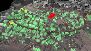
ALS systems are mounted on aircraft (usually fixed-wing or helicopters) and used to scan large areas. The laser scanner points downward and records ground and surface data over wide areas, making it suitable for topographic mapping and forest analysis.
Detailed Explanation
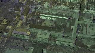
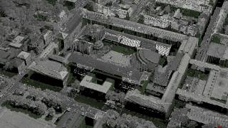
Airborne Laser Scanning, commonly known as ALS, involves using laser systems mounted on aircraft to gather data over large regions. These systems emit laser pulses downward toward the ground, measuring how long it takes for the pulses to return after hitting various surfaces. The reflected signals are then processed to create detailed maps of the terrain and its features. ALS is particularly useful in applications like topographic mapping, which involves creating a detailed representation of landforms, and forest analysis, where the structure and health of forests can be assessed.
Examples & Analogies
Think of ALS as using a flashlight in a dark room. When you shine the light (the laser pulse) on different objects, you can see how far away each object is based on how quickly the light returns. Just like that, ALS collects a wealth of information about the landscape from above, allowing scientists and engineers to create detailed and accurate maps without needing to walk through every section.
System Components of ALS
Chapter 2 of 6
🔒 Unlock Audio Chapter
Sign up and enroll to access the full audio experience
Chapter Content
• Laser Scanner: Emits laser pulses and detects returns.
• GNSS (Global Navigation Satellite System): Provides precise positioning.
• IMU (Inertial Measurement Unit): Measures the orientation and motion of the aircraft.
• Data Storage Unit: Records laser and position/orientation data for processing.
Detailed Explanation
An Airborne Laser Scanning system consists of several key components:
1. Laser Scanner: This device emits laser pulses and captures the signals that bounce back from surfaces, forming the basis for distance measurements.
2. GNSS (Global Navigation Satellite System): This system provides accurate geographic positioning, ensuring that the data collected can be referenced to real-world coordinates.
3. IMU (Inertial Measurement Unit): It tracks the aircraft's movements and orientation, which is crucial for accurately correlating the laser data with the position.
4. Data Storage Unit: This component stores all the information collected by the laser scanner and the positional data from the GNSS and IMU, ready for further processing and analysis.
Examples & Analogies
Imagine ALS as a team working together to take a group photo of a large event. The Laser Scanner is like the photographer taking the picture, capturing the details of everyone in view. The GNSS acts like the GPS in your car that ensures you know exactly where you are in the park while the event is happening. The IMU helps the photographer to know which way they are facing and if they are moving when snapping the photo. Finally, the Data Storage Unit is like a memory card that saves all those images until they are ready to be printed out or shared.
Working Principle of ALS
Chapter 3 of 6
🔒 Unlock Audio Chapter
Sign up and enroll to access the full audio experience
Chapter Content
• Laser pulses are emitted towards the ground.
• Reflected signals are captured by the receiver.
• GNSS and IMU data are integrated to calculate the precise 3D coordinates.
• The result is a geo-referenced point cloud dataset.
Detailed Explanation
The working principle of Airborne Laser Scanning involves several sequential steps: First, the laser scanner emits rapid laser pulses toward the ground. When these pulses hit a surface, they reflect back to the scanner. The time taken for the pulses to return is recorded, enabling the calculation of the distance to that surface. Additionally, data from the GNSS and IMU ensures that every point measured is accurately located in three-dimensional space. The culmination of this process results in a 'point cloud', a collection of data points that represent the geographical features of the terrain in a detailed and precise format.
Examples & Analogies
Consider Airborne Laser Scanning like throwing a ball straight down at varying objects in a park—like grass, benches, and trees. When you throw the ball, you count how long it takes to hit the ground and bounce back to your hand. This informs you about the height of the objects below. When combined with a map that shows you where you are standing (GNSS), you can create a detailed diagram of the park that shows different heights and locations of objects.
Data Acquisition Parameters in ALS
Chapter 4 of 6
🔒 Unlock Audio Chapter
Sign up and enroll to access the full audio experience
Chapter Content
• Flying altitude: Affects the point density and coverage.
• Pulse frequency: Determines how many points per second are recorded.
• Scan angle: Influences coverage and shadow effects.
• Swath width: The width of the ground area scanned in one pass.
Detailed Explanation
Data acquisition in Airborne Laser Scanning depends on several key parameters:
1. Flying altitude: The higher the aircraft flies, the broader the area scanned, but this may affect the detail (or density) of the data collected.
2. Pulse frequency: This is how many laser pulses are emitted per second—higher frequencies generate more points and yield greater detail.
3. Scan angle: The angle at which the laser is directed impacts how effectively different surfaces are captured, particularly regarding shadows that may hide certain features.
4. Swath width: This refers to the width of the ground area covered in one pass of the aircraft. A wider swath can decrease the number of required flights but might compromise detail.
Examples & Analogies
Think about a painter creating a mural from a cherry picker. If they’re high up (flying altitude), they can paint a bigger area but might miss finer details. If they move their brush faster (pulse frequency), the strokes are less precise. Depending on how they angle their brush (scan angle), parts of the mural might be obscured by other elements around it. Finally, if they work in strips (swath width), they can cover more but have to be careful with how close they get to the edges of their work to not leave gaps.
Advantages of ALS
Chapter 5 of 6
🔒 Unlock Audio Chapter
Sign up and enroll to access the full audio experience
Chapter Content
• Rapid acquisition over large and inaccessible areas.
• High point density and accuracy.
• Penetration through vegetation, useful for bare-earth modeling.
Detailed Explanation
The advantages of Airborne Laser Scanning can be summarized as follows:
1. It allows for rapid data collection over extensive areas, which is especially helpful in places that are difficult to access, such as dense forests or rugged terrains.
2. ALS provides high point density and accuracy, resulting in very detailed datasets that are valuable for analysis and modeling.
3. One significant advantage is its ability to penetrate through vegetation, which allows researchers to analyze the ground beneath forests or thick bushes—this capability is vital for tasks like creating 'bare-earth' models that show the terrain without vegetation obscuring it.
Examples & Analogies
Imagine trying to take a panoramic photo of a mountain range from a distant viewpoint (ALS). You can capture the vastness of the landscape without needing to hike through the jungles or valleys between the mountains. In this way, ALS acts like a drone with a high-resolution camera that can hover over areas that would be hard to reach on foot, ensuring you get sharp, detailed images that reveal hidden features without disturbing the environment.
Limitations of ALS
Chapter 6 of 6
🔒 Unlock Audio Chapter
Sign up and enroll to access the full audio experience
Chapter Content
• High operational cost.
• Limited by weather conditions and flight regulations.
• Reduced effectiveness in urban canyons and steep terrain due to occlusions.
Detailed Explanation
While Airborne Laser Scanning has many strengths, it also comes with limitations:
1. One of the most significant drawbacks is the high operational cost associated with the aircraft, equipment, and personnel required to conduct ALS missions.
2. Weather conditions also impact the ability to collect data—cloud cover, rain, or high winds can interfere with laser operation and data accuracy.
3. Finally, ALS can struggle in urban environments or steep terrains where buildings and other structures can block the laser signals from reaching the ground, leading to incomplete or inaccurate data in those areas.
Examples & Analogies
Consider ALS like a photographer trying to shoot a wedding in a heavy rainstorm. Even if they have an expensive camera (high operational cost), they may find it hard to capture good images if the weather isn’t cooperating. Similarly, getting good photos of vibrant flower arrangements can be tricky if someone is standing in front of them (urban canyons) or if it’s a steep outcrop that blocks the view. These challenges mean that even great technology for data acquisition has its limits.
Key Concepts
-
ALS: A method for 3D spatial data acquisition using aircraft.
-
Point Cloud: Representations of collected data points in 3D space.
-
GNSS: Essential for GPS precision in mapping.
-
IMU: Measures orientation, critical for accurate data capture.
Examples & Applications
ALS can be used for creating digital elevation models of forests.
ALS is utilized in urban planning to assess infrastructure and land usage.
Memory Aids
Interactive tools to help you remember key concepts
Rhymes
Laser beams in the sky, capturing terrain from high.
Stories
Imagine a helicopter flying over a forest, sending out laser beams that bounce back, creating a magical 3D map of the land below.
Memory Tools
LIG - Laser, IMU, GNSS: Remember the key components of ALS.
Acronyms
A.L.S. - Aerial Laser Surveying.
Flash Cards
Glossary
- Airborne Laser Scanning (ALS)
A LiDAR method using aircraft to collect spatial data over large areas.
- LiDAR
Light Detection and Ranging, a technology to measure distances using laser pulses.
- Point Cloud
A collection of data points in 3D space produced by laser scanning.
- GNSS
Global Navigation Satellite System, used for precise positioning.
- IMU
Inertial Measurement Unit, measures the sensor's orientation and motion.
Reference links
Supplementary resources to enhance your learning experience.