
Basics of Laser Scanning
Enroll to start learning
You’ve not yet enrolled in this course. Please enroll for free to listen to audio lessons, classroom podcasts and take practice test.
Interactive Audio Lesson
Listen to a student-teacher conversation explaining the topic in a relatable way.
Laser Scanning Definition
🔒 Unlock Audio Lesson
Sign up and enroll to listen to this audio lesson

Welcome everyone! Today, we’re diving into the basics of laser scanning. Can anyone tell me what laser scanning is?

I think it’s a way to measure distances using lasers.
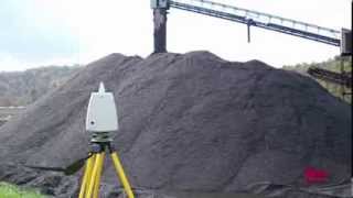
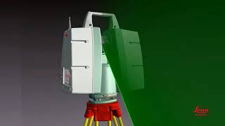
Great start! Yes, it's a method used to capture high-resolution spatial data by emitting laser pulses. When these pulses hit an object and return, we can determine distances based on the speed of light. This creates what we call a 3D point cloud.

What is a point cloud exactly?
A point cloud is a set of data points in space, representing the external surface of objects. These are essential in analyzing and modeling terrains and structures. Remember, 'P' for Point Cloud stands for 'Points in space'!
Key Terminologies
🔒 Unlock Audio Lesson
Sign up and enroll to listen to this audio lesson

Now, let's delve into some key terminologies. What do you think LiDAR stands for?

I remember it's Light Detection and Ranging.
Exactly! And what about 'Range'?

It's the distance from the sensor to the target, right?
Spot on! Also, the 'Scan Rate' is how many laser pulses are emitted per second. Think of it as how fast we are scanning the environment. Can anyone remember what 'Field of View' means?
It’s the area we can scan at one time, like looking through a wide-angle lens!
Well done! Remember, a good analogy to think about is a flashlight beam; the wider the beam, the more you can see!
Applications of Laser Scanning
🔒 Unlock Audio Lesson
Sign up and enroll to listen to this audio lesson
Finally, let’s discuss why understanding laser scanning is crucial. How do you think this technology is used in real-world applications?
Is it used for creating maps and structures?
Exactly! Laser scanning assists in digital elevation modeling, urban planning, and even in disaster assessments. It's a cornerstone for collecting and analyzing geospatial data swiftly and accurately.
So, it’s very important for civil engineering too?
Yes! Think of it as the 'eyes' of civil engineering, providing detailed insight into terrains and infrastructures. Always remember, in civil engineering, detailed data equals better planning and execution.
Introduction & Overview
Read summaries of the section's main ideas at different levels of detail.
Quick Overview
Standard
This section explores the basics of laser scanning, defining key concepts like LiDAR and point clouds, explaining how laser pulses are used to measure distances, and outlining important terminologies including range, scan rate, and field of view. Understanding these foundational elements is essential for applications in civil engineering and geospatial analysis.
Detailed
Basics of Laser Scanning
Laser scanning, commonly known as LiDAR (Light Detection and Ranging), is a crucial technique in modern civil engineering and geospatial studies. It captures high-resolution spatial data by emitting laser pulses towards an object and measuring the time taken for the pulses to return. This technique calculates distances based on the speed of light, enabling the generation of three-dimensional point clouds. This section provides a foundational overview of key terminologies associated with laser scanning, including:
- LiDAR: A method leveraging light to measure distances finely.
- Point Cloud: A collection of data points in space resulting from laser scanning.
- Range: The distance from the scanner to an object.
- Scan Rate: The frequency at which laser pulses are emitted.
- Field of View (FoV): The angular area that the scanner can cover.
These foundational concepts are vital as laser scanning supports various applications, such as digital elevation modeling and urban planning.
Youtube Videos


Audio Book
Dive deep into the subject with an immersive audiobook experience.
Definition and Concept
Chapter 1 of 2
🔒 Unlock Audio Chapter
Sign up and enroll to access the full audio experience
Chapter Content
Laser scanning is a method for capturing high-resolution spatial data by emitting laser pulses and measuring the time it takes for the pulses to return after hitting an object. The distance is calculated based on the speed of light, enabling the creation of 3D point clouds.
Detailed Explanation
Laser scanning is a technology used to gather detailed spatial data about an object or environment. It works by sending out laser beams that bounce back after hitting a surface. By measuring the time it takes for the laser to return, we can calculate how far away the surface is due to the known speed of light. This data helps create a 'point cloud,' which is a digital collection of points in three-dimensional space that represents the scanned object or area.
Examples & Analogies
Think of laser scanning like using a flashlight in the dark. When you shine the light on an object, you can see its outline. If you could measure how long it takes for that light to reflect back to you, you would get a better understanding of how far away the object is. Each time the light bounces back gives you detailed data about the object, just like a laser scanner.
Key Terminologies
Chapter 2 of 2
🔒 Unlock Audio Chapter
Sign up and enroll to access the full audio experience
Chapter Content
• LiDAR: Light Detection and Ranging
• Point Cloud: A set of data points in space produced by laser scanners.
• Range: Distance between the sensor and the target.
• Scan Rate: Number of laser pulses emitted per second.
• Field of View (FoV): Angular extent of the scanning area.
Detailed Explanation
Understanding the language of laser scanning is essential. Here are some important terms:
- LiDAR is the overarching technology that involves measuring distances with laser light.
- A Point Cloud is like a digital model made up of many individual points where the laser beam has bounced off objects. Each point has specific coordinates.
- Range is how far the laser scanner can measure to its target.
- The Scan Rate tells us how quickly the scanner can send out laser pulses in a second, which affects how much data it collects over time.
- The Field of View (FoV) is the angle at which the laser scanner can capture data, similar to how wide a camera's lens can capture an image.
Examples & Analogies
Imagine you're in a large room trying to photograph as much of it as possible with your smartphone. The FoV would be how wide your camera can see without moving. If your phone takes photos every second (that's the scan rate), and you have a clear view of the far walls (the range), you’d end up capturing a detailed 3D image of the entire room—just like how a laser scanner creates a visual map of its surroundings!
Key Concepts
-
LiDAR: Technology using laser to measure distances and create 3D models.
-
Point Cloud: Representation of surfaces using a collection of data points.
-
Range: Measurement of distance from scanner to object.
-
Scan Rate: Frequency of emitted laser pulses.
-
Field of View: The area that can be scanned by the device.
Examples & Applications
LiDAR is used in topographic mapping to create detailed terrain models.
Point clouds generated from laser scanning can be used for 3D modeling of buildings and infrastructure.
Memory Aids
Interactive tools to help you remember key concepts
Rhymes
Laser beams flying high, catch that distance in the sky!
Stories
Imagine a scientist in a lab who sends out a laser beam to find distances. As it returns, the data points create a beautiful cosmic cloud of information representing the world around them.
Memory Tools
Remember 'LPF'S: Laser, Point Cloud, Field of View for basics of Laser Scanning.
Acronyms
LiDAR – Light Detection and Ranging, let’s remember this for all our scanning discussions!
Flash Cards
Glossary
- LiDAR
Light Detection and Ranging; a technology that uses light in the form of a pulsed laser to measure ranges (variable distances) to the Earth.
- Point Cloud
A set of data points in space produced by laser scanning, representing surfaces and structures.
- Range
The distance measured from the sensor to the target object.
- Scan Rate
The number of laser pulses emitted by the laser scanner in one second.
- Field of View (FoV)
The angular extent of the observable area that can be scanned by the device.
Reference links
Supplementary resources to enhance your learning experience.