
Specialized Applications of Laser Scanning in Civil Engineering
Enroll to start learning
You’ve not yet enrolled in this course. Please enroll for free to listen to audio lessons, classroom podcasts and take practice test.
Interactive Audio Lesson
Listen to a student-teacher conversation explaining the topic in a relatable way.
Structural Health Monitoring
🔒 Unlock Audio Lesson
Sign up and enroll to listen to this audio lesson

Today we are going to learn about one of the essential applications of laser scanning in civil engineering, which is structural health monitoring. Can anyone tell me why monitoring structures is vital?

To ensure they are safe and to prevent collapse!
Exactly! Laser scanning allows us to detect millimeter-level deformations in structures over time. This periodic scanning generates datasets that help detect any changes. Does anyone want to guess how often these scans are typically performed?

Maybe once a year?
Good guess! It can actually vary depending on the structure and its needs. More frequent scans might be necessary for critical structures. Remember the acronym S.H.M. for Structural Health Monitoring; it’s crucial for justifying safety in engineering.

What kind of structures do we usually monitor?
Great question! We monitor buildings, bridges, dams, and towers. Any other examples that come to mind?

What about skyscrapers?
Exactly! To recap, laser scanning in SHM can detect changes and ensure structural safety through precise measurements. Remember, S.H.M. helps prevent catastrophic failures.
Road and Highway Corridor Mapping
🔒 Unlock Audio Lesson
Sign up and enroll to listen to this audio lesson

Let's now move on to road and highway corridor mapping. Why do you think capturing details like lane markings and signage is essential for urban planning?
Because it helps in designing safe roads and understanding traffic flow?
Spot on! TLS and MLS technologies help capture important features such as curbs, pavements, and signage. Can anyone tell me what a digital terrain model (DTM) is?
Is it a 3D representation of the terrain?
Yes! A DTM is crucial for road design and maintenance, allowing engineers to visualize and plan effectively. Remember the term R.M.C. for Road Mapping Corridor.
How do we ensure these scans are accurate?
Great inquiry! Accuracy depends on several factors, including the point density and the settings used during the scan. Always remember; more data isn't always better; it must be relevant!
So, scanning can help prevent road accidents too?
Absolutely! Well done! To summarize, road mapping is essential for infrastructure planning and safety. R.M.C. is your acronym to recall this application.
Tunnel and Subway Inspection
🔒 Unlock Audio Lesson
Sign up and enroll to listen to this audio lesson
Let's discuss tunnel and subway inspection now. What challenges do you think engineers face in underground structures?
The lack of GPS signals!
That's right! Laser scanning is incredibly useful where GNSS doesn't work. Can anyone suggest how we can analyze tunnel linings using laser data?
By using the cross-sectional analysis feature?
Exactly! It allows for detailed mapping of surface deformations and embedded utilities. Remember T.A.S. for Tunnel Analysis and Scanning. It's an easy way to remember this application.
What about safety checks in tunnels?
Fantastic point! Regular inspections can prevent accidents by identifying potential issues early on. Today’s key takeaway is that T.A.S. ensures safety and efficiency in tunnel inspections.
I can see how important this is for urban transport systems!
Exactly! Remember, T.A.S. is critical in ensuring safe and effective transport systems underground.
Construction Progress Tracking
🔒 Unlock Audio Lesson
Sign up and enroll to listen to this audio lesson
Now, let's examine how laser scanning helps in construction progress tracking. Why might contractors want to compare as-built to planned dimensions?
To ensure the project is on track and within specifications!
Exactly! It’s vital for quality control. How can laser scans assist in resolving disputes?
By providing precise data that shows what was built versus what was planned?
Spot on! This can be integrated into BIM, or Building Information Modeling, which enhances communication. Remember C.P.T. for Construction Progress Tracking; it's a vital acronym.
What happens if the scans show significant deviations?
Great question! Significant deviations may trigger further inspections and potentially delays until issues are resolved. Always aim for accuracy in C.P.T.
Got it! This seems critical for keeping projects on schedule!
Absolutely! So always keep C.P.T. in mind for successful project management during construction.
Heritage and Archaeological Documentation
🔒 Unlock Audio Lesson
Sign up and enroll to listen to this audio lesson
Finally, let's talk about the role of laser scanning in heritage and archaeological documentation. Why is preserving these sites important?
To maintain cultural history and avoid loss!
Exactly! Laser scanning preserves fragile sites digitally. How does this advance our understanding of these sites?
It allows for virtual walkthroughs and gives us 3D models to study!
Correct! This is vital for education and future restoration planning. Remember H.A.P. for Heritage Archaeological Preservation to recall this application.
Can it help with ongoing excavations?
Yes, absolutely! It helps document changes over time. Remember, H.A.P. ensures that our cultural heritage is preserved for future generations.
This is such a valuable technology!
Indeed! To summarize, H.A.P. emphasizes the significance of cultural preservation using laser scanning techniques.
Introduction & Overview
Read summaries of the section's main ideas at different levels of detail.
Quick Overview
Standard
This section covers key specialized applications of laser scanning in civil engineering, including structural health monitoring for detecting deformations and cracks, corridor mapping for roads and highways, underground inspections, construction progress tracking, and the preservation of heritage sites through detailed scanning and 3D modeling.
Detailed
Specialized Applications of Laser Scanning in Civil Engineering
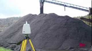
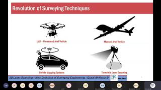
Laser scanning technology, particularly through TLs and MLS, has opened avenues for specialized applications that enhance the efficiency and accuracy of civil engineering practices. This section highlights various implementations:
1. Structural Health Monitoring
Laser scanning allows engineers to monitor structural integrity with millimeter-level accuracy. Applications include tracking deformations, cracks, and settlements in buildings, bridges, dams, and towers by generating temporal datasets that facilitate change detection over time.
2. Road and Highway Corridor Mapping
TLS and MLS are extensively used for mapping highways and urban roads effectively. This process captures critical features such as curbs, pavements, poles, and signage, generating digital terrain models (DTMs) essential for design and maintenance.
3. Tunnel and Subway Inspection
In environments where GNSS signals are unavailable, laser scanning finds utility in inspecting underground structures. It helps with cross-sectional analysis, detecting surface deformations, and mapping utilities and embedded elements in subway systems.
4. Construction Progress Tracking
Regular laser scans during construction phases enable contractors to validate as-built models by comparing planned versus actual dimensions. This process aids in resolving disputes through the integration of scan data with Building Information Modeling (BIM).
5. Heritage and Archaeological Documentation
Laser scanning is pivotal in preserving cultural heritage sites. It enables the digital preservation of fragile sites, supports virtual walkthroughs, and assists in restoration planning using detailed 3D models.
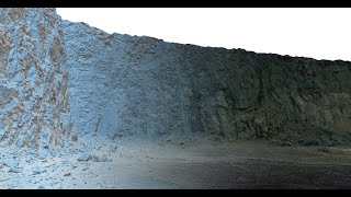
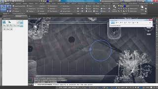
Youtube Videos


Audio Book
Dive deep into the subject with an immersive audiobook experience.
Structural Health Monitoring
Chapter 1 of 5
🔒 Unlock Audio Chapter
Sign up and enroll to access the full audio experience
Chapter Content
Laser scanning provides millimeter-level accuracy for monitoring structural deformation, cracks, and settlements in buildings, bridges, dams, and towers. Periodic scanning allows the generation of temporal datasets for comparison over time to detect changes.
Detailed Explanation
In Structural Health Monitoring, laser scanning is used to closely observe buildings and structures. This technology measures slight movements or cracks with precise millimeter accuracy. By scanning periodically, engineers create datasets that track changes over time, making it easier to identify issues that may require attention.
Examples & Analogies
Imagine a doctor conducting regular check-ups on a patient to monitor their health. Each check-up provides data on the patient's condition, helping the doctor detect any signs of illness early. Similarly, regular laser scans create a health profile for structures, alerting engineers to potential problems before they become severe.
Road and Highway Corridor Mapping
Chapter 2 of 5
🔒 Unlock Audio Chapter
Sign up and enroll to access the full audio experience
Chapter Content
TLS and Mobile Laser Scanning (MLS) are widely used in highway and urban road mapping:
- Captures features like curbs, pavements, poles, and signage.
- Generates digital terrain models (DTMs) for design and maintenance.
- Enables automated extraction of lane markings and roadside furniture.
Detailed Explanation
Laser scanning technology, particularly TLS and MLS, is instrumental in mapping roadways. It captures detailed information about features such as curbs, pavements, and traffic signs. This data helps create digital terrain models that are vital for road design and maintenance. Additionally, the technology can automatically identify and extract lane markings, contributing to safer road conditions and precise planning.
Examples & Analogies
Think of a meticulous artist sketching a landscape. By accurately drawing every element, the artist ensures everything is in place. Similarly, laser scanning captures every road feature, helping planners create safer and more efficient road designs, akin to an artist ensuring every detail is captured perfectly.
Tunnel and Subway Inspection
Chapter 3 of 5
🔒 Unlock Audio Chapter
Sign up and enroll to access the full audio experience
Chapter Content
Laser scanning is deployed in underground structures where GNSS is not available. Benefits include:
- Cross-sectional analysis of tunnel linings.
- Detection of surface deformations.
- Mapping utilities and embedded elements in subways.
Detailed Explanation
In tunnels and subways, laser scanning is valuable because GPS signals cannot reach underground. This equipment can analyze cross-sections of tunnel walls, detect any deformations that may signal structural issues, and map out utilities and other components embedded in the structures. This ensures that any potential problems can be identified and resolved before they lead to significant failures.
Examples & Analogies
Imagine a doctor performing an MRI on a patient. The MRI provides a detailed view of the inside of the body without cutting into it. Likewise, laser scanning allows engineers to get a clear, detailed picture of tunnels without needing to dig or disrupt the environment.
Construction Progress Tracking
Chapter 4 of 5
🔒 Unlock Audio Chapter
Sign up and enroll to access the full audio experience
Chapter Content
By performing regular scans during the construction phase:
- Contractors can validate as-built models.
- Compare planned vs. actual dimensions.
- Resolve disputes through scan-to-BIM integration.
Detailed Explanation
During the construction phase, conducting regular laser scans helps contractors check if the work matches the original plans. This validation process ensures that everything is built according to specifications. If discrepancies arise between what was planned and what was constructed, these can be identified early, facilitating resolution and minimizing disputes.
Examples & Analogies
Think of a teacher checking a student's progress report regularly. If a student is falling behind in a subject, the teacher can intervene promptly, helping the student get back on track. Similarly, laser scanning acts as a progress report for construction, catching issues early so they can be addressed swiftly.
Heritage and Archaeological Documentation
Chapter 5 of 5
🔒 Unlock Audio Chapter
Sign up and enroll to access the full audio experience
Chapter Content
Laser scanning plays a major role in cultural heritage:
- Preserves fragile sites digitally.
- Enables virtual walkthroughs.
- Allows restoration planning using 3D modeling.
Detailed Explanation
In the field of cultural heritage, laser scanning is crucial for preserving historically significant sites. By creating detailed digital models, fragile structures can be preserved without physical interference. This technique allows people to take virtual tours of these sites and assists in planning any necessary restoration efforts using accurate 3D models.
Examples & Analogies
Consider a museum that digitizes its exhibits. By capturing everything digitally, people across the globe can view these exhibits online, ensuring that even delicate pieces are kept safe. Similarly, laser scanning protects heritage sites, allowing virtual visits while safeguarding the physical sites from damage.
Key Concepts
-
Millimeter-level accuracy in structural health monitoring allows for precise evaluation of structures.
-
Digital Terrain Models (DTMs) are essential for effective road and highway mapping.
-
Laser scanning enhances safety inspections within tunnels where GNSS is unavailable.
-
Construction Progress Tracking (C.P.T.) ensures compliance with planned designs.
-
Heritage Archaeological Preservation (H.A.P.) is vital for cultural site documentation.
Examples & Applications
Using laser scanning technology to monitor a bridge's structural integrity over time and detect cracks.
Mapping a highway corridor to create digital terrain models for optimizing road maintenance.
Memory Aids
Interactive tools to help you remember key concepts
Rhymes
For roads we scan, the features grand, planning safe, with a steady hand!
Stories
Once, in a town, a clever engineer used laser scanning to catch structural cracks in a broken bridge, saving a disaster!
Memory Tools
R.H. S.H.M. for Remember Health Structure Monitoring!
Acronyms
H.A.P. - Heritage Archaeological Preservation!
Flash Cards
Glossary
- Structural Health Monitoring
A process using laser scanning to evaluate and track the integrity of structures over time.
- Digital Terrain Model
A 3D representation of the terrain features captured during laser mapping.
- Laser Scanning
A technology that captures high-resolution spatial data through laser pulses.
- Building Information Modeling (BIM)
A digital representation of physical and functional characteristics of a facility.
- Mobile Laser Scanning (MLS)
A method of collecting 3D data using a laser scanner mounted on a mobile platform.
Reference links
Supplementary resources to enhance your learning experience.