
Emerging Trends in Laser Scanning
Enroll to start learning
You’ve not yet enrolled in this course. Please enroll for free to listen to audio lessons, classroom podcasts and take practice test.
Interactive Audio Lesson
Listen to a student-teacher conversation explaining the topic in a relatable way.
Mobile Laser Scanning (MLS)
🔒 Unlock Audio Lesson
Sign up and enroll to listen to this audio lesson

Today, we're diving into Mobile Laser Scanning, or MLS. Can anyone tell me how MLS differs from conventional laser scanning?

Is MLS simply a portable version for easier access?
Exactly! MLS can be mounted on vehicles or even backpacks, allowing for corridor mapping, which is ideal for scenarios like roads and railways. This mobility enables efficient data capture over large areas.

What kind of projects benefit the most from MLS?
Great question! MLS is particularly useful for infrastructure projects where mobility can enhance data collection efficiency and adaptability.

Can we do more than just map with MLS?
Absolutely! MLS can also facilitate assessments of terrain and conditions since detailed corridor mapping provides contextual data invaluable for planning.
In summary, MLS enhances mobility in data acquisition, making it beneficial for various infrastructure projects.
UAV-based Laser Scanning
🔒 Unlock Audio Lesson
Sign up and enroll to listen to this audio lesson

Next, let’s talk about UAV-based Laser Scanning. Who can explain what UAV means in this context?

That’s Unmanned Aerial Vehicle, right? Like drones?
Correct! UAVs combine ALS with drone technology, allowing for cost-effective data acquisition, especially for smaller projects.
What are some advantages of using UAVs for scanning?
UAVs can access difficult terrains and regions where traditional aircraft might struggle due to regulations or physical limitations. They also produce high-resolution datasets quickly.
Are there limitations like there are with ALS?
Yes, while UAVs are versatile, they still face challenges with weather conditions and payload limitations.
Overall, UAV-based scanning expands the applicability of laser scanning technology, making it more affordable and accessible.
Integration with Other Technologies
🔒 Unlock Audio Lesson
Sign up and enroll to listen to this audio lesson
Let’s explore the integration of laser scanning with other emerging technologies. Can anyone provide an example of such integration?
Photogrammetry seems to be a good example since it can enhance the data outputs.
Spot on! Photogrammetry is used to add color to point clouds, enriching our visual data.
What about SLAM? I’ve heard it helps with navigation.
Good catch! SLAM stands for Simultaneous Localization and Mapping, allowing for the mapping of environments in real-time without GPS, which is useful in complex environments like urban areas.
How does AI fit into this picture?
AI and machine learning can automate tasks such as object detection and classification, significantly speeding up the processing time of the collected data.
By combining these technologies, we create a more robust data acquisition system that can handle varied and complex situations efficiently.
Real-time Data Acquisition and Visualization
🔒 Unlock Audio Lesson
Sign up and enroll to listen to this audio lesson
Now, let's discuss real-time data acquisition and visualization. Why is this trend significant?
It helps speed up the process of verifying data, right?
Exactly! On-site quality checks can confirm the accuracy of data as it is being captured, allowing for immediate corrections if necessary.
And what about AR and VR applications? How do they connect?
AR and VR can utilize real-time data to create immersive environments for visualization, aiding both stakeholders and public understanding during infrastructure projects.
So, we can visualize how a new building fits into an existing landscape before it's even built?
Exactly! This capability enhances stakeholder engagement and improves design decisions.
In summary, real-time data acquisition and visualization transform the landscape of project implementation, facilitating better outcomes and stakeholder interaction.
Introduction & Overview
Read summaries of the section's main ideas at different levels of detail.
Quick Overview
Standard
Emerging trends in laser scanning include significant advancements like Mobile Laser Scanning (MLS), which is optimized for corridor mapping, and UAV-based Laser Scanning for cost-effective project execution. Additionally, the integration of various technologies such as AI and AR/VR enhances real-time data acquisition, visualization, and automation in the field.
Detailed
Emerging Trends in Laser Scanning
This section outlines the cutting-edge advancements in laser scanning technology, which are reshaping spatial data acquisition processes. Among these innovations are:
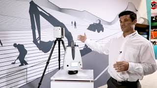
9.6.1 Mobile Laser Scanning (MLS)
- Definition and Functionality: MLS systems are mounted on vehicles or carried in backpacks, making them highly versatile for corridor mapping, including roads and railways.
9.6.2 UAV-based Laser Scanning
- Technology Sync: This method combines Airborne Laser Scanning with drone technology, offering a cost-effective solution for small and medium projects, which enhances accessibility and fieldwork efficiency.
9.6.3 Integration with Other Technologies
- Photogrammetry: This is used to colorize point clouds for better visualization.
- SLAM (Simultaneous Localization and Mapping): Supports real-time navigation and mapping, eliminating the need for GPS, which is beneficial in challenging environments.
- AI/ML Automation: Incorporates artificial intelligence and machine learning for automated classification and object detection, significantly reducing manual processing efforts.
9.6.4 Real-time Data Acquisition and Visualization
- Adaptive Techniques: On-site quality checks and live 3D modeling capabilities are now being utilized, enabling applications in augmented reality (AR) and virtual reality (VR) for infrastructure visualization and user engagement.
Youtube Videos


Audio Book
Dive deep into the subject with an immersive audiobook experience.
Mobile Laser Scanning (MLS)
Chapter 1 of 4
🔒 Unlock Audio Chapter
Sign up and enroll to access the full audio experience
Chapter Content
• Mounted on vehicles or backpacks.
• Ideal for corridor mapping (roads, railways).
Detailed Explanation
Mobile Laser Scanning (MLS) is a technology where laser scanners are attached to moving vehicles or even carried by people on their backs. This setup allows for efficient data collection in various environments. The primary benefit is its suitability for corridor mapping, such as along roads and railways, where long and narrow areas need to be scanned quickly and efficiently.
Examples & Analogies
Imagine a street artist walking down a busy road, using a special camera that captures a detailed 3D map of everything around them. Just like capturing scenes for a painting, MLS captures data about the environment as it moves, making it perfect for documenting infrastructure like highways and train tracks.
UAV-based Laser Scanning
Chapter 2 of 4
🔒 Unlock Audio Chapter
Sign up and enroll to access the full audio experience
Chapter Content
• Combines ALS with drone technology.
• Cost-effective for small and medium projects.
Detailed Explanation
UAV-based Laser Scanning refers to the use of drones equipped with laser scanning technology, essentially combining the principles of Airborne Laser Scanning (ALS) with modern drones. This approach significantly reduces costs and time for small to medium-sized projects. Drones can easily access areas that might be hard to reach by traditional aircraft, providing precise elevation and surface data.
Examples & Analogies
Think of a drone as a superhero that can fly over tough terrains like forests or dense city areas where a helicopter might struggle. By using UAVs, engineers can survey land for new developments, analyze environmental impacts, or map areas for conservation without the expense of using larger aircraft.
Integration with Other Technologies
Chapter 3 of 4
🔒 Unlock Audio Chapter
Sign up and enroll to access the full audio experience
Chapter Content
• Photogrammetry: For colorizing point clouds.
• SLAM (Simultaneous Localization and Mapping): Real-time navigation and mapping without GPS.
• AI/ML for Automation: Automated classification and object detection.
Detailed Explanation
This chunk highlights how laser scanning is not a standalone technology; it works best when integrated with other modern techniques. For instance, photogrammetry can enhance scanned data by adding colors to the point clouds, making visual analysis easier. Simultaneous Localization and Mapping (SLAM) allows devices to navigate and map environments accurately without requiring GPS, which is essential in complex or indoor settings. Additionally, advancements in Artificial Intelligence (AI) and Machine Learning (ML) are automating processes related to data classification and object detection, making the overall interpretation of laser data quicker and more efficient.
Examples & Analogies
Imagine combining a painter's color palette with a sculptor's clay model. Just as the painter enhances the 3D form with color, technologies like photogrammetry add detail to laser scans. Meanwhile, think of AI as a smart assistant helping a librarian sort and catalog books more quickly. This integration makes working with laser data not just easier but also smarter.
Real-time Data Acquisition and Visualization
Chapter 4 of 4
🔒 Unlock Audio Chapter
Sign up and enroll to access the full audio experience
Chapter Content
• On-site quality checks and live 3D modeling.
• AR/VR applications for infrastructure visualization.
Detailed Explanation
Real-time data acquisition means that as data is collected through laser scanning, it can be immediately visualized in 3D. This instantaneous feedback allows professionals to conduct quality checks on-site, ensuring data accuracy and reliability. The use of Augmented Reality (AR) and Virtual Reality (VR) technologies enables the overlay of this data onto physical spaces, allowing stakeholders to visualize infrastructure developments in an immersive and interactive manner.
Examples & Analogies
Picture wearing goggles that let you see a new building design superimposed right where it will be built! Just like how a video game can offer a first-person experience of a fictional world, AR and VR can bring laser data to life, enabling engineers and planners to evaluate designs before construction starts.
Key Concepts
-
Mobile Laser Scanning (MLS): A portable laser scanning technology for corridor mapping.
-
UAV-based Laser Scanning: Integration of drones with laser scanning for enhanced data acquisition.
-
Photogrammetry: Technology used for enriching point cloud data with colors.
-
SLAM: A method allowing real-time mapping without GPS.
-
AI/ML Automation: Use of artificial intelligence for automating data processing tasks.
-
Real-time Visualization: Immediate access to data models and quality checks through AR and VR.
Examples & Applications
An example of MLS is scanning a highway while driving to capture its features efficiently.
Using UAV-based scanning to monitor construction sites periodically can save costs and improve oversight.
Memory Aids
Interactive tools to help you remember key concepts
Rhymes
UAVs in the sky, mapping near and far,
Stories
Imagine a drone squad going over valleys and hills, mapping out terrains that are hard to fill. With laser beams shining down, they gather data to crown, and by using AI, they're never out of town.
Memory Tools
Remember 'U-M-P-S': UAVs, Mobile scanning, Photogrammetry, SLAM – all vital for modern land data examining.
Acronyms
Think 'MUST' for MLS, UAVs, SLAM, and Technology – the four keys to future spatial geography.
Flash Cards
Glossary
- Mobile Laser Scanning (MLS)
A laser scanning technology mounted on vehicles or backpacks for efficient data capture in corridor mapping.
- UAVbased Laser Scanning
The application of drone technology combined with airborne laser scanning for cost-effective surveying.
- Photogrammetry
The use of photography to measure and obtain reliable information about physical objects for colorizing point clouds.
- SLAM (Simultaneous Localization and Mapping)
A technology that enables real-time mapping and navigation without GPS.
- AI/ML (Artificial Intelligence/Machine Learning)
Technologies used to automate data processing tasks such as object detection and classification.
- AR (Augmented Reality)
A technology that overlays digital information onto the physical world to enhance user experience.
- VR (Virtual Reality)
An immersive technology that simulates complete environments through computer-generated scenarios.
Reference links
Supplementary resources to enhance your learning experience.