
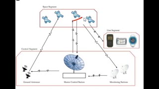
Components of GNSS
Enroll to start learning
You’ve not yet enrolled in this course. Please enroll for free to listen to audio lessons, classroom podcasts and take practice test.
Interactive Audio Lesson
Listen to a student-teacher conversation explaining the topic in a relatable way.
Space Segment of GNSS
🔒 Unlock Audio Lesson
Sign up and enroll to listen to this audio lesson

Today we're discussing the Space Segment of GNSS, which includes satellites in medium Earth orbit. How many satellites do you think make up a GNSS constellation?

I think there are about 20 satellites.
Close! There are typically 24 to 30 satellites. These satellites continuously transmit signals carrying time and orbital data. This enables accurate positioning on Earth regardless of weather conditions. Can anyone tell me why this is important?

It's important for navigation, like finding directions or mapping.
Exactly! GPS is widely used for navigation. Let’s remember this with the acronym S.A.T., which stands for Satellite, Accuracy, Timing. What does each word signify?

S for Satellites, A for Accuracy in positioning, and T for Timing data they transmit!
Great job! So always remember S.A.T. when thinking about the Space Segment.
Control Segment of GNSS
🔒 Unlock Audio Lesson
Sign up and enroll to listen to this audio lesson

Now let's talk about the Control Segment of GNSS. What do you think happens at ground stations?

They probably monitor the satellites?
That’s correct! The ground stations ensure the satellite's health, managed from the Master Control Station. These stations also synchronize satellite data. Why might synchronization be crucial?
Because the timing has to be precise for accurate location measurements!
Exactly! Synchronization is vital. Remember the phrase ‘Control is Key’ to think about the importance of this segment!
User Segment of GNSS
🔒 Unlock Audio Lesson
Sign up and enroll to listen to this audio lesson
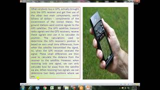
Lastly, let’s cover the User Segment. Who can tell me what kind of devices use GNSS receivers?
Smartphones and GPS devices, right?
Correct! GNSS receivers determine positioning by triangulating signals from at least four satellites. Can anyone explain why we need at least four satellites?
To accurately calculate a 3D position and account for timing!
Exactly! And remember the term T.T.T. - Triangle, Timing, Transformation. This will help you recall the user segment!
Introduction & Overview
Read summaries of the section's main ideas at different levels of detail.
Quick Overview
Standard
The Components of GNSS are categorized into three segments. The space segment consists of satellites in medium Earth orbit that transmit signals. The control segment maintains satellite health and orbits through ground stations, while the user segment consists of GNSS receivers that calculate positions using signals from multiple satellites.
Detailed
Components of GNSS
The Global Navigation Satellite System (GNSS) is essential for precise positioning and is composed of three critical segments:
1. Space Segment
- This segment features a constellation of satellites orbiting Earth, typically comprising 24-30 satellites in medium Earth orbit (MEO). They continuously send signals that carry essential time and orbital data, allowing users to calculate their positions on Earth.
2. Control Segment
- Ground stations monitor and manage the satellite system. This segment includes the Master Control Station and various monitoring stations globally. Its responsibilities include maintaining satellite health, controlling orbits, and ensuring synchronization and integrity of satellite data.
3. User Segment
- Consists of the GNSS receivers used by individuals and devices to determine their precise locations. To calculate their position, these receivers need to triangulate signals from at least four satellites, employing either single-frequency or dual-frequency receivers based on the required accuracy.
Together, these segments work seamlessly to provide users with accurate positioning and timing information worldwide, playing a vital role in various applications, especially in civil engineering.
Youtube Videos


Audio Book
Dive deep into the subject with an immersive audiobook experience.
Space Segment
Chapter 1 of 3
🔒 Unlock Audio Chapter
Sign up and enroll to access the full audio experience
Chapter Content
• Consists of satellites orbiting Earth.
• Typically includes 24–30 satellites in medium Earth orbit (MEO) per constellation.
• Satellites continuously transmit signals containing time and orbital data.
Detailed Explanation
The Space Segment is an essential part of GNSS that includes the satellites orbiting the Earth. These satellites work together to provide global coverage. Usually, each GNSS constellation has about 24 to 30 satellites, commonly positioned in Medium Earth Orbit (MEO). This setup allows them to continuously transmit important signals that contain information about the satellite's position and the timing of the signals, which are critical for accurate positioning calculations by GNSS receivers.
Examples & Analogies
Think of the Space Segment as a group of tall trees in a forest (the satellites) that provide shade (the signals) to people walking below (the GNSS receivers). Just as people rely on the trees for comfort and protection from the sun, GNSS receivers depend on these satellites to obtain their necessary data for accurate positioning.
Control Segment
Chapter 2 of 3
🔒 Unlock Audio Chapter
Sign up and enroll to access the full audio experience
Chapter Content
• Ground stations that monitor, control, and manage satellite health and orbits.
• Includes Master Control Station and monitoring stations spread globally.
• Responsible for synchronization and integrity of satellite data.
Detailed Explanation
The Control Segment is made up of ground stations that are crucial for monitoring and managing the satellites in orbit. These stations check the health status of each satellite, ensuring they are functioning correctly. The Master Control Station, along with various monitoring stations around the world, ensures the satellites are correctly synchronized and that the data they send to GNSS receivers is accurate and reliable. This segment acts like the command center for the entire GNSS system.
Examples & Analogies
Imagine a dashboard in a spaceship that pilots use to monitor the ship's systems and ensure everything is operating smoothly. The Control Segment functions similarly, constantly checking on all the satellites to make sure they are safe and sending out constant, usable data.
User Segment
Chapter 3 of 3
🔒 Unlock Audio Chapter
Sign up and enroll to access the full audio experience
Chapter Content
• Consists of GNSS receivers used by individuals or devices.
• These receivers calculate position by triangulating signals from at least four satellites.
• Can be single-frequency or dual-frequency receivers depending on accuracy needs.
Detailed Explanation
The User Segment refers to the GNSS receivers that individuals or devices use to determine their location. These receivers work by triangulating signals from a minimum of four satellites. By measuring how long it takes for signals from these satellites to reach them, the receivers can calculate their exact position. Users may choose between single-frequency receivers, which are simpler and cheaper, or dual-frequency receivers, which provide greater accuracy by reducing errors caused by atmospheric conditions.
Examples & Analogies
Think of GNSS receivers as a group of friends using their mobile phones to find their way to a restaurant. Each phone acts like a receiver that listens to location data from satellites, similar to how friends might check in with each other to ensure they all arrive at the same place using different routes. The more friends (satellites) they connect with, the better they navigate to their desired destination.
Key Concepts
-
Space Segment: The satellites that transmit signals.
-
Control Segment: Ground stations monitoring satellite data.
-
User Segment: Devices that calculate positions using satellite signals.
Examples & Applications
Example of Space Segment: GPS satellites orbiting Earth provide location services to receivers.
Example of Control Segment: A Master Control Station ensures satellites are functioning and accurately positioned.
Example of User Segment: Smartphones use GNSS receivers for navigation and location tracking services.
Memory Aids
Interactive tools to help you remember key concepts
Rhymes
The satellites high in space, provide us a location place.
Stories
Imagine a team of satellites floating in the sky, sending signals down to help you know exactly where you are!
Memory Tools
Remember S.C.U. for Space, Control, and User - the three segments of GNSS.
Acronyms
Use C.S.U. for Control (ground), Space (satellites), and User (receivers).
Flash Cards
Glossary
- GNSS
Global Navigation Satellite System, a system comprising multiple satellite systems that provide positioning and timing data.
- Space Segment
The satellites in orbit that provide signals necessary for positioning.
- Control Segment
Ground stations that monitor the health and orbit of satellites.
- User Segment
The devices, like GNSS receivers, used to interpret signals from satellites for location determination.
Reference links
Supplementary resources to enhance your learning experience.