
Sources of GNSS Errors
Enroll to start learning
You’ve not yet enrolled in this course. Please enroll for free to listen to audio lessons, classroom podcasts and take practice test.
Interactive Audio Lesson
Listen to a student-teacher conversation explaining the topic in a relatable way.
Introduction to GNSS Errors
🔒 Unlock Audio Lesson
Sign up and enroll to listen to this audio lesson

Today, we’re going to discuss the various sources of GNSS errors. Does anyone know what GNSS stands for?

Is it Global Navigation Satellite System?
Correct! Now, one of the first sources of errors relates to the clocks onboard the satellites. Can anyone tell me what happens with satellite clock errors?

I think if the satellite clocks are not perfectly accurate, it can cause timing errors and affect positioning.
Exactly! These timing errors can lead to significant position errors. Remember the acronym 'CT' for Clock Timing errors. Now, let’s explore another source.
Atmospheric Delays
🔒 Unlock Audio Lesson
Sign up and enroll to listen to this audio lesson

So, atmospheric conditions can affect GNSS accuracy. What are the two main atmospheric layers we should be aware of?

The ionosphere and the troposphere?
Great! These layers can slow down the signals, causing delays. Let’s remember the acronym 'ITD' for Ionospheric and Tropospheric Delays. Can someone explain why these delays matter?

Delays matter because they can change the time it takes for signals to reach the receiver, leading to inaccurate position calculations.
Exactly! We need to account for these delays when processing GNSS data.
Multipath Effects
🔒 Unlock Audio Lesson
Sign up and enroll to listen to this audio lesson
Let’s move on to multipath effects. Who can describe what multipath errors are?
They occur when GNSS signals reflect off surfaces before reaching the receiver.
Exactly! This reflection can distort the signal's path and duration. Remember 'RWS' for Reflected Wave Signals. Why might this be an issue in urban areas?
Because there are lots of buildings that can reflect the signals.
Correct! Urban environments can severely impact the accuracy of GNSS due to multipath effects.
Receiver Noise and Orbital Errors
🔒 Unlock Audio Lesson
Sign up and enroll to listen to this audio lesson
Now let's talk about internal errors. What can cause receiver noise?
The electronic components in the GNSS receiver themselves can create noise.
Exactly! This noise can distort the measurements. Remember NP for Noise in the Receiver. Now let’s touch on orbital errors, who wants to explain?
Orbital errors happen when the data about the satellite's preset orbit has inaccuracies.
Right! Incorrect ephemeris data leads to positional errors. We can remember 'OD' for Orbital Data errors.
Geometry of Satellite Constellation
🔒 Unlock Audio Lesson
Sign up and enroll to listen to this audio lesson
Finally, let's discuss the geometry of the satellite constellation. Why is the arrangement of satellites important?
Because if satellites are too close together, it increases Dilution of Precision.
Correct! Poor geometry means less accurate positioning. Remember 'DP' for Dilution of Precision. What can we do to mitigate this?
We should ensure we have a good spread of satellites in the sky when taking measurements.
Exactly! A good satellite geometry is essential for improving GNSS accuracy. Let’s summarize: remember CT for clock errors, ITD for atmospheric delays, RWS for multipath effects, NP for receiver noise, OD for orbital errors, and DP for geometry.
Introduction & Overview
Read summaries of the section's main ideas at different levels of detail.
Quick Overview
Standard
Several sources contribute to GNSS errors, including satellite clock discrepancies, atmospheric effects, multipath influences, internal receiver noise, orbital inaccuracies, and the geometry of satellite positioning. Understanding these errors is vital for improving GNSS performance in surveying applications.
Detailed
Sources of GNSS Errors
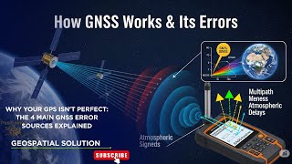
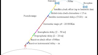
GNSS (Global Navigation Satellite System) provides critical positioning data for various applications, but its accuracy can be compromised by multiple sources of error. Key sources include:
- Satellite Clock Errors: Variances in satellite clock precision cause time-related inaccuracies, leading to positional errors. Even minor time discrepancies can distort the computed position significantly.
- Ionospheric and Tropospheric Delays: The signals transmitted by satellites travel through different atmospheric layers, which can slow them down. Such delays are more pronounced in the ionosphere and troposphere, introducing further inaccuracies in position calculations.
- Multipath Effects: When GNSS signals reflect off surfaces like buildings or water bodies before reaching the receiver, it causes signal delays that result in distorted position calculations. This phenomenon is particularly relevant in urban environments.
- Receiver Noise: The receiver itself can contribute to inaccuracies through internal electronic noise, which may distort incoming signals and lead to incorrect readings.
- Orbital Errors: Imperfections in satellite ephemeris data—information about a satellite's position and movement—can lead to inaccuracies in computing the receiver's position.
- Geometry of Satellite Constellation: The spatial arrangement of satellites affects accuracy; poor geometry, where satellites are clustered together, can increase the Dilution of Precision (DOP), hence degrading accuracy.
Understanding these error sources is crucial for surveyors and engineers to ensure the reliability of GNSS measurements in various applications.
Youtube Videos


Audio Book
Dive deep into the subject with an immersive audiobook experience.
Satellite Clock Errors
Chapter 1 of 6
🔒 Unlock Audio Chapter
Sign up and enroll to access the full audio experience
Chapter Content
• Imperfect satellite clocks cause small time errors, leading to position errors.
Detailed Explanation
Satellite clocks are critical for GNSS accuracy. If a satellite's clock is not perfectly synchronized, it can show that a signal was sent at a different time than it actually was. This causes the GNSS receiver to miscalculate the distance to that satellite, which, in turn, affects the overall position accuracy. Even a small error in time can result in significant positioning inaccuracies on the ground.
Examples & Analogies
Imagine a runner timing themselves with a stopwatch that is running 5 seconds late. Even if the runner runs a perfect lap, the stopwatch will show a time that is 5 seconds longer than the actual time. Similarly, if a satellite’s clock is slow or fast, the position calculated will not be accurate.
Ionospheric and Tropospheric Delays
Chapter 2 of 6
🔒 Unlock Audio Chapter
Sign up and enroll to access the full audio experience
Chapter Content
• Signals slow down in atmospheric layers, introducing delays.
Detailed Explanation
GNSS signals pass through different layers of the atmosphere—primarily the ionosphere and the troposphere. The ionosphere, which is charged particles in the upper atmosphere, can cause delays due to variations in electron density. Similarly, the troposphere, which consists of water vapor and other gases, can also slow down signals. As a result, when signals are delayed, the GNSS receiver can misinterpret the time it took for the signal to arrive, leading to inaccuracies in positioning.
Examples & Analogies
Consider how your voice sounds different when you speak underwater versus on land. Water and air both slow down sound waves but in different ways, leading to distortions. Likewise, the atmosphere affects GNSS signals, causing them to take longer to reach their destination.
Multipath Effects
Chapter 3 of 6
🔒 Unlock Audio Chapter
Sign up and enroll to access the full audio experience
Chapter Content
• Signal reflections from surfaces like buildings or water bodies create errors.
Detailed Explanation
Multipath effects occur when signals bounce off surfaces before they reach the receiver. For example, if a signal reflects off a large building or a body of water, it can arrive at the receiver later than expected. This can result in calculating an incorrect position since the receiver may think the signal came directly from the satellite without accounting for the reflection delay.
Examples & Analogies
Think of an echo in a canyon: when you shout, the sound reflects off the canyon walls and reaches your ears later than the direct sound. Similarly, if GNSS signals bounce off tall buildings, this reflection can lead to erroneous positioning.
Receiver Noise
Chapter 4 of 6
🔒 Unlock Audio Chapter
Sign up and enroll to access the full audio experience
Chapter Content
• Internal noise from the receiver’s electronics can distort measurements.
Detailed Explanation
GNSS receivers convert signals into usable data. Internal electronics can introduce noise—a sort of random variability in measurements—that distorts the accuracy of the signals received from satellites. This noise can stem from various factors, like temperature variations or electronic interference, leading to less reliable positioning.
Examples & Analogies
Imagine trying to listen to a radio station with static noise. You may hear the music, but the static distorts the sound, making it hard to understand the lyrics. Similarly, noise in GNSS receivers can obscure the accurate signals they receive, making the positions less reliable.
Orbital Errors
Chapter 5 of 6
🔒 Unlock Audio Chapter
Sign up and enroll to access the full audio experience
Chapter Content
• Imperfect satellite ephemeris data leads to inaccuracies.
Detailed Explanation
Ephemeris data provides information about a satellite's orbit. If this data is inaccurate or outdated, the GNSS receiver may calculate positions incorrectly. Since the satellites are constantly moving, even small inaccuracies in their predicted location can lead to significant positioning errors on Earth.
Examples & Analogies
Think of it as trying to hit a target with a bow and arrow while being given inaccurate wind signals. If you aim based on past wind patterns that are no longer relevant, your arrow might miss the target entirely. Similarly, outdated orbital information can lead to inaccurate GNSS results.
Geometry of Satellite Constellation
Chapter 6 of 6
🔒 Unlock Audio Chapter
Sign up and enroll to access the full audio experience
Chapter Content
• Poor geometry (satellites clustered together) increases Dilution of Precision (DOP).
Detailed Explanation
The arrangement of satellites overhead affects positioning accuracy—a concept known as the geometry of the satellite constellation. If satellites are too close together in the sky, the receiver may struggle to pinpoint an exact location, leading to high Dilution of Precision (DOP). Ideally, satellites should be well-distributed for maximum accuracy.
Examples & Analogies
Imagine trying to pinpoint your location in a city where you can only see a few close buildings. This might not allow you to determine your exact position in relation to the entire city. However, if you can see buildings spread across the skyline, you can estimate your location more accurately. Similarly, a well-distributed satellite geometry helps sharpen GNSS accuracy.
Key Concepts
-
Satellite Clock Errors: Timing discrepancies in satellite signals.
-
Ionospheric and Tropospheric Delays: Atmospheric conditions impacting signal travel time.
-
Multipath Effects: Reflections of signals causing inaccuracies.
-
Receiver Noise: Internal distortions from the receiver's electronics.
-
Orbital Errors: Inaccurate satellite position data.
-
Geometry of Satellite Constellation: Arrangement of satellites affecting measurement precision.
Examples & Applications
An example of satellite clock errors could be a satellite that runs 1 millisecond fast, leading to a positional error of several meters.
In an urban environment, signals from buildings reflecting could cause a receiver to miscalculate its position by up to 10 meters.
Memory Aids
Interactive tools to help you remember key concepts
Rhymes
Clock errors are snappy, they make timing flaky, so watch your position, or it will get shaky!
Stories
Imagine a sailor trying to navigate his ship but ran into a foggy sea with many islands. He relies on GNSS signals, but the reflections off the water cause him to misjudge his position, illustrating multipath effects.
Memory Tools
Remember 'CIMOR' for the key sources of GNSS errors: Clock errors, Ionospheric delays, Multipath effects, Orbital errors, and Receiver noise.
Acronyms
DP for Dilution of Precision reminds us that satellite geometry impacts how accurately we pinpoint our position.
Flash Cards
Glossary
- Satellite Clock Errors
Timing inaccuracies in satellite signals that lead to positional errors.
- Ionospheric and Tropospheric Delays
Delays in GNSS signals due to atmospheric conditions that slow down signal transmission.
- Multipath Effects
Errors caused by GNSS signals reflecting off surfaces before reaching the receiver.
- Receiver Noise
Internal electronic noise from the GNSS receiver that can distort measurements.
- Orbital Errors
Inaccuracies in satellite orbital data that affect positioning.
- Dilution of Precision (DOP)
A measure of the geometrical arrangement of satellites that impacts positioning accuracy.
Reference links
Supplementary resources to enhance your learning experience.