
GNSS Signals and Frequencies
Enroll to start learning
You’ve not yet enrolled in this course. Please enroll for free to listen to audio lessons, classroom podcasts and take practice test.
Interactive Audio Lesson
Listen to a student-teacher conversation explaining the topic in a relatable way.
Overview of GNSS Frequencies
🔒 Unlock Audio Lesson
Sign up and enroll to listen to this audio lesson

Today, we're discussing the various frequencies that GNSS satellites transmit. Why do you think multiple frequencies are necessary for GNSS?

Maybe to improve accuracy?
Absolutely! Different frequencies help in mitigating errors due to atmospheric conditions. For instance, GPS uses L1, L2, and L5. Can anyone remember what L1's frequency is?

L1 is 1575.42 MHz!
Correct! Remember this: when you're in a challenging environment, dual-frequency receivers can provide better results. That's because they can consider errors on both L1 and L2.

So if one signal is disrupted, the other can still work?
Exactly! That redundancy is crucial for reliable positioning.
To recap, GNSS uses multiple frequencies for enhanced accuracy and reliability. GPS's L1 and L2 frequencies play a vital role in this.
Data carried by GNSS Signals
🔒 Unlock Audio Lesson
Sign up and enroll to listen to this audio lesson

Now, let’s dive into what information these frequencies actually transmit. Can anyone tell me what a navigation message includes?

It includes the satellite's position and clock data?
That's correct! Plus, it provides health information about the satellite. This is essential for knowing if the satellite is functioning correctly. Let's also discuss ephemeris data. What does this data provide?
The precise orbit details of the satellite?
Exactly! This information is crucial for accurate positioning. Each satellite can be thought of as a puzzle piece in the larger map of the Earth. Without knowing their orbits, the picture remains incomplete.
And almanac data?
Great question! Almanac data contains information about the status and orbit of all satellites in the constellation. It helps receivers to quickly locate satellites.
In summary, GNSS signals carry navigation messages, ephemeris data, and almanac data, which are crucial for providing reliable positioning information.
Differences between GNSS Systems
🔒 Unlock Audio Lesson
Sign up and enroll to listen to this audio lesson
Next, let’s look at the different GNSS systems and their frequencies. Why do you think it’s important to have multiple systems like GPS, GLONASS, and Galileo?
Because they increase coverage and reliability?
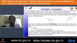
Exactly! Having receivers capable of accessing multiple systems ensures better positional accuracy and reduces the likelihood of signal loss. For example, GLONASS operates with L1 and L2 frequencies but uses different frequency ranges. Can anyone tell me the frequencies for GLONASS?
L1 is around 1602 MHz and L2 is 1246 MHz.
Perfect! Galileo uses E1, E5a, E5b, and E6. The differences among these systems allow for unique applications. It’s fascinating how this technology improves our ability to navigate!
To wrap up, understanding the unique frequencies assigned to each GNSS system helps us appreciate their specific advantages in various applications.
Introduction & Overview
Read summaries of the section's main ideas at different levels of detail.
Quick Overview
Standard
GNSS satellites transmit signals on multiple frequencies that convey critical data including satellite positioning and health information. Each system, such as GPS and GLONASS, has designated frequencies that enhance signal reliability and accuracy.
Detailed
GNSS Signals and Frequencies
In the operation of the Global Navigation Satellite Systems (GNSS), each satellite transmits signals across multiple frequencies to support accurate positioning and navigation. The key frequencies include:
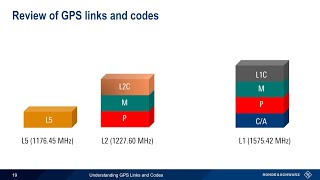
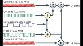
- GPS: L1 (1575.42 MHz), L2 (1227.60 MHz), L5 (1176.45 MHz)
- GLONASS: L1 (1602 MHz + frequency offset), L2 (1246 MHz)
- Galileo: E1, E5a, E5b, E6
- BeiDou: B1, B2, B3
These frequencies are essential as they carry various crucial data:
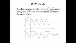
- Navigation message: Contains information on the satellite's position, clock data, and health information.
- Ephemeris data: Provides the precise orbit details of the satellite.
- Almanac data: Offers status updates and orbit information for all satellites within the constellation.
Understanding these signals and frequencies is significant for GNSS applications in surveying, mapping, and navigation, as they ensure the reliability of the signals received.
Youtube Videos


Audio Book
Dive deep into the subject with an immersive audiobook experience.
Frequency Bands of GNSS Satellites
Chapter 1 of 2
🔒 Unlock Audio Chapter
Sign up and enroll to access the full audio experience
Chapter Content
Each GNSS satellite transmits signals on multiple frequencies:
• GPS: L1 (1575.42 MHz), L2 (1227.60 MHz), L5 (1176.45 MHz)
• GLONASS: L1 (1602 MHz + freq. offset), L2 (1246 MHz)
• Galileo: E1, E5a, E5b, E6
• BeiDou: B1, B2, B3
Detailed Explanation
GNSS satellites transmit signals on different frequencies. Each satellite system has its own unique set of frequencies, known as frequency bands. For example, the GPS system uses three primary frequencies: L1, L2, and L5, which operate at different megahertz (MHz) values. The GLONASS system also has its frequencies, including L1 and L2 but with specific offsets. Galileo and BeiDou, the European and Chinese GNSS systems respectively, have their own designated frequencies as well. This diversity allows for various techniques in GNSS technology that can achieve better accuracy and reliability in positioning.
Examples & Analogies
Think of each frequency as a different radio station. Just like you may tune into different stations to catch different songs or programs, GNSS receivers can pick and choose which frequency to listen to for clearer and more accurate positioning data.
Content of GNSS Signals
Chapter 2 of 2
🔒 Unlock Audio Chapter
Sign up and enroll to access the full audio experience
Chapter Content
These signals carry:
• Navigation message: Satellite position, clock data, health info.
• Ephemeris data: Precise orbit of the satellite.
• Almanac data: Status and orbit of all satellites in constellation.
Detailed Explanation
Each GNSS signal contains valuable information that aids in accurate positioning. The navigation message informs the receiver about the satellite's current position, the time, and condition of the satellite (health info). Ephemeris data provides precise details about the satellite's orbit, allowing for accurate calculations of position. Almanac data gives a broader overview regarding the general status and orbits of all satellites in the constellation. Together, this data ensures that GNSS receivers can accurately determine their location by selecting and interpreting signals from multiple satellites.
Examples & Analogies
Imagine you're trying to find a particular store in a large shopping mall. The navigation message is like the mall directory that points you to the right store. The ephemeris data is akin to a detailed map of that specific store's layout, and the almanac data provides you with an overview of all the stores in the mall, helping you understand the general position of different stores as you walk around.
Key Concepts
-
Multiple Frequencies: Different GNSS systems operate on various frequencies that improve signal accuracy and reliability.
-
Navigation Message: A crucial component of GNSS signals that carries data about satellite positioning, time, and health.
-
Ephemeris and Almanac Data: Essential datasets for accurate positioning, providing satellite orbits and constellation information.
Examples & Applications
GPS satellites transmit signals at L1 (1575.42 MHz), L2 (1227.60 MHz), and L5 (1176.45 MHz), providing redundancy and accuracy.
Galileo’s unique frequencies (E1, E5a, E5b, E6) allow seamless interoperability with other GNSS systems.
Memory Aids
Interactive tools to help you remember key concepts
Rhymes
Three frequencies for GPS, L1, L2, and L5 are best!
Stories
Imagine a race between satellites; L1 leads, L2 follows, and L5 boosts through the clouds, ensuring they always find their way safely!
Memory Tools
To remember GPS frequencies: 'L1 is life, L2 is clear, L5 boosts the steer!'
Acronyms
Remember 'EAG' for Galileo frequencies
E1
E5a
E5b
E6.
Flash Cards
Glossary
- GNSS
Global Navigation Satellite System; a constellation of satellites that provide positional and timing information.
- Frequency
The specific radio wave signal on which a satellite transmits data.
- Navigation Message
Information relayed by a satellite containing data about its position, clock information, and health status.
- Ephemeris Data
Data providing the precise orbit of a satellite necessary for accurate positioning.
- Almanac Data
Information about the status and orbit of all satellites in the constellation.
Reference links
Supplementary resources to enhance your learning experience.