
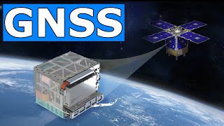
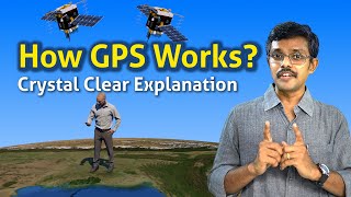
Working Principle of GNSS
Enroll to start learning
You’ve not yet enrolled in this course. Please enroll for free to listen to audio lessons, classroom podcasts and take practice test.
Interactive Audio Lesson
Listen to a student-teacher conversation explaining the topic in a relatable way.
Introduction to GNSS Positioning
🔒 Unlock Audio Lesson
Sign up and enroll to listen to this audio lesson

Today, we are going to learn about the working principle of GNSS. GNSS stands for Global Navigation Satellite System, and it helps us find our position on Earth. The key concept here is something called trilateration. Can anyone explain what trilateration means?

Is it like triangulating your position using distances from points?
Exactly! In GNSS, we use distances from satellites to figure out where we are. So, how does the receiver know the distance to a satellite?

It calculates how long the signal took to arrive!
That's correct! We multiply that time by the speed of light to determine the distance. We need signals from at least four satellites to find our 3D position: longitude, latitude, and height. Let’s remember this with the acronym 'P-4'—P for Position and 4 for the four satellites needed!

So, P-4 like Position from 4 satellites?
Great! Now, what could happen if we only had three satellites?

We wouldn’t be able to get the height, right?
Exactly! To summarize, trilateration needs at least four satellites for accurate positioning. Great job, everyone!
Measuring Distances with Signals
🔒 Unlock Audio Lesson
Sign up and enroll to listen to this audio lesson

Now that we understand trilateration, let's dive a bit deeper into how distances are actually measured. The first method is called the pseudorange. Who can tell me what that involves?
It's the approximate distance to the satellite based on signal timing!
Exactly! But there’s also a more accurate method. Does anyone remember what that’s called?
Carrier phase, right?
Yes! The carrier phase method allows us to achieve much higher accuracy by using the actual phase of the carrier wave. Why do you think this is more accurate?
Maybe it helps reduce the timing errors?
Correct! It's all about refining the measurements. Let’s use a mnemonic, 'C-P-S'—C for Carrier phase, P for Precision, and S for Signals. This will help you remember that carrier phase increases the precision of our location calculations!
So, C-P-S reminds us of carrier phase's role in increasing precision!
Precisely! To sum it up, distance to satellites can be measured using pseudorange and carrier phase, with the latter providing more precision. Great work, team!
Review of GNSS Positioning Principles
🔒 Unlock Audio Lesson
Sign up and enroll to listen to this audio lesson
Let’s review what we’ve learned about GNSS positioning! What is the first step in determining our location using GNSS?
The satellite sends a signal that contains data!
Correct! What's the next step then?
The receiver calculates how long it took to get that signal!
Right! And from that timing information, how do we find the distance to the satellite?
By multiplying the signal travel time by the speed of light!
Exactly! Just remember 'P-4' for the four satellites for positioning. Now, what are the two methods to measure distance?
Pseudorange and carrier phase!
Correct! And which one is more accurate?
The carrier phase method!
Perfect. So, in summary, GNSS positioning involves signals from satellites, timing calculations, and methods like pseudorange and carrier phase. Well done, everyone!
Introduction & Overview
Read summaries of the section's main ideas at different levels of detail.
Quick Overview
Standard
GNSS operates on the principle of trilateration, requiring signals from at least four satellites to calculate a receiver's three-dimensional position and clock offset. Utilizing both pseudorange and carrier phase enhances the precision of positioning.
Detailed
Working Principle of GNSS
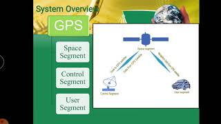
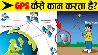
GNSS (Global Navigation Satellite System) positioning is fundamentally based on trilateration, a geometric method to determine the position of a point on Earth's surface by measuring its distances from multiple known points—in this case, satellites. The process involves the following key steps:
- A satellite transmits a signal that includes time and orbital data.
- The GNSS receiver calculates the time it took for this signal to reach it.
- By multiplying the signal travel time by the speed of light, the distance to the satellite is determined.
- Using signals from at least four satellites, the receiver can then compute its 3D position (longitude, latitude, and height) as well as any clock offset that may affect timing.
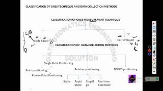
For enhanced precision, GNSS receivers can utilize two methods of distance measurement:
- Pseudorange: This is the approximate distance calculated directly from the signal timing.
- Carrier phase: A more sophisticated technique that determines position based on the phase of the satellite's signal carrier wave, achieving higher accuracy.
Understanding this concept is crucial for applications in surveying, mapping, navigation, and infrastructure development.
Youtube Videos


Audio Book
Dive deep into the subject with an immersive audiobook experience.
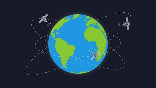
Trilateration Concept
Chapter 1 of 2
🔒 Unlock Audio Chapter
Sign up and enroll to access the full audio experience
Chapter Content
GNSS positioning relies on a concept called trilateration:
1. A satellite transmits a signal with time and orbital data.
2. The GNSS receiver calculates how long it took the signal to arrive.
3. Distance to the satellite = speed of light × signal travel time.
4. With signals from 4+ satellites, the receiver calculates its 3D position and clock offset.
Detailed Explanation
Trilateration is a method used to determine a location based on distances from several reference points. In GNSS, satellites act as reference points. When a satellite transmits a signal, the receiver measures the time it takes for that signal to reach it. Knowing the speed of light, the receiver can then calculate the distance to the satellite. By doing this with at least four satellites, the device can determine its exact position in three dimensions (longitude, latitude, and height) along with correcting any timing errors.
Examples & Analogies
Think of it like trying to find your exact location in a large open field. If you can see one tower in the distance, you might have a general idea of where you are. As more towers come into your view, your understanding becomes clearer. If you can measure how far you are from each tower, you can pinpoint your exact spot in that field.
Pseudorange vs. Carrier Phase
Chapter 2 of 2
🔒 Unlock Audio Chapter
Sign up and enroll to access the full audio experience
Chapter Content
For precise positioning, receivers use:
• Pseudorange: Approximate distance to satellite.
• Carrier phase: More accurate, based on the phase of the signal's carrier wave.
Detailed Explanation
To achieve high precision in positioning, GNSS receivers can use two different methods. The pseudorange provides a rough estimate of how far a satellite is from the receiver by using the time the signal took to travel. However, for more accurate measurements, the carrier phase is used. This method analyzes the actual wave pattern of the signal being received, allowing for more detailed calculations of distance, as it can measure the signal's phase down to fractions of its wavelength.
Examples & Analogies
Imagine you're trying to judge the distance of a thunderstorm. You can count the seconds between seeing the lightning and hearing the thunder to approximate the distance (like pseudorange). However, if you had a high-precision tool to measure the exact vibration of the airwaves from the thunder, you would be able to determine the storm's distance much more accurately (like carrier phase).
Key Concepts
-
GNSS: A system that uses satellites to provide positioning data.
-
Trilateration: The process used to determine a receiver’s location based on signals from satellites.
-
Pseudorange and Carrier Phase: Two methods for measuring distances to satellites.
Examples & Applications
Using GPS to navigate a vehicle involves taking signals from multiple satellites to compute an accurate location for directions.
Mapping points on a construction site can rely on GNSS for laying out structures in precise locations.
Memory Aids
Interactive tools to help you remember key concepts
Rhymes
To find your position, signals you must send, from satellites up high, into the sky they send.
Stories
Imagine a pilot flying with a computer that talks to stars, calculating where they are using satellite signals and the speed of light.
Memory Tools
Remember 'P-4' for Position using 4 satellites.
Acronyms
C-P-S stands for Carrier-phase for Precision in Signals.
Flash Cards
Glossary
- Trilateration
A method for determining the position of a point by measuring distances to it from multiple known points.
- Pseudorange
The approximate distance between a satellite and GNSS receiver based on signal timing.
- Carrier Phase
A more accurate distance measurement based on the phase of the satellite's signal carrier wave.
Reference links
Supplementary resources to enhance your learning experience.