
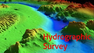
Applications of Hydrographic Surveying
Enroll to start learning
You’ve not yet enrolled in this course. Please enroll for free to listen to audio lessons, classroom podcasts and take practice test.
Interactive Audio Lesson
Listen to a student-teacher conversation explaining the topic in a relatable way.
Safe Navigation
🔒 Unlock Audio Lesson
Sign up and enroll to listen to this audio lesson

Today, we're going to talk about how hydrographic surveying supports safe navigation. Can anyone tell me why nautical charts are important?

I think they help boats know where it's safe to travel?
Exactly! Nautical charts provide crucial information about underwater hazards. This is why hydrographic surveys are regularly conducted to ensure these charts are accurate. Remember, 'CHART' can stand for 'Collecting Hydrographic Assessment for Real-time Travel.'

So, without surveys, the charts would be pretty dangerous, right?
Correct! Unsafe navigation can lead to accidents. What kind of things might surveys identify on these charts?

Underwater rocks or shallow areas?
Yes! Those hazards can cause major issues not just for boats, but for the environment as well. Let’s summarize: hydrographic surveys are critical for safe navigation by identifying navigational hazards.
Dredging and Maintenance
🔒 Unlock Audio Lesson
Sign up and enroll to listen to this audio lesson

Next, let’s dive into dredging. Why do we think dredging is necessary?

To deepen rivers and harbors for bigger ships?
Exactly! Dredging maintains the depth of waterways. Hydrographic surveys assess whether the dredging has been effective. Who can recall how we ensure the right depth?
Using depth measurements from surveys, right?
Correct! Surveys provide ongoing data to help maintain vessel safety. Think of the acronym 'DREDGE' - Dredging Reduces Erosion by Depth Guaranteeing Efficiency.
If we couldn't do these surveys, we might end up with blocked waterways!
Exactly! Dredging without proper surveys can lead to significant navigation issues.
Environmental Impact Assessments
🔒 Unlock Audio Lesson
Sign up and enroll to listen to this audio lesson
Finally, let’s discuss how hydrographic surveys contribute to environmental impact assessments. How might a survey help in protecting marine life?
It shows where sensitive habitats are located, right?
Exactly! By mapping features like reefs or sensitive ecosystems, we can avoid damaging them. Can someone think of an acronym we could use related to this?
'ECO' might work, for 'Evaluating Coastal Operations?'
Great! The goal is to minimize adverse effects on marine environments during construction or other activities. Remember that effective assessments depend heavily on updated data from hydrographic surveys.
So, surveys actually help in preventing environmental degradation?
Absolutely, well summarized! Surveys are one of the ways we can maintain ecological balance while utilizing our marine resources.
Introduction & Overview
Read summaries of the section's main ideas at different levels of detail.
Quick Overview
Standard
The applications of hydrographic surveying encompass crucial areas such as ensuring safe maritime navigation by updating nautical charts, supporting dredging and harbor development, and conducting environmental studies. These applications facilitate effective management of maritime resources and infrastructure.
Detailed
Applications of Hydrographic Surveying
Hydrographic surveying is integral to multiple sectors, significantly impacting how we navigate and utilize our waterways. Here are the key applications:
- Safe Navigation: Hydrographic surveys are essential for generating and updating nautical charts that help mariners navigate safely by identifying underwater hazards and ensuring safe passage.
- Dredging and Maintenance: These surveys inform dredging operations necessary for maintaining navigable waterways, allowing for the safe and efficient movement of vessels.
- Port and Harbor Development: Before constructing ports and harbors, hydrographic surveys assess seabed conditions, which is critical for effective design and operation.
- Coastal Engineering Projects: Hydrographic data aids in designing coastal structures that protect shorelines from erosion and manage sedimentation processes.
- Seabed Cable and Pipeline Laying: Surveys map the seafloor to ensure safe laying of underwater cables and pipelines while avoiding geological obstacles.
- Oil and Gas Exploration: Hydrographic surveys assess site conditions for potential oil and gas extraction, contributing to resource management and environmental protection.
- Coastal Erosion Studies: Monitoring sediment transport and coastal changes help mitigate the impacts of erosion and guide coastal management practices.
- Environmental Impact Assessments: Surveys enable the assessment of marine ecosystems' status, allowing for informed decision-making to protect marine habitats and resources.
Youtube Videos


Audio Book
Dive deep into the subject with an immersive audiobook experience.
Safe Navigation and Nautical Charts
Chapter 1 of 8
🔒 Unlock Audio Chapter
Sign up and enroll to access the full audio experience
Chapter Content
• Safe navigation and updating nautical charts.
Detailed Explanation
Hydrographic surveying is essential for ensuring safe navigation on water bodies. This involves collecting data about the water's depth and the location of hazards such as rocks, shipwrecks, and underwater currents. The gathered data is then used to create and update nautical charts, which are maps specifically designed for marine navigation. These charts help mariners identify safe passage routes and avoid potential dangers.
Examples & Analogies
Imagine you're navigating a new city using a map. If the map has outdated information, you might end up on a road that's been closed or under construction. Just like a city map, nautical charts need to be accurate and current for sailors to navigate safely through waters, avoiding unforeseen obstacles.
Dredging and Maintenance of Waterways
Chapter 2 of 8
🔒 Unlock Audio Chapter
Sign up and enroll to access the full audio experience
Chapter Content
• Dredging and maintenance of waterways.
Detailed Explanation
Hydrographic surveying is utilized to monitor the depth and condition of waterways, which is crucial for dredging activities. Dredging involves removing sediments and debris from the bottom of water bodies to maintain or deepen navigation channels. Regular hydrographic surveys help identify areas that require dredging, ensuring that ships can pass safely without running aground.
Examples & Analogies
Think of it like cleaning a clogged sink. Over time, debris can build up and block water flow. Just as you'd need to clear the blockage to keep water flowing smoothly, hydrographic surveys identify where sediment builds up in rivers and harbors so that dredging can be performed to keep navigation channels clear.
Port and Harbor Development
Chapter 3 of 8
🔒 Unlock Audio Chapter
Sign up and enroll to access the full audio experience
Chapter Content
• Port and harbor development.
Detailed Explanation
Hydrographic surveying plays a vital role in the development of ports and harbors. Before constructing or expanding these facilities, detailed surveys assess the underwater topography, sediment types, and existing infrastructure. This information is critical for engineers and developers to ensure that the designed structures are safe and function effectively, and that they can withstand tidal and wave actions.
Examples & Analogies
Imagine planning a community park. Before starting, you would inspect the land to understand its features—whether it's flat or hilly, or if there are trees to work around. Similarly, before building a port, hydrographic surveys reveal what lies beneath the water so that engineers can design safe and effective facilities.
Coastal Engineering Projects
Chapter 4 of 8
🔒 Unlock Audio Chapter
Sign up and enroll to access the full audio experience
Chapter Content
• Coastal engineering projects.
Detailed Explanation
Hydrographic surveys aid in coastal engineering projects aimed at managing and protecting coastlines. Accurate data about the seabed and surrounding waters is essential for constructing coastal defenses such as seawalls and beach nourishment projects. By understanding the interaction between land and water, engineers can implement solutions to combat erosion and protect coastal communities.
Examples & Analogies
Think of the coastline like a shoreline of a sandcastle on the beach. If the waves are washing away sand from the base, the castle could collapse. Coastal engineering is like reinforcing that sandcastle with rocks or more sand to ensure it stays steady against the waves. Hydrographic surveying helps determine the best way to reinforce those beach defenses.
Seabed Cable and Pipeline Laying
Chapter 5 of 8
🔒 Unlock Audio Chapter
Sign up and enroll to access the full audio experience
Chapter Content
• Seabed cable and pipeline laying.
Detailed Explanation
When laying underwater cables and pipelines, hydrographic surveying is essential to map the seafloor accurately. This information helps engineers identify suitable routes that avoid hazards and ensure stability. The surveys provide data on the seabed conditions, which influence how cables and pipelines are installed to minimize risks and maximize longevity.
Examples & Analogies
Imagine you're laying a long garden hose across your yard. You want to avoid any rocks or obstacles that might pin down the hose or cause kinks. Similarly, before laying cables or pipes underwater, hydrographic surveys help locate a clear path, preventing potential issues during installation.
Oil and Gas Exploration
Chapter 6 of 8
🔒 Unlock Audio Chapter
Sign up and enroll to access the full audio experience
Chapter Content
• Oil and gas exploration.
Detailed Explanation
Hydrographic surveying is crucial in the exploration of oil and natural gas resources beneath the seabed. These surveys help identify potential drilling locations by assessing the geological formations and structure of the ocean floor. Understanding these underwater features is essential for successful exploration and extraction of these energy resources.
Examples & Analogies
Consider a treasure hunt where you need a map to find hidden gold. Just like the map directs you to the treasure, hydrographic surveys guide companies to potential oil and gas deposits, showing where to dig to uncover these valuable resources beneath the ocean.
Coastal Erosion Studies
Chapter 7 of 8
🔒 Unlock Audio Chapter
Sign up and enroll to access the full audio experience
Chapter Content
• Coastal erosion studies.
Detailed Explanation
Hydrographic surveys are conducted to study coastal erosion, which is the loss of land along the coast. By measuring changes in shoreline positions and sediment distribution, these surveys help scientists and coastal managers understand the processes causing erosion. This information is critical for developing strategies to mitigate erosion and protect coastal habitats and structures.
Examples & Analogies
Imagine you are observing how water changes the shape of a sandcastle over time. If waves or rain wash away the sand, the castle shrinks. Coastal erosion studies track and measure this ongoing change, helping us develop ways to keep our 'sandcastle'—or coast—intact against nature's forces.
Environmental Impact Assessments
Chapter 8 of 8
🔒 Unlock Audio Chapter
Sign up and enroll to access the full audio experience
Chapter Content
• Environmental impact assessments.
Detailed Explanation
Hydrographic surveying assists in environmental impact assessments by providing critical data on marine habitats and ecosystems. These assessments evaluate the potential effects of proposed projects (like construction or resource extraction) on the environment. Accurate hydrographic data ensures that decision-makers understand how activities might impact marine life and habitats.
Examples & Analogies
Think of planning a new restaurant in a neighborhood. Before you open, you would want to know how the restaurant's presence affects nearby homes and the community. Environmental impact assessments serve the same purpose by ensuring new projects consider their effects on surrounding ecosystems before proceeding.
Key Concepts
-
Safe Navigation: Hydrographic surveys update nautical charts to ensure ships navigate safely.
-
Dredging: Essential for maintaining waterways, allowing larger vessels to pass.
-
Environmental Assessments: Surveys help identify ecological features that need protection.
-
Coastal Engineering: Informed decisions about coastal structures rely on accurate hydrographic data.
-
Seabed Mapping: Identifies geological features important for construction and resource management.
Examples & Applications
Hydrographic surveys are essential for coastal cities like Miami to help understand tidal effects and beachfront erosion.
The laying of underwater cables requires detailed mapping to avoid geological pitfalls, which is facilitated by hydrographic surveys.
Memory Aids
Interactive tools to help you remember key concepts
Rhymes
In waters deep where sailors roam, surveys guide them safely home.
Stories
Once there was a busy port where ships feared the unseen rocks below. A wise surveyor came, mapping the seabed, ensuring all vessels could pass safely, avoiding disaster.
Acronyms
DREDGE
Dredging Reduces Erosion
Delivering Guaranteed Efficiency.
CHART
Collecting Hydrographic Assessment for Real-time Travel.
Flash Cards
Glossary
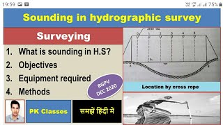
- Hydrographic Surveying
The science of measuring and describing the physical features of bodies of water.
- Nautical Charts
Maps designed specifically for marine navigation.
- Dredging
The process of removing sediment from the bottom of water bodies to maintain navigability.
- Environmental Impact Assessment
A process for evaluating the environmental consequences of proposed actions or projects.
- Seabed
The bottom of a body of water, where hydrographic surveys collect data.
Reference links
Supplementary resources to enhance your learning experience.