
Position Fixing Techniques
Enroll to start learning
You’ve not yet enrolled in this course. Please enroll for free to listen to audio lessons, classroom podcasts and take practice test.
Interactive Audio Lesson
Listen to a student-teacher conversation explaining the topic in a relatable way.
Shore-Based Methods
🔒 Unlock Audio Lesson
Sign up and enroll to listen to this audio lesson

Today, we will start discussing shore-based methods for position fixing. Can anyone tell me what they think this might involve?

Does it involve using landmarks on the shore?
Exactly! These methods use fixed points on land to help determine the location of a vessel. One common method is using range and bearings. Can someone tell me how range and bearings work?

Isn't range the distance from the shoreline? And bearings would be the angles from those landmarks?
Correct! We use the combination of both to pinpoint a vessel's position. Remember the acronym RB for Range and Bearings. Any questions about that?

What if there are no visible landmarks?
Great question! That's where intersecting lines of sight and horizontal sextant angles come in. They help surveyors establish position even without visible landmarks. Let's recap: we learned that shoreline methods can utilize fixed land points to determine a ship's location using RB, intersecting lines of sight, and sextant angles.
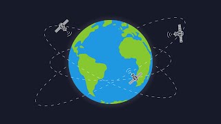
Radio and Satellite Methods
🔒 Unlock Audio Lesson
Sign up and enroll to listen to this audio lesson

Moving on, let's discuss radio and satellite methods. Who here has heard of DGPS?

I've heard it gives better accuracy than regular GPS!
That's right! DGPS uses fixed ground-based stations to correct GPS signals. This offers significantly improved accuracy. Can anyone explain how RTK-GPS differs?
RTK-GPS uses the phase of the signal for even higher accuracy, right?
Exactly! RTK-GPS can provide centimeter-level accuracy, making it ideal for detailed surveys. Remember the phrase 'Real Time, Kinematic Precision' to recall these key features. Any further questions?
What about total stations? How do they fit into this?
Excellent point! Total stations with prisms on boats are used for close surveys to measure distances and angles precisely. To summarize, we discussed how DGPS and RTK-GPS enhance position fixing accuracy, and how total stations can be utilized in nearshore environments.
Introduction & Overview
Read summaries of the section's main ideas at different levels of detail.
Quick Overview
Standard
This section discusses various techniques for fixing positions in hydrographic surveys, including shore-based methods like range and bearings, and advanced radio and satellite methods such as Differential GPS (DGPS) and Real-Time Kinematic GPS (RTK-GPS). Accurate position fixing is critical for creating precise maps of underwater features.
Detailed
Position Fixing Techniques
Position fixing techniques are vital in hydrographic surveying for ensuring the accuracy of data collected. Accurate positioning allows for reliable mapping of underwater features essential for navigation and construction. The main categories of position fixing techniques include:
Shore-Based Methods
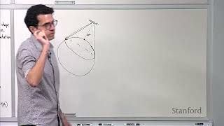
- Range and Bearings: This method involves the use of known points on land to determine the position of a boat or survey equipment at sea. Range refers to the distance from these points, while bearings relate to the angles.
- Intersecting Lines of Sight: By observing the angles from two or more known positions, a surveyor can determine the position where these lines intersect.
- Horizontal Sextant Angles: This technique uses a sextant to measure angles between various points, which helps in establishing the survey vessel's exact location.
Radio and Satellite Methods
- Differential GPS (DGPS): This method improves the accuracy of GPS by using a network of fixed ground-based reference stations that correct GPS signals, resulting in enhanced positional accuracy.
- Real-Time Kinematic GPS (RTK-GPS): RTK-GPS offers high precision (centimeter-level) by measuring the phase of the signal from the GPS satellites. It's particularly useful for close-range surveys.
- Total Stations with Prism on Boat: This technique involves using a total station placed on land in conjunction with a prism mounted on the boat to measure precise distances and angles for close-shore surveys.
By utilizing these position fixing techniques, hydrographic surveyors can achieve a high level of accuracy, ensuring the integrity of nautical charts and supporting safer maritime navigation.
Youtube Videos


Audio Book
Dive deep into the subject with an immersive audiobook experience.
Importance of Accurate Positioning
Chapter 1 of 3
🔒 Unlock Audio Chapter
Sign up and enroll to access the full audio experience
Chapter Content
Precise position of the sounding point is essential for accurate mapping.
Detailed Explanation
Accurate positioning refers to determining the exact location where measurements are taken in hydrographic surveying. This is critical because the accuracy of the data collected directly impacts the quality of the maps and charts produced. If the position of a sounding point is incorrect, the depth measurements will also be misplaced, leading to errors in navigational charts.
Examples & Analogies
Think about it like taking a photo of a landmark. If you accidentally take the photo from the wrong spot, such as a block away, the image won’t capture the landmark correctly. Just like in photography, accurate positioning in hydrographic surveying ensures that the ‘picture’ of the underwater features is clear and reliable.
Shore-Based Position Fixing Methods
Chapter 2 of 3
🔒 Unlock Audio Chapter
Sign up and enroll to access the full audio experience
Chapter Content
10.5.1 Shore-Based Methods
• Range and Bearings
• Intersecting Lines of Sight
• Horizontal Sextant Angles
Detailed Explanation
Shore-based methods are techniques used to determine the position of a survey vessel from fixed locations on land. Each method uses different principles:
- Range and Bearings: This method involves measuring the angle (bearing) and distance (range) from a known point on land to the vessel. Multiple such measurements help triangulate the precise location of the vessel.
- Intersecting Lines of Sight: This method requires two or more observers on shore who can see the vessel. By using sightlines and measuring angles relative to a fixed point, the exact position of the vessel can be determined by where these angles intersect.
- Horizontal Sextant Angles: A sextant is a navigational instrument used to measure angles. Observers use sextants to measure the angles between the survey vessel and known landmarks, which can then be used to calculate the vessel's position.
Examples & Analogies
Imagine you’re playing a game of treasure hunt. You and your friends are at fixed locations (like a park bench or a tree) and you can see your friend who's trying to find the treasure. By telling each other your angles and distances from your positions to the treasure, you can help your friend find it easily. This is similar to how shore-based position-fixing methods work.
Radio and Satellite Position Fixing Techniques
Chapter 3 of 3
🔒 Unlock Audio Chapter
Sign up and enroll to access the full audio experience
Chapter Content
10.5.2 Radio and Satellite Methods
• Differential GPS (DGPS)
• Real-Time Kinematic GPS (RTK-GPS)
• Total Stations with Prism on Boat (for close-shore surveys)
Detailed Explanation
Radio and satellite methods utilize technology to enhance positioning accuracy in hydrographic surveys:
- Differential GPS (DGPS): This technology uses ground-based reference stations that broadcast correction signals to GPS receivers on boats, significantly improving their accuracy.
- Real-Time Kinematic GPS (RTK-GPS): Similar to DGPS, RTK-GPS provides corrections in real-time using GPS data from a reference station, which allows for centimeter-level accuracy. This is crucial for detailed surveys where precision is paramount.
- Total Stations with Prism: This method involves using a total station fitted with a prism on the boat. It allows the measurement of distances and angles to and from fixed points on land (like the shore), facilitating accurate positioning during surveys close to the coast.
Examples & Analogies
Think of GPS as a game of catch. If you're trying to throw a ball to a friend, the more precise you are about where they are standing, the better your throw will be. DGPS and RTK-GPS are like advanced radar that help you pinpoint where your friend is to ensure your throw gets to them accurately, even if they move slightly.
Key Concepts
-
Shore-Based Methods: Utilizing fixed land points for determining vessel positions.
-
Radio and Satellite Methods: Advanced systems enhancing the accuracy of GPS signals.
-
Differential GPS (DGPS): Uses reference stations for improving GPS accuracy.
-
Real-Time Kinematic GPS (RTK-GPS): Provides high precision positioning through signal phase measurements.
Examples & Applications
Using a sextant at dusk to measure the angle of two known terrestrial points to determine your boat's position.
Implementing DGPS during a marine surveying operation to correct GPS readings in real-time.
Memory Aids
Interactive tools to help you remember key concepts
Rhymes
Fixing positions with ranges and sights, ensures our vessels navigate right.
Stories
Imagine a captain using landmarks to chart a course at twilight, willing to sail safely home guided by stable, sound measures.
Memory Tools
Remember R D S for Range, Bearings, and DGPS when fixing positions.
Acronyms
SBR
Shore-based methods
Bearings
and Radio methods for position fixing.
Flash Cards
Glossary
- Range
The distance from a known point on land to a vessel or survey equipment.
- Bearings
The angle between a reference direction and a line to an object or location.
- Differential GPS (DGPS)
An enhancement to GPS that provides improved location accuracy using ground-based reference stations.
- RealTime Kinematic GPS (RTKGPS)
A GPS technique that uses signal phase measurements to provide highly accurate location data in real-time.
- Total Station
An optical/electronic instrument used to measure distances and angles for surveying.
Reference links
Supplementary resources to enhance your learning experience.