
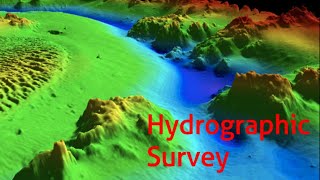
Classification of Hydrographic Surveys
Enroll to start learning
You’ve not yet enrolled in this course. Please enroll for free to listen to audio lessons, classroom podcasts and take practice test.
Interactive Audio Lesson
Listen to a student-teacher conversation explaining the topic in a relatable way.
Navigational Surveys
🔒 Unlock Audio Lesson
Sign up and enroll to listen to this audio lesson

Today, we will start by discussing navigational surveys. These are crucial as they help in charting coastlines and identifying underwater hazards. Why do you think this is important?

It’s important for ships and boats to navigate safely without hitting obstacles!
Exactly! We often use echo sounders and sonar in these surveys to map the marine environment. Can anyone tell me why echo sounders are preferred?

They provide depth measurements quickly!
Right! The speed and accuracy of these tools can help prevent accidents at sea. Let's remember this with the acronym 'SAFE' - S for Survey, A for Accurate, F for Fast, and E for Echo sounders.

That’s a good way to remember it!
Great! So, to summarize, navigational surveys are essential for safe navigation, using tools like echo sounders to ensure that ships can avoid underwater hazards.
Engineering Surveys
🔒 Unlock Audio Lesson
Sign up and enroll to listen to this audio lesson

Moving on, let's discuss engineering surveys. These surveys are conducted for construction projects such as harbors, bridges, and pipelines. What do you think is the purpose of these surveys?

To make sure the construction is done in the right place and that it’s safe!
Precisely! They gather essential data for planning and implementing safe and effective construction. Can anyone think of an example where this is important?
Maybe when building bridges over rivers?
Exactly! Engineering surveys ensure that all measurements take into account the underwater topography. A good mnemonic to remember these surveys could be 'BUILD' - B for Bridges, U for Underwater, I for Infrastructure, L for Location, D for Depth.
That's another good memory aid!
In summary, engineering surveys are vital for construction projects, helping to ensure safety and proper implementation.
Submarine Cable and Pipeline Surveys
🔒 Unlock Audio Lesson
Sign up and enroll to listen to this audio lesson
Next, let’s talk about submarine cable and pipeline surveys. Why do you think mapping the seafloor is crucial for these applications?
So they can lay cables and pipes without problems, right?
Exactly! These surveys help identify the best paths for laying infrastructure. What tools are typically used in these types of surveys?
Sonar systems to help see underwater features!
Correct! Sonar is essential here because it can map the seabed in detail. We can use a fun story to remember this: Think of the ocean as a hidden treasure map, where sonar helps us find safe paths to bury our treasure—cables and pipelines!
That’s a great visualization!
In summary, submarine cable and pipeline surveys are crucial for determining safe and effective paths for underwater infrastructure.
Resource Exploration Surveys
🔒 Unlock Audio Lesson
Sign up and enroll to listen to this audio lesson
Now, let’s focus on resource exploration surveys. These are used to assess underwater resources like minerals and oil. How do you think this impacts us?
We need those resources to power our homes and industries!
Absolutely! These surveys play a significant role in the sustainable management of resources. What techniques do you think are important for carrying these surveys out?
Maybe geological sampling and sonar mapping?
Exactly! We gather information on seabed composition using these methods. A useful acronym to remember here could be 'MAPS' - M for Minerals, A for Assessment, P for Projects, S for Sustainability.
That's catchy!
To sum up, resource exploration surveys help us locate and manage essential underwater resources.
Environmental and Scientific Surveys
🔒 Unlock Audio Lesson
Sign up and enroll to listen to this audio lesson
Finally, we have environmental and scientific surveys. Why do you think understanding marine ecology and water quality is important?
So we can protect marine life and understand our environment better!
Exactly! These surveys provide critical data for environmental assessments. What aspects do you think are assessed during these surveys?
Seabed composition and water quality!
Right! Oceanographers rely on this information to monitor ecological health. We can remember this field with the mnemonic 'ECO' - E for Ecology, C for Composition, O for Oceans.
I love how that fits!
To summarize, environmental and scientific surveys are vital for understanding and protecting marine ecosystems.
Introduction & Overview
Read summaries of the section's main ideas at different levels of detail.
Quick Overview
Standard
This section outlines the classification of hydrographic surveys, detailing various types such as navigational surveys for maritime safety, engineering surveys for construction, submarine cable surveys, resource exploration, and environmental studies. Understanding these classifications is essential for the application and execution of effective hydrographic surveys.
Detailed
Classification of Hydrographic Surveys
Hydrographic surveys, pivotal for maritime and coastal management, can be broadly classified based on their purpose. This classification facilitates understanding the objectives and required methods for various surveying tasks. The major types include:
- Navigational Surveys: These surveys focus on charting coastlines and identifying underwater hazards to ensure safe maritime navigation.
- Engineering Surveys: Conducted for projects such as harbor construction, bridges, pipelines, and coastal protection systems, these surveys provide critical data for engineering applications.
- Submarine Cable and Pipeline Surveys: Essential for mapping the seafloor, these surveys are conducted to facilitate the laying of underwater communication cables and pipelines.
- Resource Exploration Surveys: Aimed at assessing underwater resources such as mineral deposits, oil, or gas, these surveys are vital for resource management and exploration efforts.
- Environmental and Scientific Surveys: These focus on marine ecology, seabed composition, sediment transport, and water quality, emphasizing the need for understanding environmental impacts.
Recognizing the diverse purposes of hydrographic surveys enables practitioners to apply suitable techniques and methodologies, driving advancements in navigation, construction, environmental conservation, and resource management.
Youtube Videos


Audio Book
Dive deep into the subject with an immersive audiobook experience.
Overview of Hydrographic Surveys
Chapter 1 of 6
🔒 Unlock Audio Chapter
Sign up and enroll to access the full audio experience
Chapter Content
Hydrographic surveys are broadly classified based on their purpose:
Detailed Explanation
Hydrographic surveys refer to the process of collecting data about bodies of water. This section introduces the idea that hydrographic surveys can be organized into different categories based on their intended use. Understanding these categories helps us to know why surveys are conducted and how they can aid various industries.
Examples & Analogies
Imagine you want to build a playground. First, you'd need to assess the land where it will be built, checking for hills, soil types, and water levels. Similarly, hydrographic surveys assess underwater conditions to help in various fields, like construction or ecological preservation.
Navigational Surveys
Chapter 2 of 6
🔒 Unlock Audio Chapter
Sign up and enroll to access the full audio experience
Chapter Content
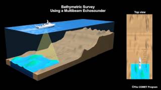
10.2.1 Navigational Surveys
Used to chart coastlines and underwater hazards for safe maritime navigation.
Detailed Explanation
Navigational surveys are essential for maritime safety. They help in identifying coastlines and any underwater dangers (like reefs or wrecks) that might pose risks to ships and boats. The data collected from these surveys is integral for creating nautical maps that guide vessels safely through waters.
Examples & Analogies
Think of navigational surveys like creating a detailed map for a hiking trail. Just as hikers need to know about steep cliffs or tricky paths to stay safe, ships need to know about hidden obstacles in the water.
Engineering Surveys
Chapter 3 of 6
🔒 Unlock Audio Chapter
Sign up and enroll to access the full audio experience
Chapter Content
10.2.2 Engineering Surveys
Conducted for construction of harbor works, bridges, pipelines, offshore rigs, and coastal protection structures.
Detailed Explanation
Engineering surveys focus on collecting data specifically for construction projects. They assess conditions and structures underwater to ensure safe and functional designs for harbors, bridges, pipelines, and other coastal works. This type of surveying plays a crucial role in understanding how the underwater environment can support or affect engineering projects.
Examples & Analogies
Consider an engineering survey like checking the foundation before building a house. Just as builders need to know if the ground is stable enough, engineers need to know how underwater conditions will impact their projects.
Submarine Cable and Pipeline Surveys
Chapter 4 of 6
🔒 Unlock Audio Chapter
Sign up and enroll to access the full audio experience
Chapter Content
10.2.3 Submarine Cable and Pipeline Surveys
Used to map the seafloor for laying underwater communication cables or pipelines.
Detailed Explanation
This type of survey focuses on preparing for the installation of underwater cables and pipelines. The surveys help map out the best paths for these installations while avoiding underwater hazards that could damage the cables or pipes. This ensures reliable communication and transport of resources.
Examples & Analogies
Think of this as laying down a road. Just like road builders survey land to avoid hills and rivers, submarine surveys ensure that cables and pipelines are laid in safe areas along the seafloor.
Resource Exploration Surveys
Chapter 5 of 6
🔒 Unlock Audio Chapter
Sign up and enroll to access the full audio experience
Chapter Content
10.2.4 Resource Exploration Surveys
Carried out to assess underwater mineral deposits, oil, or gas.
Detailed Explanation
Resource exploration surveys are crucial for identifying underwater resources such as minerals, oil, or natural gas. The data collected helps companies and governments understand where these valuable resources are located and how to extract them safely.
Examples & Analogies
Imagine treasure hunters searching for hidden gold. They need to know where to dig. Similarly, resource exploration surveys help industries locate and extract underwater treasures.
Environmental and Scientific Surveys
Chapter 6 of 6
🔒 Unlock Audio Chapter
Sign up and enroll to access the full audio experience
Chapter Content
10.2.5 Environmental and Scientific Surveys
Focus on understanding marine ecology, seabed composition, sediment transport, and water quality.
Detailed Explanation
These surveys are aimed at studying the environment and ecosystem of marine areas. They gather data on water quality, sediment movement, and biological communities, which is essential for conservation efforts and understanding the impacts of human activities on marine life.
Examples & Analogies
Think of this type of survey as a health check-up for the ocean. Just like doctors assess our health through tests and observations, scientists use environmental surveys to monitor the health of marine ecosystems.
Key Concepts
-
Navigational Surveys: Ensures safe maritime navigation by identifying underwater hazards.
-
Engineering Surveys: Supports construction projects, providing essential data for planning and implementation.
-
Submarine Cable & Pipeline Surveys: Maps the seafloor for safe installation of underwater cables and pipelines.
-
Resource Exploration Surveys: Assesses underwater resources like minerals, oil, and gas for management.
-
Environmental & Scientific Surveys: Monitors marine ecology and water quality for ecological health.
Examples & Applications
Navigational surveys help update maritime charts regularly to ensure ship safety in busy ports.
Engineering surveys are conducted prior to the construction of a new harbor to evaluate the seabed and underwater conditions.
Resource exploration surveys identify areas rich in oil deposits beneath the ocean floor, guiding extraction processes.
Environmental surveys assess the health of coral reefs and monitor water pollution levels in coastal areas.
Memory Aids
Interactive tools to help you remember key concepts
Rhymes
For navigational safety, we chart the great seas, avoiding underwater hazards with expertise.
Stories
Imagine a treasure hunt at sea. Our ship uses sonar to find safe pathways, ensuring that we can bury our treasure, like underwater cables, without a hitch!
Memory Tools
'ECO' for Environmental Surveys: E for Ecology, C for Conservation, O for Oceans.
Acronyms
'BUILD' for Engineering Surveys
for Bridges
for Underwater
for Infrastructure
for Location
for Depth.
Flash Cards
Glossary
- Hydrographic Surveying
The measurement and mapping of underwater features to determine the physical characteristics of bodies of water.
- Navigational Surveys
Surveys focused on mapping coastlines and underwater hazards to ensure safe navigation.
- Engineering Surveys
Surveys conducted for construction projects such as harbors, bridges, and other marine infrastructure.
- Submarine Cable and Pipeline Surveys
Survey methods used to map the seafloor for the installation of underwater cables and pipelines.
- Resource Exploration Surveys
Surveys aimed at assessing underwater mineral deposits, oil, or gas.
- Environmental and Scientific Surveys
Surveys focusing on understanding marine ecology and monitoring water quality.
Reference links
Supplementary resources to enhance your learning experience.