
Challenges in Hydrographic Surveying
Enroll to start learning
You’ve not yet enrolled in this course. Please enroll for free to listen to audio lessons, classroom podcasts and take practice test.
Interactive Audio Lesson
Listen to a student-teacher conversation explaining the topic in a relatable way.
Environmental Challenges
🔒 Unlock Audio Lesson
Sign up and enroll to listen to this audio lesson

Today, we're going to discuss some environmental challenges in hydrographic surveying. Can anyone think of what affects visibility in water?

Maybe things like sediment or pollution?
Exactly! Poor visibility from sedimentation or floating vegetation can complicate our measurements. What about other environmental hazards?

Coral reefs or rocks under the surface can confuse the sonar equipment.
Great point! These obstacles can distort sonar readings, which we must account for. Let's remember the acronym 'SCO' for Sedimentation, Coral, and Obstructions as key environmental challenges.

So, if we have poor visibility, how do we even get accurate data?
Good question! We often rely on more advanced equipment or alternative methods when conditions aren't ideal. Always be prepared!

What can be done to improve visibility?
Using underwater lights or conducting surveys at times of the day when natural light is best can help. Remember, a lot of planning goes into these surveys!
So let's recap our environmental challenges: Poor visibility, sedimentation effects, and obstacles like reefs. Make sure to keep SCO in mind!
Technical and Logistical Issues
🔒 Unlock Audio Lesson
Sign up and enroll to listen to this audio lesson

Now, let's talk about technical challenges. Why do you think equipment costs could be a barrier?
Because specialized equipment is usually pricey?
Exactly! High initial costs for gear and maintenance can hinder survey operations. What about data management challenges?
Well, with high-resolution imaging, there must be tons of data to sort through!
Precisely! This data overload requires skilled personnel who are adept with software to analyze everything. Remember, we can use the mnemonic 'DROID' for Data management, Resources, Operators, Infrastructure, and Details.
How do we manage all that data effectively?
Data management solutions include filtering data and validating readings. It's an ongoing process!
Wouldn’t it help to have more people trained on the equipment?
Absolutely! More trained personnel can make a significant difference in efficiency. Remember, DROID!
So in summary, we learned about technical challenges including equipment costs and data management issues highlighted by our mnemonic DROID.
Regulatory and Administrative Hurdles
🔒 Unlock Audio Lesson
Sign up and enroll to listen to this audio lesson
Finally, let’s address the regulatory hurdles faced in hydrographic surveying. Why can approvals take time?
Maybe because some areas are sensitive or international?
Correct! Sensitive zones often have strict regulations, causing delays. What about inter-agency cooperation?
If different agencies aren't in sync, it could lead to confusion, right?
Absolutely! Coordination is key. To remember, think of 'ACID' – Approvals, Cooperation, Inter-agency, Delays.
And how can we improve this situation?
Enhanced communication and planning among agencies can minimize these delays. Always be proactive!
So ACID reminds us about the regulatory challenges?
That's right! To summarize our regulatory hurdles, we learned about the importance of timeliness in approvals and inter-agency cooperation encapsulated with ACID.
Introduction & Overview
Read summaries of the section's main ideas at different levels of detail.
Quick Overview
Standard
The section outlines various challenges in hydrographic surveying such as environmental factors like visibility and sedimentation issues, technical difficulties associated with equipment and data management, and regulatory hurdles that can slow down survey processes in sensitive areas.
Detailed
Challenges in Hydrographic Surveying
Hydrographic surveying, while essential for navigation and various marine applications, faces multiple challenges that can affect its accuracy and efficiency. The most significant challenges can be categorized into three groups:
- Environmental Challenges:
- Poor Visibility: Conditions such as murky waters or extreme weather can limit the effectiveness of sonar and other measurement equipment.
- Sedimentation and Floating Vegetation: These can obscure measurements and complicate data collection, especially in shallow waters.
- Obstacles: Features like coral reefs and submerged rocks can cause sonar distortions, impacting the quality of the data collected.
- Technical and Logistical Issues:
- Equipment Costs: The high cost of specialized hydrographic equipment and the resources required for maintenance can be substantial barriers for organizations.
- Data Management Challenges: The advent of high-resolution sonar surveys often leads to data overload, necessitating advanced data processing and skilled personnel, which can strain resources.
- Skilled Labor Demands: There is a growing need for skilled manpower capable of operating sophisticated hydrographic software and equipment.
- Regulatory and Administrative Hurdles:
- Approval Delays: Conducting surveys in sensitive zones, especially near international waters, can experience bureaucratic delays.
- Coordination Challenges: Inadequate collaboration among marine, defense, and civil agencies can lead to inefficiencies and miscommunication, hampering survey progress.
These challenges highlight the complexities involved in hydrographic surveying, emphasizing the need for continuous improvements in technology and inter-agency cooperation to enhance survey efficacy.
Youtube Videos

Audio Book
Dive deep into the subject with an immersive audiobook experience.
Environmental Challenges
Chapter 1 of 3
🔒 Unlock Audio Chapter
Sign up and enroll to access the full audio experience
Chapter Content
• Poor visibility, sedimentation, and floating vegetation in shallow waters.
• Coral reefs and submerged rocks causing sonar distortions.
Detailed Explanation
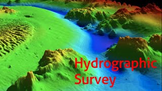
Environmental challenges in hydrographic surveying refer to obstacles that affect the clarity and accuracy of surveys conducted in water bodies. Poor visibility can be caused by factors such as turbidity in the water, which blocks light and makes it hard to see the underwater features. High sedimentation can also lead to an accumulation of particles in the water, making it challenging to get clear readings. Similarly, floating vegetation can obstruct access to the measurement points. Additionally, natural features like coral reefs and submerged rocks can interfere with sonar equipment, leading to distorted or inaccurate data.
Examples & Analogies
Imagine trying to take a photograph underwater in a murky lake. The dirt and plant life would blur the image, making it difficult to discern objects below. Similarly, hydrographic surveyors face challenges in visibility when trying to map the seafloor, which requires clear conditions to ensure accurate measurements.
Technical and Logistical Issues
Chapter 2 of 3
🔒 Unlock Audio Chapter
Sign up and enroll to access the full audio experience
Chapter Content
• High equipment cost and maintenance.
• Data overload from high-resolution sonar surveys.
• Skilled manpower and software expertise requirement.
Detailed Explanation
Technical and logistical issues highlight the complexities involved in conducting hydrographic surveys. The cost of high-quality surveying equipment, such as sonar devices and GPS systems, can be prohibitively expensive, which can limit the ability of organizations to carry out surveys consistently. Maintenance of this equipment is crucial, demanding both time and resources. Furthermore, high-resolution sonar surveys can generate vast amounts of data, which can be overwhelming to process and analyze effectively. A skilled workforce is required not only to operate this sophisticated equipment but also to analyze the large datasets using specialized software.
Examples & Analogies
Consider how a professional photographer may need expensive cameras and accessories to take high-quality photos. If they don’t know how to use the camera properly or edit the photos afterward, having the equipment alone won't ensure good results. In hydrographic surveying, similar challenges arise with equipment costs and the need for skills to interpret the data gathered.
Regulatory and Administrative Hurdles
Chapter 3 of 3
🔒 Unlock Audio Chapter
Sign up and enroll to access the full audio experience
Chapter Content
• Delays in approvals for survey areas near international waters or sensitive zones.
• Limited coordination among marine, defense, and civil agencies.
Detailed Explanation
Regulatory and administrative hurdles can significantly impede hydrographic surveying processes. When surveys are planned in areas close to international waters or sensitive ecological zones, they often require multiple approvals from various governmental agencies, which can take time. This can lead to delays and increased costs. Furthermore, a lack of coordination between marine, defense, and civil agencies can complicate survey activities, as overlapping jurisdictions may lead to redundancy in efforts and create confusion regarding responsibilities.
Examples & Analogies
Think of trying to organize a community event that requires permission from various local authorities. If one department takes too long to approve its part, the whole event can be delayed. Similarly, hydrographic surveys can get stalled if the necessary regulatory approvals are not obtained in a timely manner.
Key Concepts
-
Environmental Challenges: Factors affecting visibility and measurement including sediment and submerged obstacles.
-
Technical and Logistical Issues: Problems arising from equipment costs, data overload, and the need for skilled operators.
-
Regulatory Hurdles: Delays in survey approvals and the importance of cooperation between agencies.
Examples & Applications
A survey conducted in a fishing region where sedimentation affected the ability to gather accurate data.
A hydrographic survey in a coral reef habitat that experienced sonar distortions due to underwater structures.
Memory Aids
Interactive tools to help you remember key concepts
Rhymes
When surveying the seas, watch for sediment ease, keep tools in good shape, avoid regulatory tape.
Stories
Imagine a team of hydrographers faced with a murky lake filled with weeds. They remember SCO (Sedimentation, Coral, Obstructions) and proceed carefully, using lights to enhance visibility and navigating safely to trust their readings.
Memory Tools
Use ACID to recall the regulatory hurdles: Approvals, Cooperation, Inter-agency, Delays.
Acronyms
Remember DROID
Data
Resources
Operators
Infrastructure
Details for technical issues.
Flash Cards
Glossary
- Sedimentation
The process by which particles settle out of a fluid, leading to obscured visibility and measurement in hydrography.
- Sonar Distortions
Interference in sonar signals caused by underwater features that can affect depth readings.
- Data Overload
The condition when too much data is collected, making it difficult to process and analyze effectively.
- ACID
A mnemonic encapsulating Approvals, Cooperation, Inter-agency, Delays, related to regulatory hurdles.
- DROID
Mnemonic for Data management, Resources, Operators, Infrastructure, and Details that highlights technical and logistical concerns.
Reference links
Supplementary resources to enhance your learning experience.