
Hydrographic Survey Equipment
Enroll to start learning
You’ve not yet enrolled in this course. Please enroll for free to listen to audio lessons, classroom podcasts and take practice test.
Interactive Audio Lesson
Listen to a student-teacher conversation explaining the topic in a relatable way.
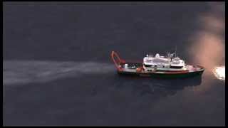
Survey Vessels
🔒 Unlock Audio Lesson
Sign up and enroll to listen to this audio lesson

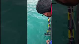
Let's start with survey vessels. These are specialized boats or ships equipped with essential hydrographic surveying tools. Why do you think the type of vessel is important in hydrographic surveying?

I think it needs to be sturdy enough to face the conditions at sea!
Exactly! The vessels also need to be equipped with echo sounders, GNSS receivers, and powerful computers for data processing. What role do you think GNSS receivers play in these vessels?

They help with accurate positioning while surveying!
Very good! Remember, accurate positioning is essential for mapping. Let's summarize: survey vessels are critical as they facilitate data collection and ensure navigational precision.
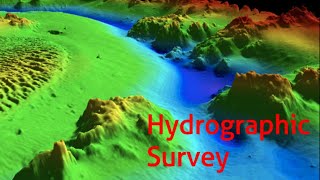
Echo Sounders and Sonars
🔒 Unlock Audio Lesson
Sign up and enroll to listen to this audio lesson

Moving on, let's discuss echo sounders and sonars. These instruments measure the depth of water and provide information on underwater topography. Can someone explain how a Single Beam Echo Sounder works?

Isn’t it that it sends a sound pulse down and measures how long it takes to return?
Correct! That's exactly how it works. Now, what are the advantages of using Multi-Beam Echo Sounders over Single Beam ones?

Multi-Beam Echo Sounders can cover a wider area and provide detailed maps, right?
Absolutely! Summarizing, echo sounders vary in their capabilities, with multi-beam options offering more detail and coverage.
GPS/GNSS Units
🔒 Unlock Audio Lesson
Sign up and enroll to listen to this audio lesson
Next, let's talk about GPS and GNSS units. Who can explain the difference between GPS and GNSS?
GPS is the American system, while GNSS is a broader term that includes all satellite navigation systems, like GLONASS and Galileo.
Excellent explanation! How do these systems enhance hydrographic surveying?
They provide real-time positioning, helping surveyors accurately mark the locations of soundings.
Exactly! These units are essential for creating accurate navigational charts, which is why GPS/GNSS units are indispensable in hydrographic surveys.
Motion Sensors and Gyroscopes
🔒 Unlock Audio Lesson
Sign up and enroll to listen to this audio lesson
Now let's look at motion sensors and gyroscopes. Can anyone tell me their purpose in hydrographic surveying?
They help to compensate for the movements of the vessel, right?
That's precisely right! How does this impact data collection?
It ensures that the depth readings are accurate, even when the vessel is moving.
Great insights! To recap, without these technologies, we could end up with inaccurate depth measurements that misrepresent the underwater landscape.
Introduction & Overview
Read summaries of the section's main ideas at different levels of detail.
Quick Overview
Standard
Hydrographic surveying relies on specialized equipment such as survey vessels, echo sounders, GPS units, motion sensors, and data loggers to accurately collect data about bodies of water. Each type of equipment plays a critical role in ensuring the precision and efficiency of hydrographic studies.
Detailed
Hydrographic Survey Equipment
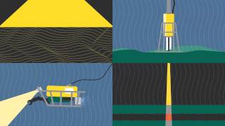
Hydrographic surveying is a critical process that requires various specialized instruments to gather accurate and reliable data about underwater features and characteristics. This section provides an overview of the essential equipment used in hydrographic surveys, focusing on five main categories:
1. Survey Vessels
These boats or ships are equipped with essential tools like echo sounders, Global Navigation Satellite System (GNSS) receivers, and computers to facilitate data collection and navigation during surveys.
2. Echo Sounders and Sonars
These are depth measurement instruments that use transducers and processing units to determine underwater topography. They include tools such as Single Beam Echo Sounders (SBES) and Multi-Beam Echo Sounders (MBES), which vary in their capabilities for different depths and detail levels.
3. GPS/GNSS Units
These units provide real-time positioning and navigation, ensuring that the location of each measurement can be accurately recorded and later referenced on nautical charts.
4. Motion Sensors and Gyroscopes
Utilized to compensate for the movement of survey vessels, these devices help correct data for pitch, roll, and yaw, thereby enhancing the overall accuracy of the collected hydrographic data.
5. Data Loggers and Computers
These are essential for storing, visualizing, and post-processing the extensive data collected during hydrographic surveys. They help in converting raw data into usable formats for analysis and charting.
Together, these equipment categories form the backbone of hydrographic surveying, allowing for the efficient gathering and processing of critical underwater data.
Youtube Videos

Audio Book
Dive deep into the subject with an immersive audiobook experience.
Survey Vessels
Chapter 1 of 5
🔒 Unlock Audio Chapter
Sign up and enroll to access the full audio experience
Chapter Content
• Boats or ships equipped with echo sounders, GNSS receivers, computers.
Detailed Explanation
Survey vessels are specialized boats or ships designed specifically for hydrographic surveying. They are equipped with advanced technology including echo sounders, GNSS (Global Navigation Satellite System) receivers, and computers. The echo sounders measure the depth of water by emitting sound waves and recording the time it takes for them to bounce back after hitting the seabed. The GNSS receivers help in determining the precise location of the vessel, ensuring accurate mapping of the underwater features.
Examples & Analogies
Think of a survey vessel like a moving laboratory on water. Just like a chef uses various tools in a kitchen to create a dish, hydrographic surveyors use these vessels equipped with specialized tools to create underwater maps, which are essential for safe navigation and construction projects.
Echo Sounders and Sonars
Chapter 2 of 5
🔒 Unlock Audio Chapter
Sign up and enroll to access the full audio experience
Chapter Content
• Depth measurement instruments with transducers and processing units.
Detailed Explanation
Echo sounders and sonars are instruments that play a crucial role in determining the depth of water bodies. Echo sounders consist of transducers that send out sound waves into the water; when these waves hit the seabed, they bounce back to the transducer. The device then calculates the water depth based on the time taken for the waves to return. Similarly, sonar is used to create images of the underwater landscape, helping surveyors visualize features such as underwater rocks and shipwrecks.
Examples & Analogies
Imagine throwing a pebble into a pond; you can see the ripples spreading out. Now think of the echo sounder as a device that throws a sound instead of a pebble but listens for the 'ripples' (sound waves) coming back. This 'conversation' helps us understand what’s beneath the water surface.
GPS/GNSS Units
Chapter 3 of 5
🔒 Unlock Audio Chapter
Sign up and enroll to access the full audio experience
Chapter Content
• For real-time positioning and navigation.
Detailed Explanation
GPS and GNSS units are essential for determining the exact location of the survey vessel during hydrographic surveys. These systems use signals from satellites orbiting the earth to provide real-time positioning data. This information is critical for mapping underwater features accurately and ensuring that navigational charts are reliable.
Examples & Analogies
Just like how our smartphones use GPS to help us find directions while driving or walking, hydrographic surveyors rely on GNSS to pinpoint their location on the water. This helps them ensure they are surveying the exact area they need to map.
Motion Sensors and Gyroscopes
Chapter 4 of 5
🔒 Unlock Audio Chapter
Sign up and enroll to access the full audio experience
Chapter Content
• Compensate for vessel motion (pitch, roll, yaw).
Detailed Explanation
Motion sensors and gyroscopes are used to stabilize measurements taken by the surveying equipment. When a vessel is on the water, it can experience movements such as pitching (tilting forward or backward), rolling (tilting side to side), and yawing (turning left or right). These sensors help correct the data collected by echo sounders, ensuring that the depth measurements are accurate despite the vessel's movement.
Examples & Analogies
Think of a motion sensor as the stabilizer on a video camera that helps keep the picture steady while you're filming on a bumpy ride. In hydrographic surveying, these sensors do the same job by ensuring accurate readings despite the vessel's movements on the waves.
Data Loggers and Computers
Chapter 5 of 5
🔒 Unlock Audio Chapter
Sign up and enroll to access the full audio experience
Chapter Content
• For storage, visualization, and post-processing of hydrographic data.
Detailed Explanation
Data loggers and computers are used to collect, store, and analyze data gathered during hydrographic surveys. Data loggers record the information in real-time as the survey is conducted, while computers help visualize and process this data into usable formats, such as charts and maps. This technology allows surveyors to compile comprehensive reports and make informed decisions about navigation and construction.
Examples & Analogies
Imagine a student taking notes during a lecture and later organizing them into a study guide. Similarly, data loggers collect information during the surveying process, and computers help organize and analyze that information for better understanding and presentation.
Key Concepts
-
Survey Vessels: Specialized boats or ships used to conduct hydrographic surveys.
-
Echo Sounders: Instruments that measure depth using sound waves.
-
GNSS: Global Navigation Satellite System which provides real-time positioning.
-
Motion Sensors: Devices that compensate for the movement of the vessel.
-
Data Loggers: Tools for storing and processing data collected during surveys.
Examples & Applications
An example of a survey vessel is a catamaran equipped with multi-beam echo sounders for detailed depth mapping.
A portable data logger can be used to collect and store depth data continuously as the vessel moves along predefined paths.
Memory Aids
Interactive tools to help you remember key concepts
Rhymes
Survey vessels bob and sway, gathering data every day.
Stories
Imagine Captain Seaborn navigating the waves, his ship equipped with echo sounders, charting the depths and ensuring safe travels across the oceans.
Memory Tools
Remember 'VESSEL': V for vessel, E for echo sounder, S for sonar, S for sensors, E for efficiency, L for loggers.
Acronyms
Use 'SEAMS' to remember five key tools
for Survey Vessels
for Echo Sounders
for Accuracy tools like sensors
for Motion devices
for Storage loggers.
Flash Cards
Glossary
- Survey Vessels
Boats or ships equipped with tools for hydrographic surveys.
- Echo Sounders
Instruments that measure water depth using sound waves.
- GNSS (Global Navigation Satellite System)
A satellite-based navigation system that provides real-time positioning.
- Motion Sensors
Devices that detect and compensate for the motion of the survey vessel.
- Data Loggers
Devices used for storing and processing survey data.
Reference links
Supplementary resources to enhance your learning experience.