
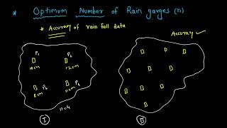
Density of Rain Gauge Network
Enroll to start learning
You’ve not yet enrolled in this course. Please enroll for free to listen to audio lessons, classroom podcasts and take practice test.
Interactive Audio Lesson
Listen to a student-teacher conversation explaining the topic in a relatable way.
WMO Guidelines
🔒 Unlock Audio Lesson
Sign up and enroll to listen to this audio lesson

Today, we're focusing on the World Meteorological Organization's guidelines for rain gauge network density. Can anyone tell me why the density of rain gauges is important?

It helps collect accurate rainfall data!
Correct! Let’s break down the WMO guidelines. In flat regions, what's the recommended density?

One gauge per 625 square kilometers.
Yes! And what about hilly regions?

One per 250 square kilometers!
Great! Now who can remember the density needed for mountainous regions?

One per 100 square kilometers.
Exactly! For urban areas, what density do we need?
One gauge per 50 square kilometers.
Amazing! It's crucial because urban areas have complex rainfall patterns that require denser networks. Let’s recap: Flat is 625, hilly is 250, mountainous is 100, and urban is 50. Remember this with the acronym 'FHMU'.
IMD Standards
🔒 Unlock Audio Lesson
Sign up and enroll to listen to this audio lesson

Now let's talk about the Indian Meteorological Department's guidelines. Why do you think these could be more stringent?
Because India has diverse climates and flood risks!
Right! The IMD often tailors their recommendations based on river basin and watershed characteristics. Why do you think this is important?
To ensure maximum data accuracy for flood forecasting and agriculture!
Exactly! Ensuring adequate density can help mitigate disaster risks. How can we remember the importance of these standards?
We can say 'Density saves lives'!
Perfect! Let's summarize the importance of tailored density guidelines in ensuring effective rainfall measurement.
Introduction & Overview
Read summaries of the section's main ideas at different levels of detail.
Quick Overview
Standard
The section outlines the guidelines provided by the World Meteorological Organization (WMO) and the Indian Meteorological Department (IMD) regarding the minimum recommended density of rain gauges. It emphasizes the relationship between rain gauge density and geographic regions, affecting the accuracy of hydrological studies.
Detailed
Density of Rain Gauge Network
The density of a rain gauge network is crucial for accurate precipitation measurement. The World Meteorological Organization (WMO) provides guidelines to ensure sufficient gauge densities based on geographic characteristics:
- Flat Regions: A minimum of 1 gauge per 625 km².
- Hilly Regions: A minimum of 1 gauge per 250 km².
- Mountainous Regions: A minimum of 1 gauge per 100 km².
- Urban Areas: A denser network of 1 gauge per 50 km².
In addition to WMO guidelines, the Indian Meteorological Department (IMD) has more stringent standards, particularly tailored for river basins and micro-watersheds, emphasizing the importance of density in the successful design of hydrological systems.
The correct gauge density ensures reliable data for various hydrological applications, including flood forecasting, agricultural planning, and infrastructure design.
Youtube Videos


Audio Book
Dive deep into the subject with an immersive audiobook experience.
WMO Guidelines
Chapter 1 of 2
🔒 Unlock Audio Chapter
Sign up and enroll to access the full audio experience
Chapter Content
The World Meteorological Organization (WMO) provides general guidelines for the minimum recommended density of rain gauges:
Type of Region Min. No. of Gauges per sq. km
Flat Region 1 per 625 km²
Hilly Region 1 per 250 km²
Mountainous Region 1 per 100 km²
Urban Areas 1 per 50 km²
Detailed Explanation
The World Meteorological Organization (WMO) has established guidelines on the minimum number of rain gauges needed to effectively monitor rainfall in different types of regions. For flat regions, one gauge is recommended per 625 square kilometers, while hilly regions require denser coverage of one gauge per 250 square kilometers. In mountainous areas, the density increases to one gauge per 100 square kilometers due to the greater variability in rainfall caused by elevation changes. Urban areas, with their unique rainfall patterns and the potential for runoff increases, require the highest density of gauges—one per 50 square kilometers.
Examples & Analogies
Imagine you're trying to catch raindrops in a bucket at a picnic. If you're in an open, flat park, one bucket at the corner might be enough. However, if you're in a hilly area, where rain may pool in certain spots, you would need more buckets to ensure you don't miss any water. In cities, with buildings and streets altering rain patterns, placing more buckets helps to capture all the raindrops that might otherwise go unrecorded.
Indian Standards
Chapter 2 of 2
🔒 Unlock Audio Chapter
Sign up and enroll to access the full audio experience
Chapter Content
The Indian Meteorological Department (IMD) also gives guidelines, particularly for different river basin regions and micro-watersheds. The IMD standards are often more stringent for hydrological design.
Detailed Explanation
The Indian Meteorological Department (IMD) sets its own guidelines for rain gauge density, which are generally stricter than WMO recommendations. These guidelines take into account specific regional characteristics, such as varying rainfall patterns across different river basins and micro-watersheds. This specificity ensures that data collection is sufficiently accurate for local hydrological studies and flood management, thereby assisting in more precise water resource planning.
Examples & Analogies
Think of a painter who uses different brushes for different sizes of canvases. Just as a painter selects the right tools to get the desired effect, the IMD tailors its rain gauge recommendations to fit the unique landscapes and weather conditions of India. This way, they can accurately capture the complexities of the region's rainfall patterns, much like using the right brush helps create a masterpiece.
Key Concepts
-
Rain Gauge Density: The number of rain gauges required per unit area to capture accurate rainfall data.
-
WMO Guidelines: Recommended density measures for optimal rain gauge placement, varying by geographical characteristics.
-
IMD Standards: Specific guidelines provided by the Indian Meteorological Department for rain gauge density tailored to India’s unique climatic needs.
Examples & Applications
Example of rain gauge distribution in urban areas where high density is crucial for recording rainfall accurately due to rapid urbanization.
Comparison of rainfall datasets from hilly regions requiring denser networks to account for variations in precipitation.
Memory Aids
Interactive tools to help you remember key concepts
Rhymes
Flat is wide, 625 is the guide, hilly is 250, keep data alive.
Stories
Imagine a flat land requiring few gauges, while hilly terrains dance with rain, needing more to keep track of the array.
Memory Tools
FHMU: Flat Hilly Mountainous Urban guides you to remember densities!
Acronyms
WMO for the world, IMD for India; these benchmarks help keep rainfall data neat and handy.
Flash Cards
Glossary
- Rain Gauge Network
A system of multiple rain gauges distributed over a geographical area to collect precipitation data.
- WMO
World Meteorological Organization, which provides guidelines for meteorological practices, including rain gauge density.
- IMD
Indian Meteorological Department, which sets standards for meteorological data collection in India.
- Precipitation
Any form of water, liquid or solid, that falls from clouds and reaches the ground.
Reference links
Supplementary resources to enhance your learning experience.