
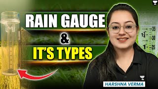
Rain Gauge Network – Basic Concepts
Enroll to start learning
You’ve not yet enrolled in this course. Please enroll for free to listen to audio lessons, classroom podcasts and take practice test.
Interactive Audio Lesson
Listen to a student-teacher conversation explaining the topic in a relatable way.
Introduction to Rain Gauge Networks
🔒 Unlock Audio Lesson
Sign up and enroll to listen to this audio lesson

Today we're learning about rain gauge networks. Can anyone tell me why measuring rainfall is important?

It's important for agriculture, to know how much water crops get!
Exactly! Very good. Measuring rainfall helps farmers plan irrigation effectively. But how do we measure rainfall? Any ideas?

Using rain gauges?
Correct! A whole system of these is called a rain gauge network. This network captures data from various locations. Can anyone think of why we need multiple gauges?

To cover different areas? Because rainfall can change a lot in a small region?
Exactly! That's called spatial variability. It's crucial for getting accurate rainfall estimates.

What if there's a huge storm? Will one gauge be enough?
Good point! During storms, having multiple gauges helps detect extreme weather. This leads us to our next topic about what objectives these networks serve.
So, to summarize, a rain gauge network allows us to measure point rainfall, estimate areal precipitation, understand rainfall distribution, and detect weather anomalies.
Key Objectives of Rain Gauge Networks
🔒 Unlock Audio Lesson
Sign up and enroll to listen to this audio lesson

Now let's delve into the key objectives of a rain gauge network. What do we aim to achieve with this network?
We measure the amount of rain at different points!
Yes! This is known as measuring point rainfall. Why is that valuable?
Because it helps us know how much water is available in different spots?
Exactly! That's also tied to estimating areal precipitation, which is about calculating rainfall over larger areas. How can this be useful?
In planning water resources for cities!
Absolutely! Additionally, these networks help us study spatial and temporal distribution of rainfall. What do we mean by these terms?
Spatial refers to how rainfall differs in space, and temporal refers to changes over time!
That's right! By understanding when and where rain occurs, we can better prepare for events. Can anyone give an example of why detecting anomalies is important?
If we see unusual patterns, it could mean a flood is coming!
Exactly! Monitoring these anomalies allows us to take precautionary steps. Let's summarize today's key objectives: we measure point rainfall, estimate areal precipitation, study rainfall distribution, and detect anomalies.
Introduction & Overview
Read summaries of the section's main ideas at different levels of detail.
Quick Overview
Standard
A rain gauge network consists of multiple gauges strategically placed across a geographical area to collect rainfall data. This section highlights the objectives of such networks, including measuring point rainfall, estimating areal precipitation, studying rainfall distribution, and detecting anomalies. Key factors influencing the design and placement of these networks are also discussed.
Detailed
Rain Gauge Network – Basic Concepts
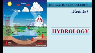
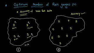
A rain gauge network is an essential system composed of several rain gauges distributed across a specific geographic area. The primary goal of this network is to effectively capture the spatial variability of rainfall, thereby ensuring statistically reliable data collection that is vital for various hydrological studies, flood forecasting, and agricultural planning.
Key Objectives of a Rain Gauge Network
- Measure Point Rainfall: This involves recording rainfall at multiple points to understand local variations.
- Estimate Areal Precipitation: Gauges help in calculating the overall precipitation across a larger area.
- Study Spatial and Temporal Distribution: Analyzing rainfall over time and space can reveal patterns and trends in weather conditions.
- Detect Anomalies and Extreme Weather Events: Networks help identify unusual weather patterns, which is crucial for timely warnings and disaster management.
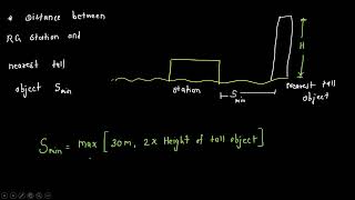
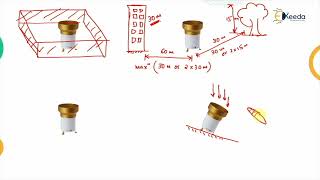
The effectiveness of rainfall analysis hinges on the appropriate placement and density of these gauges, which in turn affects data quality and reliability.
Youtube Videos

Audio Book
Dive deep into the subject with an immersive audiobook experience.
Overview of Rain Gauge Networks
Chapter 1 of 2
🔒 Unlock Audio Chapter
Sign up and enroll to access the full audio experience
Chapter Content
A rain gauge network comprises multiple rain gauges distributed over a specific geographical area to collect rainfall data at different locations. The network should be dense enough to capture spatial variability and provide statistically reliable data.
Detailed Explanation
A rain gauge network is a system made up of several rain gauges located at different points within an area. Each gauge measures rainfall at its spot. Having many gauges in various locations is important because rainfall can vary significantly from one place to another due to topography, urban structures, and local climate conditions. The density of the network—that is, how many gauges are placed within a geographical area—is crucial. A denser network means better data collection, allowing for more accurate rainfall analysis.
Examples & Analogies
Imagine you are trying to understand how much it rains in a city. If you only put one rain gauge at the center of the city, you might miss out on what happens in the outskirts or in hilly areas where it could rain more. It's like taking one person's opinion to decide the overall mood of a party—if you only ask one person in one corner, you might get a skewed view of how everyone is actually feeling.
Key Objectives of Rain Gauge Networks
Chapter 2 of 2
🔒 Unlock Audio Chapter
Sign up and enroll to access the full audio experience
Chapter Content
- To measure point rainfall at various locations
- To estimate areal precipitation
- To study spatial and temporal distribution of rainfall
- To detect anomalies and extreme weather events
Detailed Explanation
Rain gauge networks serve several essential functions. First, they measure precipitation at distinct points—this is vital for understanding how much rain falls in different locations. Second, they help estimate areal precipitation, which combines data from various gauges to give a broader picture of rainfall over an area. Third, these networks analyze how rainfall changes over time and space. Finally, they help identify unusual weather patterns or extreme rainfall events, which is crucial for forecasting and preparing for potential flooding.
Examples & Analogies
Think of a rain gauge network like a group of scientists conducting an experiment. Each scientist (gauge) measures something specific in their small area. When they combine their results, they can see trends and patterns that inform them whether they’re dealing with normal conditions or something unusual, like a sudden storm—much like how experts who work on climate change look for patterns in global temperatures from various weather stations.
Key Concepts
-
Rain Gauge Network: A system of rain gauges for collective data acquisition.
-
Spatial Variability: Differences in rainfall across various locations.
-
Areal Precipitation: Total rainfall estimated over a larger area.
-
Anomalies: Unexpected rainfall data patterns signaling extreme weather.
Examples & Applications
A rain gauge network is established in a hilly region to monitor rainfall during a planned agricultural project, ensuring crops receive adequate water.
During a significant weather event, multiple gauges in a rain gauge network record extreme rainfall, allowing for timely flood alerts.
Memory Aids
Interactive tools to help you remember key concepts
Rhymes
To measure rain, one should know, Many gauges help data flow.
Stories
Once in a town, 5 gauges stood, They measured rainfall, just as they should. When clouds gathered, they all saw, The town prepared, without a flaw.
Memory Tools
Remember the acronym RISE: Rainfall, Interpolate, Study, Estimate, to capture the main objectives of a rain gauge network.
Acronyms
RAIN = Rain Gauge, Anomalies, Interpolation, Networks.
Flash Cards
Glossary
- Rain Gauge Network
A system of multiple rain gauges distributed over a region to assess rainfall data.
- Spatial Variability
The uneven distribution of rainfall across different geographical areas.
- Areal Precipitation
The total precipitation over a specified area, derived from measurements at multiple points.
- Anomalies
Unusual or unexpected patterns in rainfall data, which can indicate extreme weather events.
Reference links
Supplementary resources to enhance your learning experience.