
Network Layout and Spatial Coverage
Enroll to start learning
You’ve not yet enrolled in this course. Please enroll for free to listen to audio lessons, classroom podcasts and take practice test.
Interactive Audio Lesson
Listen to a student-teacher conversation explaining the topic in a relatable way.
Uniform Grid Network Layout
🔒 Unlock Audio Lesson
Sign up and enroll to listen to this audio lesson

Let’s start by discussing the concept of a uniform grid layout. This entails placing rain gauges in equidistant patterns across the region. Can anyone tell me the potential pros and cons of this layout?

I think it's easy to set up, but it might miss some areas that get more rain, like hills.
Exactly! It’s simple to implement, but we can miss critical variances in rainfall caused by geographical features. This is why understanding topographical influences is important. Can you think of circumstances where a uniform grid might be useful?

Maybe in small, flat areas where rainfall is fairly consistent?
Spot on! A uniform grid can work well in flat regions. Now let's move on to layouts that take geography into account.
Topography-Based Layout
🔒 Unlock Audio Lesson
Sign up and enroll to listen to this audio lesson

In a topography-based layout, we prioritize gauge placement in areas like hilltops and valleys. Why do you think this layout is more effective in hilly regions?

Because rain can vary a lot on hills compared to flat areas, right?
Absolutely! Orographic lift often increases rainfall on the windward side of mountains. If we don’t account for this, we could miss heavy rainfall data. How might this impact flood forecasting?

If we don’t have enough data from those areas, it could lead to underestimating the risk of flooding.
Exactly! This is a critical aspect of designing effective rain gauge networks.
Watershed-Based Layout
🔒 Unlock Audio Lesson
Sign up and enroll to listen to this audio lesson
Now, let’s discuss the watershed-based layout. By placing gauges at hydrologically significant points, we can better monitor the effect of rainfall on local water bodies. What do you think some advantages are?
We can get a clearer picture of how much water is flowing into rivers and lakes!
Exactly! And it helps in water management and planning. However, what challenges do you think may arise from this approach?
We might need more resources to monitor all those specific points effectively.
Right! It requires careful planning and resources, highlighting how balance is needed between adequacy and practicality.
GIS and Network Optimization
🔒 Unlock Audio Lesson
Sign up and enroll to listen to this audio lesson
We now arrive at GIS technology’s role in rain gauge layout. GIS allows us to visualize rainfall patterns. Why is this advantageous?
We can see where we have gaps in data collection and adjust our network.
Exactly! Seeing data visually helps in planning more effective networks. Can anyone suggest how remote sensing might complement this?
It can provide rainfall estimates for areas where we can't place gauges easily!
Absolutely! Utilizing all available technologies ensures we’re capturing the most accurate rainfall data possible.
Introduction & Overview
Read summaries of the section's main ideas at different levels of detail.
Quick Overview
Standard
Different patterns for arranging rain gauges are explored, including uniform grids, topography-based layouts, and watershed-based designs, all aimed at optimizing rainfall data collection. The significance of Geographic Information Systems (GIS) and remote sensing technology in visualizing and enhancing network spatial coverage is also highlighted.
Detailed
Network Layout and Spatial Coverage
The effective spatial arrangement of rain gauges is critical for accurate precipitation data collection. There are several layout options for deploying rain gauges:
- Uniform Grid: This is a simple approach where gauges are placed equidistantly across an area. While it provides systematic coverage, it may overlook natural geographical features that affect rainfall distribution.
- Topography-Based Layout: This strategy prioritizes the placement of gauges in areas such as hilltops, valleys, and slopes to better capture the spatial variability presented in mountainous or undulating terrains.
- Random or Stratified Random Sampling: In this method, gauges are positioned randomly or in stratified groups based on specific criteria to enhance representativeness while minimizing bias.
- Watershed-Based Layout: This involves placing gauges at hydrologically significant points within a watershed, allowing for effective monitoring and analysis of precipitation impacts on water bodies and drainage patterns.
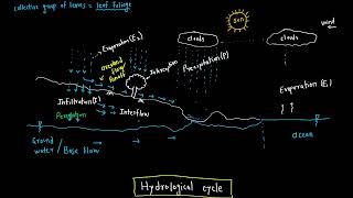
The integration of Geographic Information Systems (GIS) and remote sensing technologies plays a crucial role in visualizing these layouts and optimizing gauge placement based on spatial distribution and variability of rainfall. This section underlines the necessity of thoughtful design in rain gauge networks to ensure effective and accurate data acquisition, which is pivotal for hydrological and climate studies.
Youtube Videos


Audio Book
Dive deep into the subject with an immersive audiobook experience.
Spatial Arrangement of Rain Gauges
Chapter 1 of 2
🔒 Unlock Audio Chapter
Sign up and enroll to access the full audio experience
Chapter Content
The spatial arrangement of gauges can follow patterns like:
• Uniform grid: Simple but may not consider natural features
• Topography-based layout: Prioritizes hilltops, valleys, slopes, etc.
• Random or stratified random sampling: Involves statistical randomness
• Watershed-based layout: Places gauges at hydrologically significant points
Detailed Explanation
This chunk discusses how rain gauges can be positioned in different arrangements across a geographical area to optimize data collection. Each arrangement pattern has its strengths and weaknesses.
- A Uniform grid is easy to set up but may fail to account for important natural features (like rivers or mountains) that affect rainfall patterns.
- A Topography-based layout takes into account the physical features of the landscape, placing gauges at hilltops and valleys where rainfall may significantly vary.
- Random or stratified random sampling uses statistical tools to randomly distribute gauges, which can help in obtaining a more representative sample of rainfall across different regions.
- The Watershed-based layout focuses on areas critical for hydrology, ensuring gauges are placed where they can capture significant changes in rainfall that could affect water flow and storage in watersheds.
Examples & Analogies
Think of arranging rain gauges like placing cameras to capture different angles of a landscape. A simple grid might capture broad views, but to get a real sense of the beauty and variability of the landscape (like hilltops or valleys), you would want to place cameras strategically in those significant locations, much like a topography-based layout for rain gauges.
Role of GIS and Remote Sensing
Chapter 2 of 2
🔒 Unlock Audio Chapter
Sign up and enroll to access the full audio experience
Chapter Content
Use of GIS and remote sensing helps visualize and optimize the network.
Detailed Explanation
This chunk emphasizes the importance of Geographic Information Systems (GIS) and remote sensing technologies in designing and managing rain gauge networks. GIS allows for effective mapping and analysis of spatial data, helping planners visualize where gauges should be placed based on various factors like population density, land use practices, and historical rainfall data. Remote sensing adds an additional layer by providing satellite or aerial imagery that can highlight areas of interest that may not be adequately monitored by ground gauges.
Examples & Analogies
Consider a school wanting to improve its playground layout. Using aerial photographs or GIS software, they could visualize the entire area, noting where sunlight hits the hardest or where trees cast shade. This way, they can optimally place equipment, much like how GIS aids in the optimal layout of a rain gauge network.
Key Concepts
-
Uniform Grid: A layout where gauges are placed equidistantly, best for flat regions.
-
Topography-Based Layout: Focuses on placing gauges in relation to hills and valleys to capture rainfall variability.
-
Watershed-Based Design: Establishes gauge placement at significant hydrologic locations for effective water management.
Examples & Applications
A uniform grid layout might be ideal for a flat farming region where rainfall is fairly uniform.
A watershed-based layout is useful in a mountain area to monitor runoff into streams and lakes.
Memory Aids
Interactive tools to help you remember key concepts
Rhymes
For gauges that are laid out in a line, on hills and valleys, they do just fine!
Stories
Imagine a rain gauge journeying up a mountain: at its peak, it captures the most rain, while in the valley, it collects data that reflects the rush of water.
Memory Tools
Remember GRAVY for rain gauge placement: G for Geography, R for Random, A for Area of focus, V for Visualization through GIS, and Y for Yielding better data.
Acronyms
GIST
Geographic Information Systems and Topography for efficient rain gauge layout.
Flash Cards
Glossary
- Uniform Grid
A layout where rain gauges are distributed in equidistant patterns.
- Topography
The arrangement of the natural and artificial physical features of an area.
- Watershed
An area of land that drains rainwater and snow into a specific body of water.
- Geographic Information Systems (GIS)
Technology used to capture, store, analyze, manage, and visualize spatial or geographic data.
- Orographic Lift
The increase in rainfall when air is forced to ascend over topographic features.
Reference links
Supplementary resources to enhance your learning experience.