
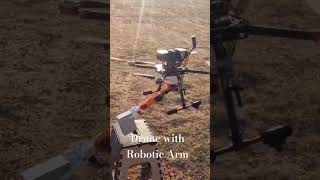
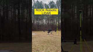
Drones for Aerial Surveying
Enroll to start learning
You’ve not yet enrolled in this course. Please enroll for free to listen to audio lessons, classroom podcasts and take practice test.
Interactive Audio Lesson
Listen to a student-teacher conversation explaining the topic in a relatable way.
Introduction to Drones and their Functionality
🔒 Unlock Audio Lesson
Sign up and enroll to listen to this audio lesson

Welcome, class! Today we're going to discuss drones, specifically how they're used in aerial surveying. Can someone tell me what a drone is?

Isn't it just a flying robot without a pilot?
Exactly! Drones, or Unmanned Aerial Vehicles, can fly autonomously or be remotely controlled. Now can anyone guess what makes drones important for surveying?

Do they take pictures from above?
Yes, they capture high-resolution images, which are crucial for creating topographic maps. Let's remember: Drones = Detailed Data. Can we all agree on this acronym? DDD.

So, they help us see areas that are hard to access?
Absolutely! Great points, everyone. Drones assist in terrain analysis and volume estimation, providing crucial data during the planning phase.
Applications of Drone Technology
🔒 Unlock Audio Lesson
Sign up and enroll to listen to this audio lesson

Let’s dive deeper into how we use drones. What are some ways drones help in surveying?

They can help with volume estimation for large areas, right?
That's correct! The data collected can help estimate material volumes. It’s useful for projects like earthworks. What else?
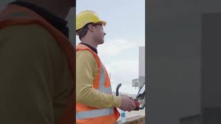
They can also monitor the site while construction is ongoing!
Exactly! Continuous monitoring provides insights into project progress. Remember: Monitor with Drones = Efficiency. Let's use the mnemonic 'MD = E'.
So, they can give us real-time data?
Yes! Real-time data allows for immediate decision-making. Drones streamline workflows. This is key in today's fast-paced construction environment.
Advantages of Drones over Traditional Methods
🔒 Unlock Audio Lesson
Sign up and enroll to listen to this audio lesson
Now let’s discuss advantages. How do drones compare to traditional surveying methods?
Are drones faster than traditional methods?
Yes! Drones can cover large areas in less time. This leads to cost savings. Can anyone think of other benefits?
I think they provide more accurate data too.
Right again! The 3D point clouds give precise detailed information that traditional techniques might miss. Remember the mnemonic 'Fast, Accurate, Cost-Effective = FACE'.
Drones can also be used in areas that are dangerous or hard to reach?
Exactly! Drones enhance safety by reducing the need for human presence in hazardous areas. Excellent contributions today!
The Future of Drones in Civil Engineering
🔒 Unlock Audio Lesson
Sign up and enroll to listen to this audio lesson
Finally, let’s speculate about the future of drones in surveying. What advancements do you foresee?
Maybe they will use AI for better decision-making?
Yes! AI can analyze data instantly, improving efficiency. What else might drones do in the future?
They could conduct thermal surveys for temperature checks!
Exactly! Thermal imaging is a great addition. Let’s remember this with 'Drones = Future Technologies = DFT'.
So, could we see drones inspecting buildings in the future?
Definitely! The possibilities are vast. Drones are at the forefront of innovation in civil engineering.
Introduction & Overview
Read summaries of the section's main ideas at different levels of detail.
Quick Overview
Standard
This section discusses how drones, or UAVs, are utilized in aerial surveying, highlighting their ability to produce topographic maps and point cloud data. This technology is increasingly vital for terrain analysis, volume estimation, and site monitoring within the civil engineering field.
Detailed
Drones for Aerial Surveying
Drones, also known as Unmanned Aerial Vehicles (UAVs), have revolutionized the field of aerial surveying in civil engineering. Their ability to capture high-resolution images and detailed point cloud data makes them integral for various applications, such as terrain analysis and volume estimation.
Key Points:
- High-Resolution Imaging: Drones can capture images that provide detailed insights into the surveyed terrain.
- Topographic Maps: Using the data collected from drone flights, engineers and surveyors can develop accurate topographic maps that assist in planning and design.
- Point Cloud Data: Drones generate 3D point clouds that represent the surface of the scanned area accurately, facilitating precise measurements and analyses.
- Applications: These capabilities are essential for site monitoring, construction progress tracking, and effective decision-making during the planning phases of civil engineering projects.
In essence, drones are a game-changer in surveying, enabling quicker, more accurate, and comprehensive data collection than traditional methods.
Youtube Videos


Audio Book
Dive deep into the subject with an immersive audiobook experience.
Introduction to Drones in Surveying
Chapter 1 of 2
🔒 Unlock Audio Chapter
Sign up and enroll to access the full audio experience
Chapter Content
Unmanned Aerial Vehicles (UAVs) or drones capture high-resolution images, topographic maps, and point cloud data.
Detailed Explanation
Drones, also known as Unmanned Aerial Vehicles (UAVs), are equipped with cameras and sensors that allow them to capture detailed images of the ground below. These images can be processed to create topographic maps, which represent the Earth's surface and its features. Additionally, drones can generate point cloud data, which is a set of data points in space that represent the scanned surface, providing a three-dimensional view. This technology is essential for civil engineering as it provides accurate information for various projects.
Examples & Analogies
Think of drones as high-tech flying cameras that can take pictures from above. Imagine trying to get a clear view of a large park. Instead of walking around every corner, using a drone allows you to see everything at once from the sky, making it faster and easier to understand the layout.
Applications of Drone Data
Chapter 2 of 2
🔒 Unlock Audio Chapter
Sign up and enroll to access the full audio experience
Chapter Content
These are essential for terrain analysis, volume estimation, and site monitoring.
Detailed Explanation
The data collected by drones serves multiple purposes in civil engineering. For terrain analysis, the information helps engineers understand the land's shape and gradient, which is critical when planning roads or buildings. Volume estimation is important for assessing materials, such as the amount of soil needed for construction, as it allows for accurate calculations. Site monitoring involves using drones to regularly check the status of construction sites, ensuring that work is progressing as scheduled and that there are no issues that need immediate attention.
Examples & Analogies
Imagine planning to build a sandcastle on the beach. First, you would want to know how much sand there is in a specific area and how the coastline looks. Using a drone is like having a bird's-eye view, helping you see not just the sand but also the surrounding water, so you know the best spot to build without it being washed away.
Key Concepts
-
Drones: Unmanned aerial vehicles used for capturing images and data.
-
Aerial Surveying: Gathering data from the air for analysis and planning.
-
Point Cloud Data: 3D representations for detailed terrain analysis.
-
Topographic Maps: Maps used in planning and development showcasing features of the land.
Examples & Applications
The use of drones for surveying large construction sites where traditional methods would be time-consuming and risky.
Drones providing data for creating a detailed topographic map of a mountainous area.
Memory Aids
Interactive tools to help you remember key concepts
Rhymes
Drones in the sky, they help us know, What the land is like, below!
Stories
Imagine a builder with a magic bird that flies. This bird shows him the land and how to make it wise.
Memory Tools
D = Data, R = Real-time, O = Overview, N = New heights, E = Efficient.
Acronyms
DRONE = Data from Real-time Overhead, New and Efficient!
Flash Cards
Glossary
- Drones
Unmanned Aerial Vehicles (UAVs) utilized for various applications in surveying and mapping.
- Aerial Surveying
The process of capturing high-resolution images and data from the air for land analysis.
- Point Cloud Data
A collection of data points in 3D space representing the external surface of an object or terrain.
- Topographic Maps
Maps that represent the Earth's surface in three dimensions, including elevation changes.
Reference links
Supplementary resources to enhance your learning experience.