
Applications in Earthquake Engineering
Enroll to start learning
You’ve not yet enrolled in this course. Please enroll for free to listen to audio lessons, classroom podcasts and take practice test.
Interactive Audio Lesson
Listen to a student-teacher conversation explaining the topic in a relatable way.
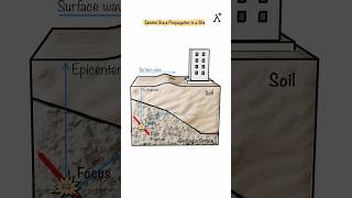
Understanding Site Response Analysis
🔒 Unlock Audio Lesson
Sign up and enroll to listen to this audio lesson

Today we're going to discuss site response analysis. S-waves and Rayleigh waves play significant roles in understanding how soil amplifies seismic waves during an earthquake.

Teacher, what exactly do we mean by soil amplification?
Good question! Soil amplification refers to the increase in amplitude of seismic waves as they travel through the ground. S-waves tend to produce significant lateral forces, and Rayleigh waves, being surface waves, impact the surface structures differently.

Are there specific types of soil that amplify waves more than others?
Absolutely! Soft soils often amplify seismic waves more than hard soils because of their lower shear modulus. Remember, soft soils shake more intensely!

How does this information help engineers?
Great follow-up! Knowing how waves behave helps engineers design structures that can withstand these ground movements, which is essential for earthquake-resistant design.

So, if the soil amplifies the waves, it means that buildings need to be designed differently in different areas?
Exactly! And this brings us nicely to how seismic hazard mapping relies on understanding these wave interactions.
In summary, site response analysis helps engineers anticipate the effects of earthquakes on structures by considering how S-waves and Rayleigh waves interact with different soil types.
Seismic Hazard Mapping
🔒 Unlock Audio Lesson
Sign up and enroll to listen to this audio lesson

Next, let's talk about seismic hazard mapping. This process involves modeling how waves propagate through different regions, isn't that fascinating?
What do we need to consider when creating these maps?
We need to consider the types of seismic waves, their velocities, and local geological conditions. This helps us predict the severity of shaking residents might experience during an earthquake.
Why is it important for hazard mapping to model S-waves and Rayleigh waves specifically?
Both types of waves affect structures differently. S-waves cause significant lateral movement, while Rayleigh waves can shake structures vertically and horizontally, which can lead to different kinds of damage.
So these models can help communities prepare better?
Yes! Effective hazard mapping enables better risk assessment and planning, ensuring that areas at high risk are identified, and suitable measures are taken for safety.
To summarize, seismic hazard mapping is crucial for understanding and preparing for earthquake impacts in various regions based on wave behavior.
Soil-Structure Interaction
🔒 Unlock Audio Lesson
Sign up and enroll to listen to this audio lesson
Now, let’s explore soil-structure interaction, which is key to understanding how buildings will react during earthquakes.
What exactly does soil-structure interaction mean?
It refers to the interaction between the soil beneath a structure and the structure itself, particularly during seismic loading. The behavior of the soil will profoundly affect how buildings respond.
If we know how S-waves and Rayleigh waves behave, how does that help us model these interactions?
Knowing the characteristics of these waves allows us to predict how forces will be transmitted to the foundation, which influences design decisions for safety.
Are there design codes based on this interaction?
Yes, seismic design codes incorporate factors for wave characteristics to ensure that buildings can handle expected seismic forces adequately.
In conclusion, accurate modeling of soil-structure interaction enhances our ability to design earthquake-resistant structures effectively.
Seismic Design Codes
🔒 Unlock Audio Lesson
Sign up and enroll to listen to this audio lesson
Lastly, let’s discuss seismic design codes, which are vital for constructing earthquake-resistant buildings.
How are these codes related to S-waves and Rayleigh waves?
These codes are formulated based on how seismic waves behave, allowing engineers to implement specific measures like using spectral acceleration curves to anticipate forces acting on a building.
So, different regions may have different codes?
Exactly! Areas that experience different levels of seismic activity will have codes tailored to address those unique challenges.
This must help in reducing damage during earthquakes!
Absolutely! Effective seismic design codes play a crucial role in minimizing the impact of earthquakes on structures and ensuring public safety.
In summary, seismic design codes derived from S-wave and Rayleigh wave properties enhance our construction practices, fostering resilience against seismic forces.
Introduction & Overview
Read summaries of the section's main ideas at different levels of detail.
Quick Overview
Standard
This section discusses the applications of Shear waves (S-waves) and Rayleigh waves in earthquake engineering. Key applications include site response analysis for evaluating soil amplification, seismic hazard mapping for understanding ground motion, seismograph interpretation for epicenter location, and improving soil-structure interaction modeling for foundation behavior. These insights inform seismic design codes and enhance earthquake-resistant structures.
Detailed
Applications in Earthquake Engineering
In earthquake engineering, understanding the behavior and characteristics of S-waves and Rayleigh waves is vital for various practical applications.
- Site Response Analysis: Engineers utilize S-waves and Rayleigh waves to evaluate how soil amplifies seismic waves during earthquakes, allowing for a detailed assessment of local site effects.
- Seismic Hazard Mapping: Insights into how these waves propagate is crucial for modeling ground motion in different geographical regions, informing risk assessments and emergency preparedness efforts.
- Seismograph Interpretation: The time delay between the arrival of P-waves, S-waves, and Rayleigh waves assists in locating earthquake epicenters and estimating their magnitudes, which is essential for real-time response and safety measures.
- Soil-Structure Interaction (SSI): By accurately modeling these waves, engineers can predict how foundations will behave under seismic loading, leading to better-designed structures that account for dynamic soil conditions.
- Seismic Design Codes: Building regulations reflect the characteristics of seismic waves, incorporating spectral acceleration curves and design response spectra to enhance earthquake resilience in structures.
Through these applications, the knowledge of S-waves and Rayleigh waves directly influences the safety and reliability of structures in earthquake-prone areas.
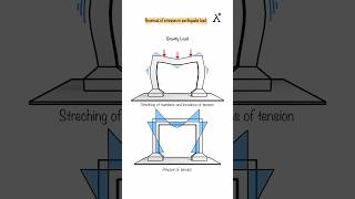
Youtube Videos


Audio Book
Dive deep into the subject with an immersive audiobook experience.
Site Response Analysis
Chapter 1 of 5
🔒 Unlock Audio Chapter
Sign up and enroll to access the full audio experience
Chapter Content
• Site Response Analysis: S-waves and Rayleigh waves are essential inputs for evaluating soil amplification and local site effects.
Detailed Explanation
Site response analysis involves understanding how seismic waves, particularly S-waves and Rayleigh waves, affect the ground and structures at a specific location. When an earthquake occurs, these waves can cause the soil to amplify the shaking effect, which means that buildings might experience stronger ground motions than the ones recorded at seismic stations positioned further away. Engineers perform site response analysis to evaluate these local effects by analyzing the soil's properties and the anticipated seismic waves' characteristics.
Examples & Analogies
Imagine a loudspeaker at a concert. The sound waves from the speaker may appear less intense when you're far away, but if you stand on a soft carpet in front of it, the sound waves bounce around, making the sound much louder right next to you. Similarly, soil types at different locations will either amplify or reduce the shaking from seismic waves.
Seismic Hazard Mapping
Chapter 2 of 5
🔒 Unlock Audio Chapter
Sign up and enroll to access the full audio experience
Chapter Content
• Seismic Hazard Mapping: Understanding the propagation of these waves helps model ground motion for different regions.
Detailed Explanation
Seismic hazard mapping is a crucial process in earthquake engineering that helps identify areas at risk of significant shaking during an earthquake. By analyzing how S-waves and Rayleigh waves propagate through various geological conditions, engineers can develop detailed maps that predict the intensity of ground shaking expected in different regions. These maps help inform building codes, urban planning, and emergency preparedness initiatives.
Examples & Analogies
Think of seismic hazard mapping like weather forecasting. Just as meteorologists predict storms and their intensity in various locations, engineers use mathematical models to predict how earthquake waves will travel through the ground. This helps everyone prepare for 'shaking events'—just like people prepare for rain.
Seismograph Interpretation
Chapter 3 of 5
🔒 Unlock Audio Chapter
Sign up and enroll to access the full audio experience
Chapter Content
• Seismograph Interpretation: Time delay between P, S, and Rayleigh arrivals is used to locate epicenters and estimate magnitudes.
Detailed Explanation
Seismographs are instruments that record the motion of the ground during an earthquake. When an earthquake occurs, the different types of seismic waves (P-waves, S-waves, and Rayleigh waves) arrive at the seismograph at different times. By measuring the time delay between these arrivals, seismologists can use this information to determine the distance to the earthquake's epicenter—where it started—and estimate its magnitude. This process is essential for understanding earthquakes and warning communities about potential risks.
Examples & Analogies
It's similar to a starting signal in a race; when the starter gun goes off (the earthquake), the runners (waves) move at different speeds. By timing how long it takes each runner to cross the finish line (the seismograph), officials can figure out where the race started and its overall intensity.
Soil-Structure Interaction (SSI)
Chapter 4 of 5
🔒 Unlock Audio Chapter
Sign up and enroll to access the full audio experience
Chapter Content
• Soil-Structure Interaction (SSI): Accurate modeling of these waves improves prediction of foundation behavior during seismic loading.
Detailed Explanation
Soil-structure interaction (SSI) refers to how the soil beneath a structure behaves when subjected to seismic forces. The characteristics of S-waves and Rayleigh waves influence how foundations respond during an earthquake. By accurately modeling these wave interactions with structures, engineers can better predict potential issues, such as excessive settlement, tilting, or damage to the foundations. This information guides the design of buildings to withstand seismic forces more effectively.
Examples & Analogies
Consider a table sitting on a cloth. If someone shakes the table (representing seismic waves), the way the cloth moves (soil response) affects how stable the table is. By understanding that interaction, we can design the table and the cloth to work together better during the shaking.
Seismic Design Codes
Chapter 5 of 5
🔒 Unlock Audio Chapter
Sign up and enroll to access the full audio experience
Chapter Content
• Seismic Design Codes: Wave characteristics are reflected in building codes via spectral acceleration curves and design response spectra.
Detailed Explanation
Seismic design codes provide guidelines for constructing buildings that can resist the forces generated by earthquakes. These codes incorporate information about wave characteristics, such as how fast they travel and how strong they are, through tools like spectral acceleration curves and design response spectra. By adhering to these codes, engineers can ensure that structures are built to withstand the expected level of seismic activity in their locations, ultimately protecting lives and reducing damage.
Examples & Analogies
Think of seismic design codes like building regulations for safe houses in areas prone to hurricanes. Just as builders use specific guidelines and standards to ensure homes can withstand strong winds and flooding, engineers use seismic codes to ensure buildings can handle earthquakes.
Key Concepts
-
Site Response Analysis: Evaluating how soil amplifies seismic waves during earthquakes.
-
Seismic Hazard Mapping: Modeling wave propagation to assess risk in various regions.
-
Soil-Structure Interaction (SSI): The dynamic interaction between buildings and the soil during seismic events.
-
Seismic Design Codes: Regulations that ensure buildings can withstand seismic forces.
Examples & Applications
Site response analysis demonstrated that buildings on soft soil are more vulnerable to ground shaking, necessitating design alterations to enhance safety.
Seismic hazard mapping in regions like California helps identify areas at risk, allowing for better preparedness and response strategies.
Memory Aids
Interactive tools to help you remember key concepts
Rhymes
S-waves shear, Rayleigh waves do sway, Together they help keep strong buildings at bay.
Stories
Imagine a strong earthquake shaking a city. S-waves move through the soil, creating horizontal forces, while Rayleigh waves roll along the surface like ocean waves, both working together to test the structures standing tall above.
Memory Tools
Remember S-S-R for the three main applications: Site response, Seismic hazard, and Soil-structure interaction!
Acronyms
Use the acronym S.H.I.P. for Seismic Hazard, Interaction, and Protection, emphasizing key functions of these seismic applications.
Flash Cards
Glossary
- Swaves
Secondary or shear waves that cause particle motion perpendicular to the direction of wave propagation.
- Rayleigh Waves
Surface seismic waves that travel along the Earth's surface and exhibit retrograde elliptical motion.
- Site Response Analysis
The evaluation of how seismic waves amplify during passage through different soil types.
- Seismic Hazard Mapping
The process of modeling how seismic waves propagate in different geographical areas to assess earthquake risk.
- SoilStructure Interaction (SSI)
The study of how the soil and the structure interact dynamically during seismic activity.
- Seismic Design Codes
Building regulations that incorporate knowledge about seismic waves to enhance earthquake-resistant design.
Reference links
Supplementary resources to enhance your learning experience.