
Instrumentation for Monitoring S and Rayleigh Waves
Enroll to start learning
You’ve not yet enrolled in this course. Please enroll for free to listen to audio lessons, classroom podcasts and take practice test.
Interactive Audio Lesson
Listen to a student-teacher conversation explaining the topic in a relatable way.
Understanding Strong Motion Seismometers
🔒 Unlock Audio Lesson
Sign up and enroll to listen to this audio lesson

Today we'll discuss strong motion seismometers. These instruments record acceleration data during an earthquake. Can anyone tell me what types of ground motion they measure?

They record both horizontal and vertical movements.
Correct! They're vital for distinguishing between P-waves, S-waves, and surface waves. Remember the acronym 'DASH' for their roles: Detect, Analyze, Save data, and Help structure safety. What do you think happens if we don't use such technology?

We wouldn't have accurate data to improve building designs and prepare for future earthquakes.

Exactly! This data helps us understand seismic impacts better.
To summarize, strong motion seismometers are crucial for collecting seismic wave data, which can guide improvements in earthquake resilience.
Exploring Surface Wave Arrays
🔒 Unlock Audio Lesson
Sign up and enroll to listen to this audio lesson

Let’s talk about surface wave arrays. Who can explain what these are used for?

They use geophones to measure surface wave velocities!
Yes! And this helps in site classification. Can anyone explain why classification is important?
It impacts how we design structures in different terrains.
Exactly! And it's essential for microzonation studies as well. Remember the acronym 'CLASS' – Classify, Locate, Analyze, Specify, and Survey. These steps form the foundation for better engineering predictions. Can anyone think of any specific scenarios where this might be crucial?
In cities built on softer soils or riverbanks!
Great point! To summarize, surface wave arrays are essential tools for assessing seismic risk and enhancing our understanding of local geology.
Interferometry and Ground-Based Radar
🔒 Unlock Audio Lesson
Sign up and enroll to listen to this audio lesson
Finally, let's discuss interferometry and ground-based radar. Can anyone explain how InSAR assists in post-earthquake evaluations?
It detects surface displacements caused by waves.
Correct! This is critical for mapping ground deformation. Who can remind us why mapping is significant?
It helps us study the impact of an earthquake on structures and plan future responses.
Absolutely! You can think of it as a 'MAP' strategy: Monitor, Analyze, Plan. Let's not forget that these advanced tools are improving our effectiveness at mitigating risks. In summary, InSAR and radar technology provide detailed insights into seismic activities, paving the way for improved safety measures.
Introduction & Overview
Read summaries of the section's main ideas at different levels of detail.
Quick Overview
Standard
Instrumentation plays a crucial role in capturing seismic wave data. Techniques such as strong motion seismometers and surface wave arrays provide valuable information crucial for earthquake engineering. Emerging technologies like interferometry and ground-based radar enhance our understanding of ground deformation linked to seismic events.
Detailed
Instrumentation for Monitoring S and Rayleigh Waves
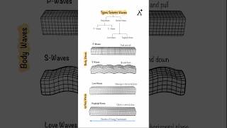
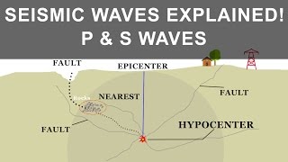
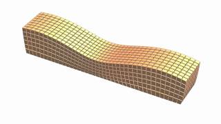
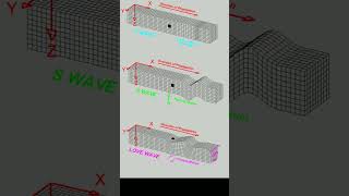
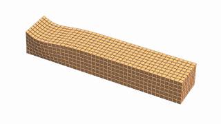
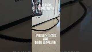
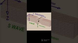
The monitoring of seismic activities involving Shear Waves (S-waves) and Rayleigh Waves is essential in earthquake engineering to analyze ground motion and its effects on structures. In this section, we explore several key instruments and techniques used in this monitoring:
1. Strong Motion Seismometers
- These devices are installed in dense arrays to reliably record both horizontal and vertical acceleration data during seismic events.
- They can differentiate between primary, secondary, and surface waves, helping in the analysis of ground motions.
2. Surface Wave Arrays
- Comprised of geophones or accelerometers, these arrays are strategically placed across a site to collect surface wave velocity profiles.
- They are critical for site classification and conducting microzonation studies, providing insights into how different geological conditions affect seismic wave propagation.
3. Interferometry and Ground-Based Radar
- Advanced tools like InSAR (Interferometric Synthetic Aperture Radar) allow for the detection of surface displacements caused by the passage of Rayleigh waves.
- These techniques are especially useful for post-earthquake mapping of ground deformations, revealing patterns that can inform future engineering practices.
In summary, proper instrumentation is key in accurately monitoring these seismic waves, leading to better earthquake preparedness and building design.
Youtube Videos


Audio Book
Dive deep into the subject with an immersive audiobook experience.
Strong Motion Seismometers
Chapter 1 of 3
🔒 Unlock Audio Chapter
Sign up and enroll to access the full audio experience
Chapter Content
• Installed in dense arrays to record horizontal and vertical acceleration data.
• Capable of distinguishing between P, S, and surface waves.
Detailed Explanation
Strong motion seismometers are instruments designed to measure the ground's acceleration during seismic events. These sensors are often arranged in dense arrays across an area to provide comprehensive data. They can effectively distinguish the types of seismic waves that pass through them, identifying Primary waves (P-waves), Secondary waves (S-waves), and surface waves. This capability is crucial for understanding how different seismic waves impact structures.
Examples & Analogies
Imagine having a series of microphones positioned throughout a concert hall. Each microphone picks up not just the music (the overall sound) but can also differentiate between various instruments (the different types of seismic waves). This allows engineers to get a clearer picture of how seismic waves affect buildings and infrastructure during an earthquake.
Surface Wave Arrays
Chapter 2 of 3
🔒 Unlock Audio Chapter
Sign up and enroll to access the full audio experience
Chapter Content
• Arrays of geophones or accelerometers placed across a site to capture surface wave velocity profiles.
• Used for site classification and microzonation studies.
Detailed Explanation
Surface wave arrays consist of multiple geophones or accelerometers strategically placed over a geological site. These devices measure how surface waves travel through the ground, helping to create detailed velocity profiles of these waves. The information gathered is essential for classifying different types of land (site classification) and studying how those areas might respond to seismic activity (microzonation studies). This helps in predicting potential hazards and planning for earthquake-resistant structures.
Examples & Analogies
Think of surface wave arrays as a series of race timers along a marathon route. Just as the timers help track runners' speeds to identify which parts of the course are faster or slower, surface wave arrays track seismic waves to understand how quickly and effectively they travel through different ground types.
Interferometry and Ground-Based Radar
Chapter 3 of 3
🔒 Unlock Audio Chapter
Sign up and enroll to access the full audio experience
Chapter Content
• Modern tools like InSAR (Interferometric Synthetic Aperture Radar) can detect surface displacements due to Rayleigh wave passage.
• Useful for post-earthquake ground deformation mapping.
Detailed Explanation
Interferometry, particularly using InSAR technology, involves analyzing radar images to detect even minuscule changes in the Earth's surface, which can occur when Rayleigh waves pass through. This technique is employed after earthquakes to map how the ground has shifted or deformed. Understanding these surface displacements is vital for assessing earthquake damage and informing recovery decisions.
Examples & Analogies
Imagine taking a photograph of a landscape every day and then comparing them side by side. You would notice changes in the scenery, such as a tree that fell over after a storm. Similarly, InSAR acts like these photos, capturing subtle shifts in the Earth's surface over time and showing how it responds to seismic activity.
Key Concepts
-
Strong Motion Seismometers: Tools vital for capturing seismic wave data.
-
Surface Wave Arrays: Arrays that analyze surface wave velocities for better site classifications.
-
Interferometry: Innovative technology for detecting surface displacements due to seismic activity.
Examples & Applications
Strong motion seismometers are used in earthquake-prone cities to record seismic activity and inform building codes.
Surface wave arrays are deployed during seismic risk assessments to improve engineering practices.
InSAR has been crucial in post-earthquake analysis, such as mapping damage in affected urban areas.
Memory Aids
Interactive tools to help you remember key concepts
Rhymes
When waves come near, we want no fear, with seismometers clear, our safety is dear!
Stories
Imagine a city built on soft soil, where engineers use surface arrays as tools to help the ground foil!
Memory Tools
For S-waves and surface data, think 'GEM' - Geophones, Earthquakes, Motion!
Acronyms
Remember 'SAX' for our instruments
Seismometers
Accelerometers
eXperts in readings.
Flash Cards
Glossary
- Strong Motion Seismometers
Instruments that record horizontal and vertical acceleration data during seismic events.
- Surface Wave Arrays
Geophone or accelerometer arrays used to capture surface wave velocity profiles for seismic analysis.
- Interferometry
A technique using radar to detect and measure changes in the Earth's surface after seismic waves pass.
Reference links
Supplementary resources to enhance your learning experience.